Area Overview for BD7 1LP
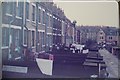
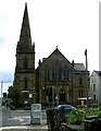
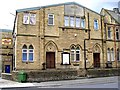
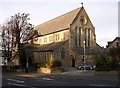
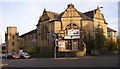
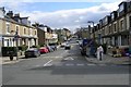
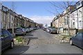
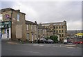
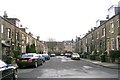
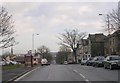
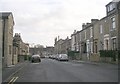
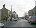
Photos of BD7 1LP
Area Information
Living in BD7 1LP places you at the heart of Bradford’s urban core, within a tightly defined postcode area spanning 1.1 hectares. This small residential cluster sits within the City Ward, a historically significant part of Bradford’s city centre, bounded by the inner ring road. With a population of 1,741 and a density of 1,665 people per square kilometre, the area is compact yet vibrant, offering proximity to key amenities and transport links. Daily life here is shaped by its central location, with easy access to retail, education, and rail networks. The area’s character is defined by its mix of residential properties and urban infrastructure, though its small size means it is more of a micro-locale than a standalone district. For those seeking a central location without sprawling suburbs, BD7 1LP provides a concentrated hub of activity, though its density may feel intense for some. The area’s proximity to Bradford’s landmarks and services makes it a practical choice for commuters and those prioritising connectivity over expansive living spaces.
- Area Type
- Postcode
- Area Size
- 1.1 hectares
- Population
- 1741
- Population Density
- 1665 people/km²
The property market in BD7 1LP is characterised by low home ownership, with only 28% of residents owning their homes. This points to a market that is largely rental-based, with houses being the predominant accommodation type. Given the area’s small size—just 1.1 hectares—and high population density, the housing stock is likely limited to smaller properties or multi-family units. For buyers, this suggests a challenging market where competition for available properties may be fierce, particularly given the area’s proximity to central amenities. The compact nature of BD7 1LP means that any property here is likely to be part of a tightly knit residential cluster, with limited scope for expansion or redevelopment. Prospective buyers should consider the area’s density and rental-oriented nature when evaluating long-term value, as the market may be more responsive to demand from tenants than to owner-occupiers seeking investment.
House Prices in BD7 1LP
Showing 50 properties
| Address | Type | Beds | Baths | Last Sale Price | Last Sale Date | |
|---|---|---|---|---|---|---|
| 49 Fieldhead Street, Bradford, BD7 1LP | house | 3 | - | £50,000 | Jun 2023 | |
| 50 Fieldhead Street, Bradford, BD7 1LP | house | - | - | £63,500 | Aug 2022 | |
| 57 Fieldhead Street, Bradford, BD7 1LP | house | - | - | £67,000 | Oct 2021 | |
| 74 Fieldhead Street, Bradford, BD7 1LP | Terraced | 2 | 1 | £64,500 | Apr 2021 | |
| 66 Fieldhead Street, Bradford, BD7 1LP | house | - | - | £67,000 | May 2019 | |
| 61 Fieldhead Street, Bradford, BD7 1LP | house | - | - | £63,000 | Jan 2019 | |
| 52 Fieldhead Street, Bradford, BD7 1LP | house | - | - | £67,000 | Dec 2018 | |
| 47 Fieldhead Street, Bradford, BD7 1LP | house | - | - | £60,000 | Dec 2017 | |
| 72 Fieldhead Street, Bradford, BD7 1LP | house | - | - | £51,000 | Jan 2016 | |
| 45 Fieldhead Street, Bradford, BD7 1LP | Terraced | - | - | £46,500 | Jun 2015 |
Energy Efficiency in BD7 1LP
The lifestyle in BD7 1LP is defined by its proximity to essential amenities, including five retail outlets such as Asda Bradford, Morrisons Scholemoor, and Iceland Manningham. These shops provide everyday convenience, from groceries to household items, reducing the need for long journeys. The area’s rail links, with stations like Bradford Forster Square, offer easy access to broader networks, facilitating both commuting and leisure travel. While the data does not specify parks or leisure facilities, the compact nature of the area suggests that nearby public spaces may be limited, requiring residents to venture slightly further for recreation. The mix of retail and transport options contributes to a practical, urban lifestyle, where daily needs are met within walking or short transit distance. However, the lack of detailed information on leisure amenities means that residents may need to look beyond the immediate postcode for a more diverse range of activities.
Amenities
Schools
Residents of BD7 1LP have access to a range of educational institutions, including three primary schools—Princeville Primary School, St William’s Catholic Primary School, and Willowfield School—alongside two academies: Eden Boys’ Leadership Academy, Bradford (rated outstanding by Ofsted) and Co-op Academy Princeville (rated good). The presence of both primary and academy schools offers families a choice between traditional and specialist education. Eden Boys’ Leadership Academy’s outstanding rating highlights its strong academic and vocational provision, while the Co-op Academy provides a solid foundation for younger students. The diversity of school types ensures that parents can select institutions that align with their priorities, whether they seek faith-based education or academically focused environments. For families, this mix of options is a significant advantage, though the proximity of schools to residential areas may influence property desirability and local community cohesion.
| Rank | School | Type | Entry gender | Ages |
|---|
Explore more schools in this area
Go to Schools tabDemographics
The community in BD7 1LP is predominantly composed of adults aged 30–64, despite a median age of 22. This suggests a mix of younger residents and a more established population, possibly including students or workers in nearby sectors. Home ownership is low at 28%, indicating that the majority of residents are likely to be renters, which may reflect the area’s role as a secondary housing market within Bradford. The accommodation type is primarily houses, though the high population density suggests these are often smaller or multi-occupancy units. The predominant ethnic group is Asian, as recorded in the data, which influences the cultural fabric of the area. With a population density of 1,665 per square kilometre, the area is highly populated, which may impact local services and community dynamics. This density, combined with the demographic profile, suggests a community that is both active and interconnected, though potentially resource-constrained in terms of public amenities.
Household Size
Accommodation Type
Tenure
Ethnic Group
Religion
Household Composition
Age
Household Deprivation
NS-SEC
Explore more demographic insights in this area
Go to Demographics tabPlanning
Planning Constraints
- Flood RiskPremium
- Ramsar Wetland SitesPremium
- Area of Outstanding Natural BeautyPremium
- Protected Nature ReservePremium
- Protected WoodlandPremium