Area Overview for BD5 9RL
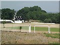
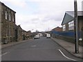
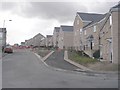
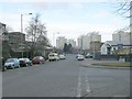
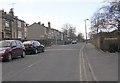
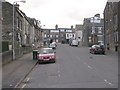
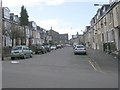
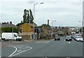
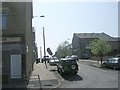
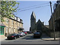
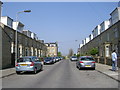
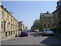
Photos of BD5 9RL
Area Information
Living in BD5 9RL means inhabiting a small, tightly knit residential cluster within Little Horton, a ward in Bradford, West Yorkshire. With a population of 2,075, the area is compact yet historically rich, shaped by centuries of transition from rural farmland to industrial housing. Its coordinates—53.78°N, 1.78°W—place it southeast of Bradford’s city centre, where the landscape slopes gently. The community reflects a blend of historical legacy and modern practicality, with amenities like rail stations and retail outlets within practical reach. BD5 9RL’s character is defined by its proximity to landmarks such as All Saints’ Church, built in 1864, and the Margaret McMillan Teacher Training College, a tribute to the area’s educational heritage. While the ward was once noted as the second most deprived in the UK, today’s residents benefit from strong rail links, independent schools, and a diverse population. Daily life here balances the convenience of urban connectivity with the quietude of a smaller, more manageable community.
- Area Type
- Postcode
- Area Size
- Not available
- Population
- 2075
- Population Density
- 10985 people/km²
BD5 9RL’s property market is characterised by a low home ownership rate of 34%, pointing to a rental-dominated landscape. Houses are the primary accommodation type, though the small population of 2,075 implies limited housing stock within the postcode itself. This suggests that buyers may need to look beyond BD5 9RL’s immediate boundaries to find available properties, potentially increasing competition in nearby areas. The area’s compact size means housing options are constrained, with little scope for new developments given its historical and infrastructural context. For those seeking owner-occupied homes, the market may be challenging, requiring flexibility in location or property type. The predominance of houses over flats or apartments also means that rental properties are likely to be larger, catering to families or individuals prioritising space over density.
House Prices in BD5 9RL
No properties found in this postcode.
Energy Efficiency in BD5 9RL
Life in BD5 9RL is supported by a range of nearby amenities, including five retail outlets such as Asda Little, Lidl Bankfoot, and Spar Manchester, ensuring everyday shopping needs are met. The rail network, with stations like Bradford Interchange, offers direct links to employment hubs and cultural centres in Bradford. While the area lacks large parks or leisure facilities, its historical sites—such as the converted poorhouse and remnants of All Saints’ Church—add a layer of local interest. The presence of retail and transport options within walking distance contributes to a convenient, though modest, lifestyle. The area’s compact size means residents must venture slightly further for larger leisure or recreational opportunities, but the immediate surroundings provide sufficient practicality for daily living.
Amenities
Schools
The nearest school to BD5 9RL is Eternal Light, an independent institution with an outstanding Ofsted rating. This school offers a high standard of education, though the absence of state schools in the data suggests that families in the area may rely heavily on private education. The presence of an outstanding-rated independent school could be a significant draw for households prioritising academic excellence, though it may also limit options for those seeking state-funded alternatives. Given the area’s demographic diversity, the availability of a single high-quality school may influence housing decisions, as families often prioritise proximity to educational institutions. Parents should consider whether the school’s focus aligns with their child’s needs, particularly if additional schooling options are not readily accessible.
| Rank | School | Type | Entry gender | Ages |
|---|
Explore more schools in this area
Go to Schools tabDemographics
The demographic profile of BD5 9RL reveals a median age of 22, though the most common age range is adults aged 30–64, suggesting a mix of younger and middle-aged residents. Home ownership stands at 34%, indicating a rental-heavy market, with houses being the predominant accommodation type. The area’s predominant ethnic group is Asian_total, reflecting broader migration patterns that began in the mid-20th century, when Gujarati Indian, Pakistani, East African, and African Caribbean migrants settled here to fill post-war labour shortages. This diversity has shaped a community with shared cultural practices and heritage. The low home ownership rate and high proportion of adult residents suggest a transient or rental-driven population, possibly influenced by economic factors or employment opportunities in nearby industrial zones. The area’s history as a middle-class enclave in the 19th century contrasts with its later designation as a deprived ward, though current data does not quantify modern deprivation levels.
Household Size
Accommodation Type
Tenure
Ethnic Group
Religion
Household Composition
Age
Household Deprivation
NS-SEC
Explore more demographic insights in this area
Go to Demographics tabPlanning
Planning Constraints
- Flood RiskPremium
- Ramsar Wetland SitesPremium
- Area of Outstanding Natural BeautyPremium
- Protected Nature ReservePremium
- Protected WoodlandPremium