Area Overview for BD22 9HG
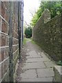
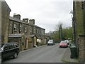
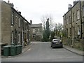
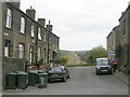
Photos of BD22 9HG
Area Information
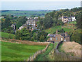
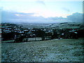
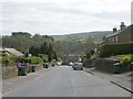
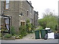
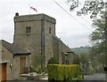
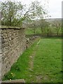
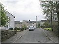
Oxenhope sits within the BD22 9HG postcode, covering a small residential cluster of just 0.037 square kilometres in West Yorkshire. This compact area houses a population of 1,569 people, resulting in a density of 1,176 people per square kilometre. The name derives from Old English, reflecting its origins as a recessed valley used for grazing cattle brought from Bradford during Saxon times. You will find the village encompasses what were originally separate settlements, including Uppertown, Lowertown, Leeming, Horkinstone, and the historic hamlets of Marsh and Shaw. The modern layout retains the character of a working Victorian industrial village defined by its dense history of woollen mills. Today, the geography is marked by a damp valley surrounded by moorland. The settlements were established on high, well-drained land from the 1500s to avoid the heavy clay soils of the valley floor. You can see historic stone-built houses dating back to the 1600s on these hillsides. Living in BD22 9HG means inhabiting a rural, valley-based community that has transformed from a site of industrial activity into a quiet residential location. The Keighley & Worth Valley Railway reached the area in 1867, connecting it historically to the wider trade networks of the Pennines.
- Area Type
- Postcode
- Area Size
- 3672 m²
- Population
- 1569
- Population Density
- 1176 people/km²
The housing market in BD22 9HG is characterised by a low rental figure, with 78% of homes being owner-occupied. This high percentage of owner-occupiers indicates a stable, established market rather than a speculative or high-turnover rental sector. The predominant accommodation type is houses, which aligns with the village's historic layout and the need for space given the industrial past. You are looking at a stock that primarily consists of family homes suitable for settled living. This area operates as a traditional residential neighbourhood where residents buy to stay rather than to trade frequently. The low level of private renting reinforces the community feel you would expect in a civil parish of this scale. When assessing properties here, you will find that the market is driven by owners who value the connection to the village's character. The prominence of houses over flats or detached blocks is typical for this part of West Yorkshire. Buyers entering the market here should expect competition from local owners looking to move up or down the property ladder. The high ownership rate means that sale prices are often influenced by the specific quality of the individual property and its plot rather than speculative investment trends. The area represents a classic model of the British village market.
House Prices in BD22 9HG
Showing 15 properties
| Address | Type | Beds | Baths | Last Sale Price | Last Sale Date | |
|---|---|---|---|---|---|---|
| 6, Charles Court, Station Road, Oxenhope, Keighley, BD22 9HG | Flat | 2 | 2 | £140,000 | Jul 2025 | |
| 7, Charles Court, Station Road, Oxenhope, Keighley, BD22 9HG | Flat | 2 | 2 | £170,000 | Jul 2025 | |
| 11, Charles Court, Station Road, Oxenhope, Keighley, BD22 9HG | Flat | - | - | £125,000 | May 2024 | |
| 10, Charles Court, Station Road, Oxenhope, Keighley, BD22 9HG | Flat | - | - | £139,000 | Mar 2021 | |
| 12, Charles Court, Station Road, Oxenhope, Keighley, BD22 9HG | Flat | - | - | £151,000 | Apr 2008 | |
| 9, Charles Court, Station Road, Oxenhope, Keighley, BD22 9HG | Flat | - | - | £192,000 | Feb 2007 | |
| 16, Charles Court, Station Road, Oxenhope, Keighley, BD22 9HG | Terraced | 3 | 1 | £96,500 | Jun 2002 | |
| 5, Charles Court, Station Road, Oxenhope, Keighley, BD22 9HG | Flat | - | - | £76,950 | Apr 2002 | |
| 8, Charles Court, Station Road, Oxenhope, Keighley, BD22 9HG | Flat | - | - | £77,000 | Mar 1997 | |
| 3, Charles Court, Station Road, Oxenhope, Keighley, BD22 9HG | house | 4 | - | - | - |
Energy Efficiency in BD22 9HG
Residents of BD22 9HG have access to essential amenities within practical reach of their homes. The local retail scene includes five notable shops, namely Co-op Oxenhope, Co-op Haworth, and Spar. These venues form the core of daily shopping for food and essentials. There are five transport-related amenities clustered around Oxenhope, Haworth, and Oakworth. These hubs support local travel needs beyond the immediate village. Rail connectivity is the primary method for longer journeys, with access to Keighley Railway Station, Bingley Railway Station, and Hebden Bridge Railway Station within reach. These stations connect the area to major city destinations and serve as the main link out of the Pennines. You do not have data on specific bus services or cafe names, so the focus remains on retail and rail. The concentration of Co-op stores indicates a convenient supply chain for groceries. The village character combined with these accessible transport links creates a functional rural lifestyle. Living in BD22 9HG means balancing village tranquility with access to regional transport nodes.
Amenities
Schools
Primary education is represented by Oxenhope CofE Primary School, which is listed in the nearby schools data. The school operates under primary education type and holds a good Ofsted rating. As the only educational institution with a rating provided in the dataset, it serves the immediate residential cluster. You will not find data on secondary schools within the provided information, so families must look beyond the immediate BD22 9HG boundary for older children. The presence of a community primary school suggests that young children are catered for locally before they transition elsewhere. The good Ofsted rating indicates that the school meets the required standards for education and care. This is a traditional Church of England primary institution, which may appeal to families seeking religious education in a controlled environment. The single name provided reinforces the small scale of the local education sector in this specific postcode area.
| Rank | School | Type | Entry gender | Ages |
|---|
Explore more schools in this area
Go to Schools tabDemographics
The community in BD22 9HG skews towards middle-aged adults, with a median age of 47 years. The most common age group consists of adults between 30 and 64 years. This demographic profile mirrors a settled population rather than a young, transient workforce. Home ownership is high at 78%, indicating that the vast majority of residents own their properties. The predominant accommodation type remains houses, consistent with the village's suburban and historic layout. The area maintains a predominantly White ethnic composition. You will find a stable community where long-term residency is the norm. There are no significant data points provided regarding deprivation or income levels, but the high home ownership percentage suggests financial stability among residents. The lack of private rental stock implies that most families have established roots in the parish. When you look at the people living here, you see a cohort that has likely grown with the changing demographics of the village over decades. The settlement's history of industrial employment has evolved into a quieter residential existence. The high density of 1,176 people per square kilometre is notable for a rural village, suggesting efficient land use in this small civil parish.
Household Size
Accommodation Type
Tenure
Ethnic Group
Religion
Household Composition
Age
Household Deprivation
NS-SEC
Explore more demographic insights in this area
Go to Demographics tabPlanning
Planning Constraints
- Flood RiskPremium
- Ramsar Wetland SitesPremium
- Area of Outstanding Natural BeautyPremium
- Protected Nature ReservePremium
- Protected WoodlandPremium