Area Overview for BD20 8TX
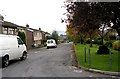
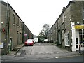
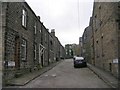
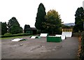
Photos of BD20 8TX


Area Information
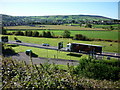
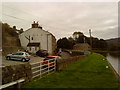
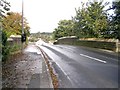
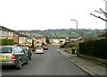
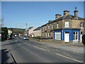
BD20 8TX lies within the civil parish of Glusburn and Cross Hills in North Yorkshire, a small residential cluster with a population of 1,219. Nestled halfway between Skipton and Keighley, the area combines historical roots with modern convenience. The village of Glusburn, mentioned in the Domesday Book as *Glusebrun*, sits alongside the newer settlement of Cross Hills, forming a tight-knit community with nearby villages like Kildwick and Eastburn. The area is administered by North Yorkshire Council and benefits from proximity to key transport routes, including the A6069 and historic canals. Locals enjoy a mix of rural charm and accessible amenities, from the Pinnacles monuments—Lund’s Tower and the “Salt Pot” and “Pepper Pot” structures—overlooking Cowling Moor to the remnants of 19th-century textile mills. With a median age of 47 and a population skewed toward adults aged 30–64, the area reflects a mature, stable community. Daily life here balances historical heritage with practical living, supported by nearby retail, rail, and metro links.
- Area Type
- Postcode
- Area Size
- Not available
- Population
- 1219
- Population Density
- 4396 people/km²
The property market in BD20 8TX is characterised by a 53% home ownership rate, with houses forming the predominant accommodation type. This suggests a residential area where many properties are owner-occupied, though the relatively modest ownership rate indicates a significant rental market. The small population and clustered layout mean the housing stock is limited, with buyers needing to consider nearby towns like Skipton or Keighley for broader options. The presence of historic homes, such as the remnants of 19th-century textile mills, may appeal to those seeking character properties, though modern housing developments are likely scarce. Given the area’s size and proximity to transport links, property values may reflect both rural tranquillity and accessibility to urban amenities. Buyers should also consider the local infrastructure, as the area’s small size may limit expansion or new builds.
House Prices in BD20 8TX
No properties found in this postcode.
Energy Efficiency in BD20 8TX
Daily life in BD20 8TX is shaped by its accessible amenities, including five retail outlets such as Co-op Cross, Morrisons Daily, and Asda Cross, which cater to everyday needs. The area’s rail and metro stations—Cononley, Steeton & Silsden, and Skipton—provide easy access to nearby towns, while the proximity to historic sites like The Pinnacles adds cultural value. The village’s small size fosters a tight-knit community, with local shops and services along Colne Road contributing to a sense of place. Residents can enjoy the Pinnacles’ views over Cowling Moor or explore the remnants of 19th-century mills, blending history with modern convenience. The availability of retail, transport, and recreational spots ensures a balanced lifestyle, making the area suitable for those who appreciate both rural tranquillity and urban accessibility.
Amenities
Schools
The nearest school to BD20 8TX is Glusburn Community Primary School, which serves the local area with a good Ofsted rating. This primary school is a key educational resource for families in the parish, though no secondary schools are listed in the data. The absence of secondary education options within the immediate area may necessitate commuting to nearby towns like Skipton or Keighley for older children. The good rating at Glusburn Community Primary School suggests a focus on quality early education, which is crucial for families prioritising school performance. However, the lack of detailed information on secondary schooling means prospective buyers should investigate further to understand long-term educational needs. The school’s presence reinforces the area’s appeal to families seeking a stable, community-oriented environment for their children.
| Rank | School | Type | Entry gender | Ages |
|---|
Explore more schools in this area
Go to Schools tabDemographics
The population of BD20 8TX is predominantly adults aged 30–64, with a median age of 47. Home ownership stands at 53%, indicating a mix of owner-occupied properties and rental stock. The accommodation type is primarily houses, reflecting a residential character distinct from high-density housing. The predominant ethnic group is White, though specific data on diversity or deprivation is not provided. This age profile suggests a community with established residents, many of whom may be in their prime working years or nearing retirement. The relatively low home ownership rate implies a portion of the population may rent, potentially including younger families or professionals. The absence of detailed diversity statistics means the area’s cultural composition remains less defined, but the demographic stability—rooted in a mature age group—suggests a focus on long-term residency rather than transient populations.
Household Size
Accommodation Type
Tenure
Ethnic Group
Religion
Household Composition
Age
Household Deprivation
NS-SEC
Explore more demographic insights in this area
Go to Demographics tabPlanning
Planning Constraints
- Flood RiskPremium
- Ramsar Wetland SitesPremium
- Area of Outstanding Natural BeautyPremium
- Protected Nature ReservePremium
- Protected WoodlandPremium