Area Overview for BD20 8SX
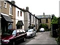
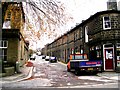
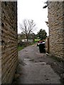
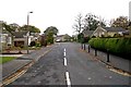
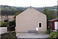
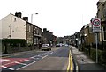
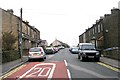
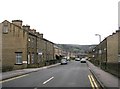
Photos of BD20 8SX
Area Information
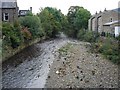
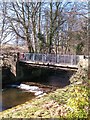
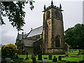
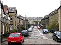
BD20 8SX lies within the small residential cluster of Glusburn and Cross Hills, a civil parish in North Yorkshire. This area, with a population of just over 1,200, sits midway between Skipton and Keighley, blending historical roots with modern convenience. The village of Glusburn, mentioned in the Domesday Book, shares its postcode district with newer settlements like Cross Hills, creating a compact, close-knit community. Residents benefit from proximity to nearby towns, with rail links to Skipton, Steeton, and Cononley offering easy access to regional hubs. The area’s character is shaped by its rural setting, with historic landmarks such as The Pinnacles and Glusburn Old Hall nearby. Daily life here is defined by a mix of traditional and practical amenities, from local shops to community-focused schools. The low crime risk and excellent broadband connectivity (98/100) support both home-based work and leisure, while the predominance of houses suggests a stable, family-oriented demographic. Living in BD20 8SX means balancing rural tranquillity with accessible transport and services, ideal for those seeking a quieter lifestyle without sacrificing connectivity.
- Area Type
- Postcode
- Area Size
- Not available
- Population
- 1219
- Population Density
- 4396 people/km²
The property market in BD20 8SX is characterised by a 53% home ownership rate, with houses forming the majority of the housing stock. This suggests a market skewed towards owner-occupied properties rather than rentals, though the relatively low ownership rate implies a notable presence of rental homes. The predominance of houses, as opposed to flats or apartments, indicates a traditional, possibly older housing stock, which may appeal to buyers seeking larger properties with garden space. Given the area’s small size, the housing market is likely limited to the immediate vicinity, with limited scope for expansion. Buyers should consider the stability of the market, as the low crime risk and absence of planning constraints (such as protected areas) may make it an attractive option for those prioritising safety and simplicity. However, the limited data on property types or price ranges means potential buyers must conduct further local inquiries to assess specific opportunities.
House Prices in BD20 8SX
No properties found in this postcode.
Energy Efficiency in BD20 8SX
Residents of BD20 8SX have access to a range of practical amenities within reach. The area’s retail sector includes five notable stores: Co-op Cross, Morrisons Daily, and Asda Cross, offering everyday shopping needs. Nearby rail stations—Cononley, Steeton & Silsden, and Skipton—provide easy access to regional hubs, while five metro stops (Ingrow West, Oakworth, Damems) enhance local mobility. Though the data does not specify parks or leisure facilities, the historical presence of landmarks like The Pinnacles and Glusburn Old Hall suggests opportunities for outdoor recreation. The combination of local shops, transport links, and proximity to larger towns creates a lifestyle that balances convenience with the potential for rural amenities. This mix supports both daily errands and broader exploration, catering to residents’ practical and social needs.
Amenities
Schools
The nearest school to BD20 8SX is Glusburn Community Primary School, which serves the area with a good Ofsted rating. This primary school is a key local institution, offering education for younger children and likely acting as a focal point for family life. The absence of secondary schools in the immediate vicinity means families may need to look to nearby towns like Skipton or Keighley for secondary education. The good rating at Glusburn Community Primary School suggests a reliable foundation for early education, though parents should consider the broader school catchment area and transport options for older children. The presence of a single primary school reflects the area’s small size and the need for regional collaboration in providing comprehensive education.
| Rank | School | Type | Entry gender | Ages |
|---|
Explore more schools in this area
Go to Schools tabDemographics
The population of BD20 8SX is 1,219, with a median age of 47, indicating a mature community. The most common age range is adults aged 30–64, suggesting a mix of established families and professionals. Home ownership stands at 53%, with houses being the predominant accommodation type. This reflects a settled population, though the relatively low ownership rate implies a significant rental market. The predominant ethnic group is White, which aligns with the area’s historical and cultural continuity. The absence of specific deprivation data means the quality of life cannot be directly assessed, but the low crime risk (77/100) and lack of environmental constraints suggest a stable environment. The age profile and housing stock indicate a community focused on long-term residency, with fewer young families or transient populations. This demographic profile shapes local services and amenities, tailored to the needs of middle-aged and older residents.
Household Size
Accommodation Type
Tenure
Ethnic Group
Religion
Household Composition
Age
Household Deprivation
NS-SEC
Explore more demographic insights in this area
Go to Demographics tabPlanning
Planning Constraints
- Flood RiskPremium
- Ramsar Wetland SitesPremium
- Area of Outstanding Natural BeautyPremium
- Protected Nature ReservePremium
- Protected WoodlandPremium