Area Overview for BD20 6UT
Photos of BD20 6UT


Area Information
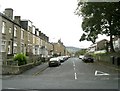
Living in BD20 6UT means being part of a small, densely populated residential cluster in the heart of Keighley, West Yorkshire. With 1,723 residents spread across 1.18 km², the area is characterised by its compact layout and historical roots. Originally a rural market town, Keighley evolved through the Industrial Revolution, becoming a hub for wool textile production. Today, BD20 6UT reflects a mature community, with a median age of 47 and a strong presence of adults aged 30–64. The area’s high home ownership rate (87%) and predominance of houses suggest a stable, long-term resident base. Daily life here is shaped by proximity to local amenities, including retail outlets, rail links, and schools. While the area lacks natural conservation designations, its practical connectivity and established infrastructure make it a functional choice for those prioritising convenience over rural scenery. The postcode’s small size means residents are likely to know their neighbours, fostering a close-knit environment. However, the average crime score of 61/100 warrants awareness of standard security measures. For buyers, BD20 6UT offers a blend of historical context and modern practicality in a well-served town.
- Area Type
- Postcode
- Area Size
- Not available
- Population
- 1723
- Population Density
- 1467 people/km²
The property market in BD20 6UT is dominated by owner-occupied homes, with 87% of residents living in properties they own. This high rate of home ownership contrasts with rental markets, indicating a community prioritising long-term investment over transient tenancy. The accommodation type is exclusively houses, which is uncommon in densely populated areas and suggests a focus on family homes rather than apartments or terraced housing. This configuration may appeal to buyers seeking space and privacy, though the small postcode area limits the availability of diverse property types. The high home ownership rate also implies limited availability of rental properties, potentially making it challenging for new buyers to enter the market without purchasing. Given the area’s compact size, property values may be influenced by proximity to local amenities such as schools and transport links. For those considering a move, the market reflects a settled, mature demographic with little turnover, offering stability but limited scope for speculative investment.
House Prices in BD20 6UT
No properties found in this postcode.
Energy Efficiency in BD20 6UT
Residents of BD20 6UT have access to a range of amenities within practical reach, including five retail outlets such as Farmfoods Eastwood, Sainsburys Keighley, and Asda Keighley. These stores provide essential shopping and grocery needs, supporting daily life without requiring long commutes. The area’s rail and metro stations also serve as gateways to broader leisure and employment opportunities. While specific parks or recreational spaces are not listed, the proximity to Keighley’s historical and commercial centres suggests a town with cultural and social venues. The mix of retail, transport, and educational facilities contributes to a functional lifestyle, though the absence of detailed information on dining or leisure spots means buyers may need to explore further afield for entertainment. Overall, the area’s amenities prioritise practicality, ensuring residents can meet daily needs without significant travel, though the character of the town’s leisure offerings remains underexplored in the data.
Amenities
Schools
The schools nearest to BD20 6UT include The Holy Family Catholic School, a primary institution, and The Holy Family Catholic School, a Voluntary Academy. Both share the same name but serve different educational stages, offering continuity for families. The presence of a primary school and an academy suggests a range of educational options, though the absence of Ofsted ratings means performance data is not available. For families, this mix could provide structured early education followed by a more specialised secondary phase. However, the lack of diversity in school types—only two institutions listed—may limit choices for parents seeking alternative educational approaches. The schools’ proximity to the area underscores their role in shaping the local community, though their specific academic outcomes remain unspecified. Buyers prioritising schools should consider visiting the institutions to assess their suitability for their children’s needs.
| Rank | School | Type | Entry gender | Ages |
|---|
Explore more schools in this area
Go to Schools tabDemographics
The community in BD20 6UT is predominantly composed of adults aged 30–64, with a median age of 47. This suggests a population skewed towards middle-aged individuals, likely reflecting long-term residency and stability. Home ownership is exceptionally high at 87%, indicating a strong preference for owning property over renting. The area is characterised by houses rather than flats, aligning with the demographic’s likely family-oriented needs. The predominant ethnic group is Asian_total, which influences the cultural and social fabric of the area. While no specific deprivation data is provided, the high home ownership rate and mature age profile may correlate with established economic stability. However, the average age and lack of younger residents could impact local services catering to children or retirees. The absence of detailed diversity metrics beyond the predominant group means the full scope of cultural variety remains unspecified. For prospective buyers, the demographic profile suggests a community focused on continuity, with limited turnover in housing stock.
Household Size
Accommodation Type
Tenure
Ethnic Group
Religion
Household Composition
Age
Household Deprivation
NS-SEC
Explore more demographic insights in this area
Go to Demographics tabPlanning
Planning Constraints
- Flood RiskPremium
- Ramsar Wetland SitesPremium
- Area of Outstanding Natural BeautyPremium
- Protected Nature ReservePremium
- Protected WoodlandPremium