Area Overview for BD15 0HR
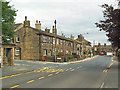
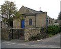
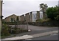
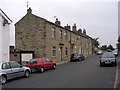
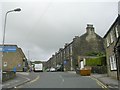
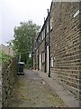
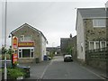
Photos of BD15 0HR


Area Information
Wilsden stands as a semi-rural dormitory village within the City of Bradford district, situated approximately six miles west of Bradford. This specific postcode cluster covers a compact 5,428 square metres of residential land, hosting a population of 1,697 people. The area's character is defined by its ancient Saxon roots, recorded in the Domesday Book of 1086 under the name 'Wilsedene'. Over centuries, it evolved from separate hamlets including Wilsden Hill and Lingbob into a community centred around historic farmhouses and textile-era mills. Today, the village operates as a commuter settlement while retaining a distinct local identity. You will find a neighbourhood that blends historic architecture, such as the 17th-century farmhouses in the conservation area, with modern housing developments. The core along Main Street remains the historic focal point, surrounded by isolated pockets of heritage sites like Wilsden Hill. Living in Wilsden offers a quiet pace of life that contrasts with the urban density of nearby Bradford. The village feels intimate, shaped by its history of farming and later industrialisation before transitioning to a modern residential hub. Residents enjoy proximity to the Hewenden viaduct and fruitful greenspaces that contribute to the area's tranquil atmosphere. This small residential cluster provides a grounded alternative to larger towns, earnestly serving those who prioritise a connection to history and nature over city centre convenience. The community within this postcode area is predominantly made up of adults between the ages of 30 and 64. The median age for residents is 47, indicating a mature demographic profile typical of established residential villages. A significant 74 per cent of households own their properties, suggesting a long-term settlement pattern where families and established professionals have roots in the locality. This high level of home ownership correlates with the primary accommodation type found in the area: houses. The housing is mostly single-family homes rather than flats or apartments, reflecting the village's expansion beyond its historic hamlet origins. The ethnic composition is largely White, mirroring the traditional character of West Yorkshire villages. This demographic makeup creates a stable environment where community stability often takes precedence. The presence of adults in the 30-to-64 age range suggests a mix of working professionals, retirees, and families with children. The low density of 312,620 people per square kilometre across this tiny area point to a very localised community feel. There is little indication of transient populations, allowing residents to build deep connections with their neighbours over decades. The age profile implies that services are geared towards established families and older adults, rather than students or young singles. Homes in BD15 0HR are characterised by a distinctly owner-occupied market. With 74 per cent of residents owning their homes, the local property scene is defined by stability rather than a high turnover of tenants. The vast majority of available properties are houses, fitting the historic evolution of the village from separate farmsteads to a cluster of residential estates. This high ownership rate means you are less likely to encounter a rental market for flats or apartments here. Instead, the inventory consists primarily of larger family homes, including converted mills and updated farmhouses within the conservation area. Buying a property here usually involves working with seasoned estate agents familiar with the nuances of the Wilsden area, particularly around Main Street and the outlying hamlets. The low population of 1,697 means that the local housing stock is limited and specific. Opportunities for purchase may arise occasionally as established homeowners move, potentially offering value to buyers seeking character over new builds. The area is not a hub for speculative investment but rather a place for those seeking a permanent residence. The density of 312,620 people per square kilometre across this 5,428 square metre area indicates that space is at a premium, making any available house a significant asset. You should expect prices to reflect the scarcity of new builds and the high demand for owned homes in this commuter village. Living in BD15 0HR requires a practical approach to connectivity and internet access due to its rural nature. The area receives mobile coverage with a score of 85 out of 100, reflecting excellent signal quality for most modern devices. This rating suggests strong network performance for daily communication and mobile data usage. By contrast, fixed broadband quality scores 55 out of 100, which categorises the connection as fair rather than excellent. Residents working from home can expect reliable internet speeds, though heavy-duty streaming or large file transfers might occasionally face latency compared to urban centres. This digital reality necessitates that you check specific provider packages before moving into a property. For physical travel, the village relies on road connections rather than direct rail services, as the former station at Harecroft closed in the modern era. Nearest rail hubs include Bingley, Crossflatts, and Saltaire stations, located several miles away. Nearby transport nodes like Damems, Ingrow West, and Oakworth further define the catchment area for bus services. The proximity to these locations means that reaching Bradford or other towns depends on scheduled coach and bus networks. You must plan your commute around these external connections, as there is no immediate train station within the immediate vicinity of the postcode. Daily life in Wilsden is enriched by a small selection of local amenities within practical reach. Retail options are centred on five key shops, including Co-op Wilsden, Co-op Cullingworth, and Morrisons Daily. These venues provide essential groceries and daily necessities without the need for long car journeys to larger town centres. For families with cars, rail connectivity is accessible via Bingley, Crossflatts, and Saltaire Railway Station, although these are a short drive away rather than immediate stops. The broader transport network includes access points at Damems, Ingrow West, and Oakworth, supporting regional travel via bus routes. While there is no mention of on-site leisure venues or parks in the immediate data, the presence of the Hewenden viaduct and the Conservation Area offers natural spaces for walking. The village society formed in 1970 to maintain community facilities, suggesting an active social fabric that operates on a neighbourhood level. Dining and entertainment likely rely on the historic former Mechanics' Institute and local pubs that have evolved from the pre-WWII era of over 50 shops. You will find that lifestyle here is self-contained but requires a car for access to wider cultural attractions. The presence of these specific retail and transport nodes ensures that basic needs are met while maintaining the village's semi-rural pace. Safety and environmental factors in BD15 0HR present a reassuring picture for prospective residents. The area passes all major planning constraint assessments, including flood risk, Ramsar wetland protection, Areas of Outstanding Natural Beauty, protected nature reserves, and protected woodland. Technical scores for these categories are zero, confirming the absence of statutory environmental restrictions in this specific cluster. This means you can build or renovate without fear of hidden ecological protections blocking development. Regarding personal security, crime risk assessments yield a score of 75 out of 100. A higher score here indicates a lower risk, meaning the area experiences below-average crime rates compared to national standards. Practical safety features extend beyond crime statistics; the lack of flood risk ensures properties are not threatened by water damage during heavy rains. The solid ground and absence of hazardous sites contribute to a stable living environment. There are no identified threats from industrial waste or protected wildlife zones that would impact daily life. The combination of these clear safety nets and low crime figures creates a secure backdrop for families. You can move here with confidence that the physical and social environment is stable and well-monitored by local authorities. Who typically lives in BD15 0HR and what is the community like?The resident population is predominantly adults aged 30 to 64, with a median age of 47. The community is highly stable, with 74 per cent of residents owning their homes. This creates a mature, established neighbourhood rather than a transient area. Is there easy railway access for commuters living in this postcode?Direct rail services are not available within the immediate area as the former Harecroft station is closed. Nearest stations like Bingley and Crossflatts are several miles away, requiring travel by car or bus to reach rail networks. Are there any environmental constraints like flood risk or protected land I should worry about?The area has a pass rating for all environmental assessments with zero risk scores for flood risk, wetland sites, and protected woodlands or nature reserves. There are no statutory planning constraints limiting development or building in this cluster. What shopping and retail options are available within walking distance?Residents have access to five key retail locations including Co-op Wilsden, Co-op Cullingworth, and Morrisons Daily. These provide essential daily shopping needs without requiring a long journey to larger city centre centres.
- Area Type
- Postcode
- Area Size
- 5428 m²
- Population
- 1697
- Population Density
- 3321 people/km²
Homes in BD15 0HR are characterised by a distinctly owner-occupied market. With 74 per cent of residents owning their homes, the local property scene is defined by stability rather than a high turnover of tenants. The vast majority of available properties are houses, fitting the historic evolution of the village from separate farmsteads to a cluster of residential estates. This high ownership rate means you are less likely to encounter a rental market for flats or apartments here. Instead, the inventory consists primarily of larger family homes, including converted mills and updated farmhouses within the conservation area. Buying a property here usually involves working with seasoned estate agents familiar with the nuances of the Wilsden area, particularly around Main Street and the outlying hamlets. The low population of 1,697 means that the local housing stock is limited and specific. Opportunities for purchase may arise occasionally as established homeowners move, potentially offering value to buyers seeking character over new builds. The area is not a hub for speculative investment but rather a place for those seeking a permanent residence. The density of 312,620 people per square kilometre across this 5,428 square metre area indicates that space is at a premium, making any available house a significant asset. You should expect prices to reflect the scarcity of new builds and the high demand for owned homes in this commuter village. Living in BD15 0HR requires a practical approach to connectivity and internet access due to its rural nature. The area receives mobile coverage with a score of 85 out of 100, reflecting excellent signal quality for most modern devices. This rating suggests strong network performance for daily communication and mobile data usage. By contrast, fixed broadband quality scores 55 out of 100, which categorises the connection as fair rather than excellent. Residents working from home can expect reliable internet speeds, though heavy-duty streaming or large file transfers might occasionally face latency compared to urban centres. This digital reality necessitates that you check specific provider packages before moving into a property. For physical travel, the village relies on road connections rather than direct rail services, as the former station at Harecroft closed in the modern era. Nearest rail hubs include Bingley, Crossflatts, and Saltaire stations, located several miles away. Nearby transport nodes like Damems, Ingrow West, and Oakworth further define the catchment area for bus services. The proximity to these locations means that reaching Bradford or other towns depends on scheduled coach and bus networks. You must plan your commute around these external connections, as there is no immediate train station within the immediate vicinity of the postcode. Daily life in Wilsden is enriched by a small selection of local amenities within practical reach. Retail options are centred on five key shops, including Co-op Wilsden, Co-op Cullingworth, and Morrisons Daily. These venues provide essential groceries and daily necessities without the need for long car journeys to larger town centres. For families with cars, rail connectivity is accessible via Bingley, Crossflatts, and Saltaire Railway Station, although these are a short drive away rather than immediate stops. The broader transport network includes access points at Damems, Ingrow West, and Oakworth, supporting regional travel via bus routes. While there is no mention of on-site leisure venues or parks in the immediate data, the presence of the Hewenden viaduct and the Conservation Area offers natural spaces for walking. The village society formed in 1970 to maintain community facilities, suggesting an active social fabric that operates on a neighbourhood level. Dining and entertainment likely rely on the historic former Mechanics' Institute and local pubs that have evolved from the pre-WWII era of over 50 shops. You will find that lifestyle here is self-contained but requires a car for access to wider cultural attractions. The presence of these specific retail and transport nodes ensures that basic needs are met while maintaining the village's semi-rural pace. Safety and environmental factors in BD15 0HR present a reassuring picture for prospective residents. The area passes all major planning constraint assessments, including flood risk, Ramsar wetland protection, Areas of Outstanding Natural Beauty, protected nature reserves, and protected woodland. Technical scores for these categories are zero, confirming the absence of statutory environmental restrictions in this specific cluster. This means you can build or renovate without fear of hidden ecological protections blocking development. Regarding personal security, crime risk assessments yield a score of 75 out of 100. A higher score here indicates a lower risk, meaning the area experiences below-average crime rates compared to national standards. Practical safety features extend beyond crime statistics; the lack of flood risk ensures properties are not threatened by water damage during heavy rains. The solid ground and absence of hazardous sites contribute to a stable living environment. There are no identified threats from industrial waste or protected wildlife zones that would impact daily life. The combination of these clear safety nets and low crime figures creates a secure backdrop for families. You can move here with confidence that the physical and social environment is stable and well-monitored by local authorities. Who typically lives in BD15 0HR and what is the community like?The resident population is predominantly adults aged 30 to 64, with a median age of 47. The community is highly stable, with 74 per cent of residents owning their homes. This creates a mature, established neighbourhood rather than a transient area. Is there easy railway access for commuters living in this postcode?Direct rail services are not available within the immediate area as the former Harecroft station is closed. Nearest stations like Bingley and Crossflatts are several miles away, requiring travel by car or bus to reach rail networks. Are there any environmental constraints like flood risk or protected land I should worry about?The area has a pass rating for all environmental assessments with zero risk scores for flood risk, wetland sites, and protected woodlands or nature reserves. There are no statutory planning constraints limiting development or building in this cluster. What shopping and retail options are available within walking distance?Residents have access to five key retail locations including Co-op Wilsden, Co-op Cullingworth, and Morrisons Daily. These provide essential daily shopping needs without requiring a long journey to larger city centre centres.
House Prices in BD15 0HR
Showing 21 properties
| Address | Type | Beds | Baths | Last Sale Price | Last Sale Date | |
|---|---|---|---|---|---|---|
| 11, Stonecross, Main Street, Wilsden, Bingley, BD15 0HR | Flat | 3 | 2 | £152,000 | Jul 2022 | |
| 4, Stonecross, Main Street, Wilsden, Bingley, BD15 0HR | Flat | 1 | 1 | £105,000 | Feb 2021 | |
| 161 Main Street, Wilsden, Bingley, BD15 0HR | Terraced | 2 | 1 | £102,000 | Feb 2020 | |
| 6, Stonecross, Main Street, Wilsden, Bingley, BD15 0HR | Flat | - | - | £125,000 | Mar 2018 | |
| 2, Stonecross, Main Street, Wilsden, Bingley, BD15 0HR | Flat | - | - | £125,000 | Jun 2017 | |
| 173A Main Street, Wilsden, Bingley, BD15 0HR | house | - | - | £225,000 | May 2017 | |
| 10, Stonecross, Main Street, Wilsden, Bingley, BD15 0HR | Maisonette | - | - | £180,000 | Jul 2011 | |
| 3, Stonecross, Main Street, Wilsden, Bingley, BD15 0HR | Flat | - | - | £104,950 | Apr 2011 | |
| 7, Stonecross, Main Street, Wilsden, Bingley, BD15 0HR | Flat | 1 | 1 | £105,000 | Jul 2010 | |
| 1, Stonecross, Main Street, Wilsden, Bingley, BD15 0HR | Flat | - | - | £150,000 | Oct 2009 |
Energy Efficiency in BD15 0HR
Daily life in Wilsden is enriched by a small selection of local amenities within practical reach. Retail options are centred on five key shops, including Co-op Wilsden, Co-op Cullingworth, and Morrisons Daily. These venues provide essential groceries and daily necessities without the need for long car journeys to larger town centres. For families with cars, rail connectivity is accessible via Bingley, Crossflatts, and Saltaire Railway Station, although these are a short drive away rather than immediate stops. The broader transport network includes access points at Damems, Ingrow West, and Oakworth, supporting regional travel via bus routes. While there is no mention of on-site leisure venues or parks in the immediate data, the presence of the Hewenden viaduct and the Conservation Area offers natural spaces for walking. The village society formed in 1970 to maintain community facilities, suggesting an active social fabric that operates on a neighbourhood level. Dining and entertainment likely rely on the historic former Mechanics' Institute and local pubs that have evolved from the pre-WWII era of over 50 shops. You will find that lifestyle here is self-contained but requires a car for access to wider cultural attractions. The presence of these specific retail and transport nodes ensures that basic needs are met while maintaining the village's semi-rural pace. Safety and environmental factors in BD15 0HR present a reassuring picture for prospective residents. The area passes all major planning constraint assessments, including flood risk, Ramsar wetland protection, Areas of Outstanding Natural Beauty, protected nature reserves, and protected woodland. Technical scores for these categories are zero, confirming the absence of statutory environmental restrictions in this specific cluster. This means you can build or renovate without fear of hidden ecological protections blocking development. Regarding personal security, crime risk assessments yield a score of 75 out of 100. A higher score here indicates a lower risk, meaning the area experiences below-average crime rates compared to national standards. Practical safety features extend beyond crime statistics; the lack of flood risk ensures properties are not threatened by water damage during heavy rains. The solid ground and absence of hazardous sites contribute to a stable living environment. There are no identified threats from industrial waste or protected wildlife zones that would impact daily life. The combination of these clear safety nets and low crime figures creates a secure backdrop for families. You can move here with confidence that the physical and social environment is stable and well-monitored by local authorities. Who typically lives in BD15 0HR and what is the community like?The resident population is predominantly adults aged 30 to 64, with a median age of 47. The community is highly stable, with 74 per cent of residents owning their homes. This creates a mature, established neighbourhood rather than a transient area. Is there easy railway access for commuters living in this postcode?Direct rail services are not available within the immediate area as the former Harecroft station is closed. Nearest stations like Bingley and Crossflatts are several miles away, requiring travel by car or bus to reach rail networks. Are there any environmental constraints like flood risk or protected land I should worry about?The area has a pass rating for all environmental assessments with zero risk scores for flood risk, wetland sites, and protected woodlands or nature reserves. There are no statutory planning constraints limiting development or building in this cluster. What shopping and retail options are available within walking distance?Residents have access to five key retail locations including Co-op Wilsden, Co-op Cullingworth, and Morrisons Daily. These provide essential daily shopping needs without requiring a long journey to larger city centre centres.
Amenities
Schools
| Rank | School | Type | Entry gender | Ages |
|---|
Explore more schools in this area
Go to Schools tabDemographics
The community within this postcode area is predominantly made up of adults between the ages of 30 and 64. The median age for residents is 47, indicating a mature demographic profile typical of established residential villages. A significant 74 per cent of households own their properties, suggesting a long-term settlement pattern where families and established professionals have roots in the locality. This high level of home ownership correlates with the primary accommodation type found in the area: houses. The housing is mostly single-family homes rather than flats or apartments, reflecting the village's expansion beyond its historic hamlet origins. The ethnic composition is largely White, mirroring the traditional character of West Yorkshire villages. This demographic makeup creates a stable environment where community stability often takes precedence. The presence of adults in the 30-to-64 age range suggests a mix of working professionals, retirees, and families with children. The low density of 312,620 people per square kilometre across this tiny area point to a very localised community feel. There is little indication of transient populations, allowing residents to build deep connections with their neighbours over decades. The age profile implies that services are geared towards established families and older adults, rather than students or young singles. Homes in BD15 0HR are characterised by a distinctly owner-occupied market. With 74 per cent of residents owning their homes, the local property scene is defined by stability rather than a high turnover of tenants. The vast majority of available properties are houses, fitting the historic evolution of the village from separate farmsteads to a cluster of residential estates. This high ownership rate means you are less likely to encounter a rental market for flats or apartments here. Instead, the inventory consists primarily of larger family homes, including converted mills and updated farmhouses within the conservation area. Buying a property here usually involves working with seasoned estate agents familiar with the nuances of the Wilsden area, particularly around Main Street and the outlying hamlets. The low population of 1,697 means that the local housing stock is limited and specific. Opportunities for purchase may arise occasionally as established homeowners move, potentially offering value to buyers seeking character over new builds. The area is not a hub for speculative investment but rather a place for those seeking a permanent residence. The density of 312,620 people per square kilometre across this 5,428 square metre area indicates that space is at a premium, making any available house a significant asset. You should expect prices to reflect the scarcity of new builds and the high demand for owned homes in this commuter village. Living in BD15 0HR requires a practical approach to connectivity and internet access due to its rural nature. The area receives mobile coverage with a score of 85 out of 100, reflecting excellent signal quality for most modern devices. This rating suggests strong network performance for daily communication and mobile data usage. By contrast, fixed broadband quality scores 55 out of 100, which categorises the connection as fair rather than excellent. Residents working from home can expect reliable internet speeds, though heavy-duty streaming or large file transfers might occasionally face latency compared to urban centres. This digital reality necessitates that you check specific provider packages before moving into a property. For physical travel, the village relies on road connections rather than direct rail services, as the former station at Harecroft closed in the modern era. Nearest rail hubs include Bingley, Crossflatts, and Saltaire stations, located several miles away. Nearby transport nodes like Damems, Ingrow West, and Oakworth further define the catchment area for bus services. The proximity to these locations means that reaching Bradford or other towns depends on scheduled coach and bus networks. You must plan your commute around these external connections, as there is no immediate train station within the immediate vicinity of the postcode. Daily life in Wilsden is enriched by a small selection of local amenities within practical reach. Retail options are centred on five key shops, including Co-op Wilsden, Co-op Cullingworth, and Morrisons Daily. These venues provide essential groceries and daily necessities without the need for long car journeys to larger town centres. For families with cars, rail connectivity is accessible via Bingley, Crossflatts, and Saltaire Railway Station, although these are a short drive away rather than immediate stops. The broader transport network includes access points at Damems, Ingrow West, and Oakworth, supporting regional travel via bus routes. While there is no mention of on-site leisure venues or parks in the immediate data, the presence of the Hewenden viaduct and the Conservation Area offers natural spaces for walking. The village society formed in 1970 to maintain community facilities, suggesting an active social fabric that operates on a neighbourhood level. Dining and entertainment likely rely on the historic former Mechanics' Institute and local pubs that have evolved from the pre-WWII era of over 50 shops. You will find that lifestyle here is self-contained but requires a car for access to wider cultural attractions. The presence of these specific retail and transport nodes ensures that basic needs are met while maintaining the village's semi-rural pace. Safety and environmental factors in BD15 0HR present a reassuring picture for prospective residents. The area passes all major planning constraint assessments, including flood risk, Ramsar wetland protection, Areas of Outstanding Natural Beauty, protected nature reserves, and protected woodland. Technical scores for these categories are zero, confirming the absence of statutory environmental restrictions in this specific cluster. This means you can build or renovate without fear of hidden ecological protections blocking development. Regarding personal security, crime risk assessments yield a score of 75 out of 100. A higher score here indicates a lower risk, meaning the area experiences below-average crime rates compared to national standards. Practical safety features extend beyond crime statistics; the lack of flood risk ensures properties are not threatened by water damage during heavy rains. The solid ground and absence of hazardous sites contribute to a stable living environment. There are no identified threats from industrial waste or protected wildlife zones that would impact daily life. The combination of these clear safety nets and low crime figures creates a secure backdrop for families. You can move here with confidence that the physical and social environment is stable and well-monitored by local authorities. Who typically lives in BD15 0HR and what is the community like?The resident population is predominantly adults aged 30 to 64, with a median age of 47. The community is highly stable, with 74 per cent of residents owning their homes. This creates a mature, established neighbourhood rather than a transient area. Is there easy railway access for commuters living in this postcode?Direct rail services are not available within the immediate area as the former Harecroft station is closed. Nearest stations like Bingley and Crossflatts are several miles away, requiring travel by car or bus to reach rail networks. Are there any environmental constraints like flood risk or protected land I should worry about?The area has a pass rating for all environmental assessments with zero risk scores for flood risk, wetland sites, and protected woodlands or nature reserves. There are no statutory planning constraints limiting development or building in this cluster. What shopping and retail options are available within walking distance?Residents have access to five key retail locations including Co-op Wilsden, Co-op Cullingworth, and Morrisons Daily. These provide essential daily shopping needs without requiring a long journey to larger city centre centres.
Household Size
Accommodation Type
Tenure
Ethnic Group
Religion
Household Composition
Age
Household Deprivation
NS-SEC
Explore more demographic insights in this area
Go to Demographics tabPlanning
Planning Constraints
- Flood RiskPremium
- Ramsar Wetland SitesPremium
- Area of Outstanding Natural BeautyPremium
- Protected Nature ReservePremium
- Protected WoodlandPremium