Area Overview for BD12 0YJ
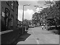
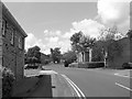
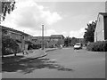
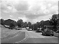
Photos of BD12 0YJ
Area Information
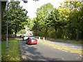
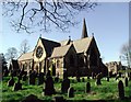
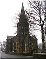
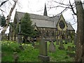
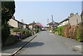
Living in BD12 0YJ means inhabiting a small, tightly knit residential cluster in West Yorkshire, just 4.5 miles south of Bradford city centre. With a population of 1,525, this area retains a quiet, rural character despite its proximity to urban hubs. The settlement traces its roots to the Norman Conquest and the 17th-century Moravian community, which left a legacy of listed buildings and conservation areas. Today, the area is defined by well-spaced farmsteads, cottages, and historic structures along Lower Wyke Lane, creating a distinct sense of place. Residents benefit from proximity to Bradford’s amenities while enjoying a slower pace of life. The area’s small size means a strong sense of community, with local landmarks like the Red Lion public house and remnants of early 19th-century infrastructure. For those seeking a blend of history and modern convenience, BD12 0YJ offers a unique balance, with its low flood risk and accessible transport links.
- Area Type
- Postcode
- Area Size
- Not available
- Population
- 1525
- Population Density
- 3548 people/km²
The property market in BD12 0YJ is dominated by owner-occupied homes, with 76% of residents living in houses rather than flats or apartments. This reflects a housing stock that prioritises single-family residences, likely with larger gardens and traditional layouts. Given the area’s small size and conservation status, the market is likely limited in scale, with fewer new developments and a focus on maintaining historic character. Buyers should expect a mix of older properties with listed buildings, such as the Moravian church and former boarding school, alongside more modern homes. The high home ownership rate suggests limited rental availability, making this area more attractive to those seeking long-term stability. For buyers, the challenge lies in navigating the small pool of listings, but the area’s unique heritage and low environmental risk offer compelling reasons to invest.
House Prices in BD12 0YJ
No properties found in this postcode.
Energy Efficiency in BD12 0YJ
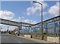
Daily life in BD12 0YJ is shaped by its mix of historic charm and practical amenities. Within practical reach are five retail outlets, including Tesco Low, Co-op Wibsey, and Morrisons Bankfoot, ensuring residents have access to essential shopping. The area’s rail network, with stations like Low Moor and Bradford Interchange, provides easy links to Bradford’s urban centres, where more dining and leisure options are available. The conservation area status means a focus on preserving heritage, with listed buildings and green spaces contributing to a tranquil environment. While the area lacks large parks, its rural character and proximity to Bradford offer a balance of quiet living and urban accessibility. The Red Lion public house and historic farmsteads add to the local identity, making it ideal for those who value both community and convenience.
Amenities
Schools
The only school explicitly listed near BD12 0YJ is Netherlands Avenue School and Community Nursery, a special school serving children with specific educational needs. No Ofsted rating is provided, so its performance cannot be assessed directly. The presence of a special school suggests the area may cater to families with children requiring tailored support, though it does not indicate the availability of mainstream primary or secondary education. Parents seeking a broader range of schools may need to look beyond the immediate vicinity. The school’s role as a community nursery also implies a focus on early years education and local integration. Families should consider proximity to other schools in nearby wards, such as those in Bradford, when planning their move.
| Rank | School | Type | Entry gender | Ages |
|---|
Explore more schools in this area
Go to Schools tabDemographics
BD12 0YJ’s population is predominantly adults aged 30–64, with a median age of 47. This suggests a mature, stable community, likely with long-term residents. Home ownership is high at 76%, indicating a strong presence of owner-occupied properties, which often correlates with lower turnover and a sense of permanence. The area is characterised by houses rather than flats, reflecting a preference for single-family dwellings. The predominant ethnic group is White, though no specific diversity statistics are provided. The absence of deprivation data means no direct commentary on socioeconomic challenges, but the high home ownership and age profile suggest a relatively affluent, settled demographic. The area’s historical roots as a Moravian settlement and its conservation status further shape its cultural and social fabric, contributing to a cohesive, low-density lifestyle.
Household Size
Accommodation Type
Tenure
Ethnic Group
Religion
Household Composition
Age
Household Deprivation
NS-SEC
Explore more demographic insights in this area
Go to Demographics tabPlanning
Planning Constraints
- Flood RiskPremium
- Ramsar Wetland SitesPremium
- Area of Outstanding Natural BeautyPremium
- Protected Nature ReservePremium
- Protected WoodlandPremium