Area Overview for BD12 0RS
Photos of BD12 0RS
Area Information
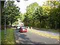
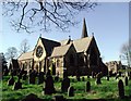
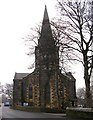
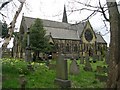
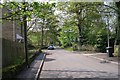
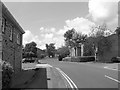
Living in BD12 0RS offers a distinct experience within the Wyke Ward of the Bradford District. This specific postcode covers a small residential cluster covering 568 m², situated approximately 4.5 miles south of Bradford city centre. The area has deep historical roots, originating as a settlement documented from the Norman Conquest and the Domesday Survey. Later evolution in the 17th and 18th centuries saw the hamlet develop along Lower Wyke Lane, characterised by farmsteads, a manor house, and a significant Moravian settlement. The local character remains defined by designated conservation status, which protects Moravian buildings, including a church and a former girls' boarding school. The area is populated by 1324 residents, creating a tight-knit community atmosphere rather than a sprawling suburb. You will find yourself in an environment where history meets modern convenience, blending the quiet nature of a linear hamlet with access to key transport routes. The combination of historic architecture and a settled population creates a stable living environment for those seeking a home with a clear narrative and established boundaries within the broader Bradford unitary authority.
- Area Type
- Postcode
- Area Size
- 568 m²
- Population
- 1324
- Population Density
- 2332997 people/km²
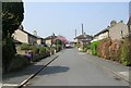
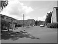
The property market in BD12 0RS is characterised by a dominance of owner-occupied housing stock. A notable 76% of homes are owned outright or with a mortgage rather than rented, reflecting a traditionally stable residential environment. The accommodation type for the area is strictly Houses, meaning the housing stock comprises standing houses rather than flats or apartments. This composition suggests a market geared towards families and retirees looking for space and permanence. Given that BD12 0RS is a small residential cluster with a population of 1324 people, the numbers of available properties will be limited. Buyers looking at this specific postcode should expect a competitive market for the available houses. The high level of home ownership indicates that individuals treat these properties as long-term assets. Those considering homes in BD12 0RS are typically entering a market where the primary stock consists of traditional houses situated within defined conservation areas. The lack of rented sector dominance means that purchasing power and local investment have shaped the current housing stock, resulting in a community where residents generally stay put.
House Prices in BD12 0RS
Showing 5 properties
| Address | Type | Beds | Baths | Last Sale Price | Last Sale Date | |
|---|---|---|---|---|---|---|
| 10 Wilson Fold, Bradford, BD12 0RS | Terraced | 2 | 1 | £113,700 | Jul 2025 | |
| 11 Wilson Fold, Bradford, BD12 0RS | house | - | - | £62,000 | Jul 2020 | |
| 12 Wilson Fold, Bradford, BD12 0RS | Terraced | 2 | 1 | £77,000 | Jan 2019 | |
| 9 Wilson Fold, Bradford, BD12 0RS | Terraced | 1 | 1 | £38,000 | Mar 2018 | |
| 14 Wilson Fold, Bradford, BD12 0RS | house | - | - | £70,000 | Oct 2006 |
Energy Efficiency in BD12 0RS
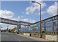
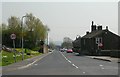
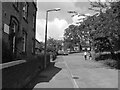
Living in BD12 0RS provides direct access to practical amenities that form the backbone of daily life. Within a short radius, you can shop at five retail locations, specifically including Tesco Low, Asda Wyke, and Morrisons Daily Bradford. These supermarkets offer groceries and daily essentials without the need for a long journey. For travel, the area is served by five notable rail stations, most prominently Low Moor Railway Station, Bradford Interchange Railway Station, and Bradford Foster Square Railway Station. These transport hubs facilitate easy trips to the wider region, provided you own a car or can access local bus services. The area's historical character adds to the lifestyle value, with Lower Wyke being a designated conservation area. You can walk past Moravian settlement buildings, a church, and remnants of early farmsteads and the manor house enjoying the designated conservation area status. The presence of the Red Lion public house, with a license transferred circa 1856, offers a historic social gathering spot. Residents enjoy the quiet atmosphere of Lower Wyke Green and the preservation of historic sites while maintaining easy access to modern shopping and transport networks in the surrounding Bradford District.
Amenities
Schools
Families living in BD12 0RS have access to specific educational facilities that cater to the needs of the local community. The nearest school option is Low Moor CofE Primary School, which operates as a primary education provider. This school holds a Good Ofsted rating, indicating a standard of education that meets regulatory expectations. With a population density and median age of 47, the demand for primary schooling is present but specific, fitting the age profile of the area. The presence of a CofE primary school offers a faith-based educational option for local families seeking this specific curriculum. While secondary school data is not provided for the immediate vicinity, the local infrastructure supports primary education needs effectively. For children regarding your household, this means they can access a recognised primary school with a positive rating without needing to travel far. The proximity of Low Moor CofE Primary School ensures that the older child population in the 30 to 64 age range has a local option for their offspring or younger family members. This single school option shapes the educational landscape for residents in this small residential cluster.
| Rank | School | Type | Entry gender | Ages |
|---|
Explore more schools in this area
Go to Schools tabDemographics
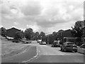
The community in BD12 0RS is defined by a stable and mature population profile. The median age across this area is 47 years, indicating a resident base that is significantly older than the national average for younger families. Most commonly, the population falls into the adults category spanning 30 to 64 years, suggesting a focus on established households rather than young single professionals. Home ownership stands at 76%, which is a strong indicator of financial stability and long-term settlement within the area. This high rate reflects the presence of families and individuals who have put down roots over many decades. Predominantly, the ethnic group in this locality is White, contributing to a homogenous community dynamic. The accommodation type is exclusively Houses, meaning you will not find flats or high-rise blocks or multi-story dwellings in this specific residential cluster. With a population density that, while high in statistical terms due to the small geographic footprint of the postcode, supports a functional local living, the area lacks the constraints of protected nature reserves or woodlands that might limit development. The landscape consists primarily of farmsteads and cottages, supporting the predominantly White demographic and the specific age range of adults living here.
Household Size
Accommodation Type
Tenure
Ethnic Group
Religion
Household Composition
Age
Household Deprivation
NS-SEC
Explore more demographic insights in this area
Go to Demographics tabPlanning
Planning Constraints
- Flood RiskPremium
- Ramsar Wetland SitesPremium
- Area of Outstanding Natural BeautyPremium
- Protected Nature ReservePremium
- Protected WoodlandPremium