Area Overview for BD1 5RE
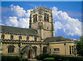
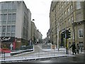
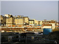
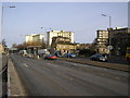
Photos of BD1 5RE


Area Information
Living in BD1 5RE means being part of a small, tightly knit residential cluster in the heart of Bradford, West Yorkshire. With a population of just 1,114, this area is defined by its urban density and proximity to the city’s central infrastructure. The postcode sits within the City Ward, a historically significant electoral area that forms the core of Bradford’s administrative and cultural life. Daily life here is shaped by the surrounding urban environment, with easy access to retail, transport, and essential services. The area’s compact size means residents are within practical reach of major amenities, from supermarkets to railway stations. While the population is small, the community is anchored by its proximity to Bradford’s landmarks and institutions, making it a convenient base for those who work or study in the city. However, the area’s character is one of practicality over grandeur, with a focus on accessibility rather than expansive open spaces. For buyers, BD1 5RE offers a compact, functional living environment in a well-connected part of Bradford.
- Area Type
- Postcode
- Area Size
- Not available
- Population
- 1114
- Population Density
- 6756 people/km²
The property market in BD1 5RE is characterised by a very low rate of home ownership—just 8% of households are owner-occupied. This suggests that the area is not a typical buyer’s market but one dominated by rental properties and other forms of tenure. The accommodation type is almost exclusively flats, which aligns with the urban, high-density nature of the postcode. For buyers, this means the housing stock is limited to smaller, purpose-built units rather than detached or semi-detached homes. The small population and compact size of the area further indicate that property availability is constrained, with little scope for expansion. Those considering purchase here should factor in the challenges of limited ownership opportunities and the potential for higher rental demand. The market is likely to appeal more to investors or those seeking short-term tenancy options than to first-time buyers seeking long-term ownership.
House Prices in BD1 5RE
Showing 7 properties
| Address | Type | Beds | Baths | Last Sale Price | Last Sale Date | |
|---|---|---|---|---|---|---|
| Flat 426, Olicana House, Chapel Street, Bradford, BD1 5RE | Flat | - | - | - | - | |
| Flat 11, Olicana House, Chapel Street, Bradford, BD1 5RE | Flat | - | - | - | - | |
| Flat 326, Olicana House, Chapel Street, Bradford, BD1 5RE | Flat | - | - | - | - | |
| Flat 325, Olicana House, Chapel Street, Bradford, BD1 5RE | Flat | - | - | - | - | |
| Flat 125, Olicana House, Chapel Street, Bradford, BD1 5RE | Flat | - | - | - | - | |
| Flat 425, Olicana House, Chapel Street, Bradford, BD1 5RE | Flat | - | - | - | - | |
| Flat 226, Olicana House, Chapel Street, Bradford, BD1 5RE | Flat | - | - | - | - |
Energy Efficiency in BD1 5RE
The lifestyle in BD1 5RE is shaped by its proximity to essential amenities, including five retail venues such as Sainsburys Bradford, Lidl Undercliffe, and Tesco Bradford. These stores provide convenient access to groceries and everyday essentials, reducing the need for long trips. The area’s transport links, particularly the nearby railway stations, enhance mobility for shopping, leisure, and work. While there is no mention of parks or recreational spaces in the data, the urban setting suggests that residents may rely on nearby public spaces or community facilities. The presence of multiple supermarkets and transport hubs indicates a practical, service-oriented lifestyle, prioritising convenience over expansive leisure options. For those who value accessibility and ease of access to city amenities, BD1 5RE offers a compact, functional environment.
Amenities
Schools
The schools near BD1 5RE include St Mary’s Catholic Primary School, a primary institution serving local families, and the Training and Skills Centre, a special school with an Ofsted rating of inadequate. This mix of school types means families have access to both mainstream primary education and specialist provision for students with specific needs. However, the inadequate rating at the Training and Skills Centre raises concerns about the quality of education available for those requiring alternative learning environments. For parents, the availability of a primary school is a positive, but the lack of high-performing special schools may be a drawback. The limited range of educational options reflects the area’s small size and focus on basic services rather than comprehensive schooling infrastructure.
| Rank | School | Type | Entry gender | Ages |
|---|
Explore more schools in this area
Go to Schools tabDemographics
The community in BD1 5RE is predominantly middle-aged, with a median age of 47 and the majority of residents falling within the 30-64 age range. Home ownership is exceptionally low at 8%, suggesting that most households are either rented or in other forms of tenure. The accommodation type is almost exclusively flats, reflecting the area’s urban, high-density layout. The predominant ethnic group is White, though specific data on diversity or deprivation is not provided. This demographic profile indicates a population that may be more established, with fewer young families or transient residents. The low home ownership rate could imply limited long-term investment in property, which may affect market dynamics. For prospective buyers, understanding the age profile and tenure patterns is key to assessing the area’s suitability for different household needs.
Household Size
Accommodation Type
Tenure
Ethnic Group
Religion
Household Composition
Age
Household Deprivation
NS-SEC
Explore more demographic insights in this area
Go to Demographics tabPlanning
Planning Constraints
- Flood RiskPremium
- Ramsar Wetland SitesPremium
- Area of Outstanding Natural BeautyPremium
- Protected Nature ReservePremium
- Protected WoodlandPremium