Area Overview for Wilton
Photos of Wilton


Area Information
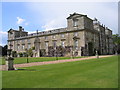
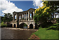
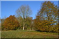
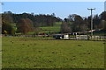
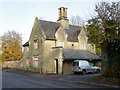
Wilton is a civil parish in England covering an area of 10.6 km². This specific boundary defines the limits of the settlement. The location offers a defined sense of place within the wider countryside. Living in Wilton means you occupy a space with clear geographical markers. The total area size influences how spread out the community appears to be. Residents know the exact extent of their neighbourhood. You can walk the entire extent of the parish in a reasonable time. This compact size supports a tight-knit feel compared to larger towns. The area functions as a distinct unit rather than a scattered collection of villages. Daily life revolve around this specific 10.6 km² footprint. You understand where the boundaries lie and what encompasses your home. The civil parish structure provides a tangible identity for the locality. It is a place where residents recognise local landmarks within these specific limits. The size of the area directly impacts how much green space exists around each property. You would know the exact distance to the edge of the parish. This consistency helps establish a predictable daily routine for everyone. There is no ambiguity about where you are when you call this home. The defined nature of the parish creates a stable environment for long-term residence.
- Area Type
- Parish
- Area Size
- 10.6 km²
- Population
- Not available
- Population Density
- Not available
Demographics
The community in Wilton has a median age of 70 years. This figure indicates that the population skews significantly older than the national average. Most residents fall into the age category marked as 'Age: Total' in the dataset. You should expect to find a higher proportion of elderly residents compared to working-age parents. This demographic profile shapes the local culture and service needs. Home ownership stands at 63% of all households in the parish. The majority of people who live here own their property outright or with a mortgage. Renting represents the minority of accommodation arrangements within Wilton. The high ownership rate suggests long-term stability for the community. Fewer people move in and out frequently compared to areas with lower ownership levels. This stability contributes to the older age profile observed in the data. Household composition reflects the needs of an older population. You will find more empty nesters or retirees than young families with children. Accommodation types suit this demographic mix primarily. Diversity metrics in the data are not explicitly broken down for specific groups. The overall picture remains focused on age and tenure. You must account for this when expecting services or neighbourhood activities. The demographic reality is a mature community with established residents. Planning for new developments requires sensitivity to these specific population needs. The 63% ownership rate is a key indicator of this market dynamic.
Household Size
Accommodation Type
Tenure
Ethnic Group
Religion
Household Composition
Age
Household Deprivation
NS-SEC
Explore more demographic insights in this area
Go to Demographics tabPlanning
Planning Constraints
- Flood RiskPremium
- Ramsar Wetland SitesPremium
- Area of Outstanding Natural BeautyPremium
- Protected Nature ReservePremium
- Protected WoodlandPremium