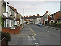
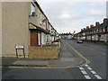
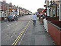
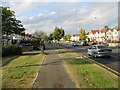
Area Overview for Swindon (Swindon)
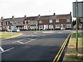
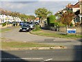
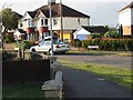
Photos of Swindon (Swindon)

Area Information
Swindon operates as a unitary authority district within the ceremonial county of Wiltshire, functioning independently from the wider council structure. This administrative separation means the local government handles planning, education, and housing directly. Although the borough covers a relatively compact area of 39.5 square kilometres, it supports a population of 51,516 residents. You will find this location in the north-easterly part of South West England, centred on the town of Swindon itself. The density stands at 1,305 people per square kilometre, which creates a residential environment that feels contained yet established. Living in Swindon offers a distinct lifestyle defined by its local authority status and its position within the broader West of England region. The area combines the governance of a borough with the geography of a town. You can expect a community structured by specific local responsibilities rather than being absorbed into a larger county council system. This setup often leads to more direct local engagement from the government. The population size suggests a neighbourhood where public services remain accessible without the vast scale of major metropolitan centres. Homes in Swindon cater to this specific demographic scale.
- Area Type
- District/Borough
- Area Size
- 39.5 km²
- Population
- 51516
- Population Density
- 1305 people/km²
Demographics
The community profile reflects a population with a significant proportion of older residents. Your analysis of the age data shows a median age of 70 years. This figure places Swindon among settlements with a notably mature demographic structure. The most common age range recorded simply as 'Age: Total' implies a broad distribution weighted heavily toward seniors. You will find that 64 per cent of households are owner-occupied. This high rate of ownership indicates a settled community where many residents have built long-term ties to their local properties. Private ownership dominates the housing landscape compared to private renting or social housing sectors. While specific household composition and predominant ethnic group data are not quantified in the available records, the high ownership percentage shapes the character of the area. Deprivation levels are not explicitly detailed in the current dataset, so you cannot assess poverty concentrations directly from these figures. However, the age profile and ownership rates suggest stability. Living in this area involves engaging with a community where decisions often reflect the interests of an older demographic. Understanding these figures helps you gauge the typical neighbour and local needs you might encounter.