Area Overview for Wellington
Photos of Wellington


Area Information
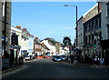
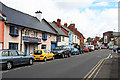
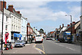
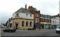
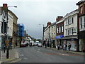
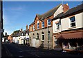
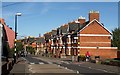
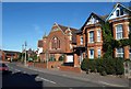
Wellington is a historic town in Somerset, South West England, covering an area of 8.7 km². It sits on the historic trade route between Bristol and Exeter, a location that has defined its character since it was granted town status by royal charter in 1215. The community currently has a population of 4,419 people, creating a relatively compact living environment. This demographic size and geographical footprint mean that daily life here is shaped by a sense of history combined with practical transport links to nearby cities. The town's identity is closely tied to its past as an administrative centre and its association with the Duke of Wellington, whose legacy remains visible in local landmarks such as the Wellesley Cinema and Wellesley Park. For those considering living in Wellington, the limited scale of the settlement offers a manageable distance from urban amenities while retaining a distinct local character. The settlement's establishment in the 13th century has left a physical footprint that new residents encounter regularly. Daily routines likely involve using the historic High Street, which features The Squirrel, the home of the Town Council since 1982. Although modern economic drivers are not fully detailed in current records, the town functioned historically as a centre for trade and was associated with the woollen industry. You might find yourself navigating streets lined with memorials, such as the one for Sir John Popham at St John's Parish Church. The balance between its medieval origins and contemporary necessities like reliable internet connectivity defines the practical reality of settling here.
- Area Type
- Unitary Electoral Division
- Area Size
- 8.7 km²
- Population
- 4419
- Population Density
- 511 people/km²
Demographics
The community profile of Wellington reflects a settled population with a high degree of stability. A significant portion of the residents are older adults, with the median age recorded at 70 years. This age structure suggests a town where many families may have long roots or where retirement has played a major role in shaping the demographic landscape. You might expect to see a demographic skew towards older individuals rather than a young, transient workforce. Home ownership is high within the area, with 66% of homes owned outright or with a mortgage. This figure indicates that most residents have a stake in the local property market, unlike areas dominated by short-term tenancies. The household composition and accommodation types in Wellington support this pattern of stability. The data indicates a standard distribution of housing stock suitable for a town of its size. While specific details on ethnic diversity or religious affiliation are not broken down in the current records, the town's history and location in Somerset suggest a community with traditional regional characteristics. For those looking to understand who lives in Wellington, the high ownership rate and median age point towards a mature community. This does not necessarily mean the town is devoid of activity, but rather that its rhythm is set by generations of families and individuals who have remained in Somerset West and Taunton. The stability of the population means that local services are likely accustomed to serving a consistent client base. When you consider the demographics, you are entering a market where long-term residency is the norm rather than the exception.
Household Size
Accommodation Type
Tenure
Ethnic Group
Religion
Household Composition
Age
Household Deprivation
NS-SEC
Explore more demographic insights in this area
Go to Demographics tabPlanning
Planning Constraints
- Flood RiskPremium
- Ramsar Wetland SitesPremium
- Area of Outstanding Natural BeautyPremium
- Protected Nature ReservePremium
- Protected WoodlandPremium
- Crime RiskPremium