Area Overview for TR7 3EQ
Photos of TR7 3EQ
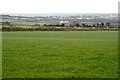
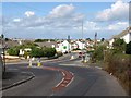
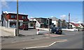
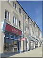
5 photos from this area
Area Information
Key information about the TR7 3EQ including its size, population, and administrative classification.
- Area Type
- Postcode
- Area Size
- 8.0 hectares
- Population
- 1323
- Population Density
- 2934 people/km²
House Prices in TR7 3EQ
48
Properties
£271,542
Average Sold Price
£25,000
Lowest Price
£415,000
Highest Price
Showing 48 properties
| Address | Type | Beds | Baths | Last Sale Price | Last Sale Date | |
|---|---|---|---|---|---|---|
| 126 Henver Road, Newquay, TR7 3EQ | Semi-detached | 4 | 2 | £415,000 | Dec 2025 | |
| 144 Henver Road, Newquay, TR7 3EQ | Semi-detached | 4 | 2 | £415,000 | Nov 2023 | |
| 150 Henver Road, Newquay, TR7 3EQ | Bungalow | 4 | 1 | £375,000 | Oct 2023 | |
| 146 Henver Road, Newquay, TR7 3EQ | Semi-detached | 4 | 2 | £365,000 | Jul 2020 | |
| 134 Henver Road, Newquay, TR7 3EQ | Semi-detached | 3 | - | £275,000 | Nov 2017 | |
| 148 Henver Road, Newquay, TR7 3EQ | Bungalow | - | - | £205,000 | Jun 2014 | |
| 154 Henver Road, Newquay, TR7 3EQ | house | 2 | - | £156,000 | Feb 2014 | |
| 152A Henver Road, Newquay, TR7 3EQ | Detached | 2 | - | £196,000 | Apr 2013 | |
| 116 Henver Road, Newquay, TR7 3EQ | hotel | - | - | £320,000 | Mar 2008 | |
| 120 Henver Road, Newquay, TR7 3EQ | Semi-detached | - | - | £265,000 | Aug 2007 |
Page 1 of 5
Energy Efficiency in TR7 3EQ
Amenities
Schools
| Rank | School | Type | Entry gender | Ages |
|---|
Explore more schools in this area
Go to Schools tabDemographics
Household Size
Two person
most common
Accommodation Type
Houses
most common
Tenure
70
majority
Ethnic Group
White
most common
Religion
N/A
most common
Household Composition
N/A
most common
Age
47
median
Adults (30-64 years)
most common
Household Deprivation
N/A
with no deprivation
NS-SEC
29
in Lower managerial occupations
Explore more demographic insights in this area
Go to Demographics tabPlanning
Planning Constraints
- Flood RiskPremium
- Ramsar Wetland SitesPremium
- Area of Outstanding Natural BeautyPremium
- Protected Nature ReservePremium
- Protected WoodlandPremium