Area Overview for TQ4 6BU
Photos of TQ4 6BU
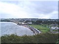
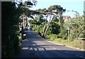
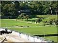
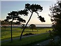
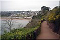
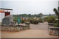
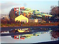
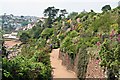
113 photos from this area
Area Information
Key information about the TQ4 6BU including its size, population, and administrative classification.
- Area Type
- Postcode
- Area Size
- 8.2 hectares
- Population
- 1391
- Population Density
- 3306 people/km²
House Prices in TQ4 6BU
89
Properties
£330,992
Average Sold Price
£285,000
Lowest Price
£390,000
Highest Price
Showing 89 properties
| Address | Type | Beds | Baths | Last Sale Price | Last Sale Date | |
|---|---|---|---|---|---|---|
| 24 Youngs Park Road, Paignton, TQ4 6BU | Semi-detached | 4 | 2 | £345,000 | Dec 2024 | |
| 46 Youngs Park Road, Paignton, TQ4 6BU | Semi-detached | 6 | 2 | £390,000 | Mar 2019 | |
| 40 Youngs Park Road, Paignton, TQ4 6BU | Terraced | 5 | 2 | £350,000 | Jan 2018 | |
| 50 Youngs Park Road, Paignton, TQ4 6BU | Detached | 4 | 3 | £285,000 | Aug 2016 | |
| 36 Youngs Park Road, Paignton, TQ4 6BU | Terraced | - | - | £315,950 | Jan 2008 | |
| 26 Youngs Park Road, Paignton, TQ4 6BU | house | - | - | £300,000 | Apr 2007 | |
| Apartment 2, 44 Youngs Park Road, Paignton, TQ4 6BU | Flat | 2 | 2 | - | - | |
| Flat 6, 38 Youngs Park Road, Paignton, TQ4 6BU | Flat | 2 | 1 | - | - | |
| Flat 5, 38 Youngs Park Road, Paignton, TQ4 6BU | Flat | 1 | 1 | - | - | |
| First Floor And Second Floor Flat, 22C Youngs Park Road, Paignton, TQ4 6BU | Maisonette | 3 | - | - | - |
Page 1 of 9
Energy Efficiency in TQ4 6BU
Amenities
Schools
| Rank | School | Type | Entry gender | Ages |
|---|
Explore more schools in this area
Go to Schools tabDemographics
Household Size
One person
most common
Accommodation Type
Flats
most common
Tenure
59
majority
Ethnic Group
White
most common
Religion
N/A
most common
Household Composition
N/A
most common
Age
47
median
Adults (30-64 years)
most common
Household Deprivation
N/A
with no deprivation
NS-SEC
24
in Lower managerial occupations
Explore more demographic insights in this area
Go to Demographics tabPlanning
Planning Constraints
- Flood RiskPremium
- Ramsar Wetland SitesPremium
- Area of Outstanding Natural BeautyPremium
- Protected Nature ReservePremium
- Protected WoodlandPremium