Area Overview for Temple Cloud with Cameley
Photos of Temple Cloud with Cameley
Area Information
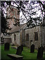
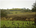
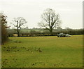
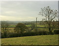
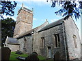
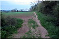
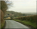
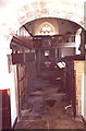
Living in Temple Cloud with Cameley offers a distinct rural setting situated on the northern slopes of the Mendip Hills. This civil parish covers an area size of 6.6 km² and sits within the Chew Valley in Bath and North East Somerset. The village of Temple Cloud lies directly on the A37 road, placing you just 10 miles south of Bristol and a convenient 5 miles from Midsomer Norton. Cameley, your neighbouring village, rests along the Cam Brook. The name Temple Cloud links to Knights Templar tenure around 1200, creating a community with deep historical roots visible in its architecture. You will find historic sites such as the Grade II-listed Old Court, built in 1857, and the Temple Inn pub. Daily life revolves around a quiet countryside feel with commanding views. Community facilities include Cameley Playing Fields and the Temple Cloud Village Hall, which the parish council manages for local events. The area maintains a commanding eminence that defines the living experience. Whether you seek proximity to major towns or a secluded retreat, this parish delivers a balance of historical charm and practical connectivity without the noise of a larger town.
- Area Type
- Parish
- Area Size
- 6.6 km²
- Population
- Not available
- Population Density
- Not available
Demographics
The community in Temple Cloud with Cameley reflects a clear focus on independent living. With a median age of 70, the population skews significantly towards older adults. This age profile suggests a neighbourhood where retirees and older residents form the core of daily life. Home ownership stands at a robust 76%, indicating that the vast majority of residents have a long-term stake in their properties. This high rate implies stable families and individuals who have settled permanently rather than renting short-term. The area ranks low on the deprivation index, recorded at 25,387 out of 32,482 in the 2004 Index. This statistic points to relative affluence and a higher quality of life compared to national averages. While specific data on ethnic groups, religion, and detailed household composition is not broken down in the available records, the high ownership rate and low deprivation score provide a clear picture of a well-established, financially secure community. You are looking at an area where residents value stability and local governance.
Household Size
Accommodation Type
Tenure
Ethnic Group
Religion
Household Composition
Age
Household Deprivation
NS-SEC
Explore more demographic insights in this area
Go to Demographics tabPlanning
Planning Constraints
- Flood RiskPremium
- Ramsar Wetland SitesPremium
- Area of Outstanding Natural BeautyPremium
- Protected Nature ReservePremium
- Protected WoodlandPremium
- Crime RiskPremium