Area Overview for Starcross
Photos of Starcross


Area Information
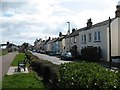
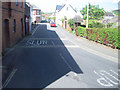
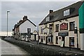
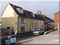
Starcross is a compact built-up area in England, spanning 40.8 hectares. Its small size means it is tightly woven, with a strong sense of local identity. The area’s median age of 70 suggests a community skewed towards older residents, though this does not preclude younger families. Living in Starcross offers proximity to essential services, with five nearby rail stations, including Starcross Railway Station and Lympstone Village Railway Station, ensuring easy access to regional transport networks. The area’s broadband score of 97 reflects excellent fixed-line connectivity, while mobile coverage of 80 is solid for most needs. For homebuyers, Starcross balances practicality with quiet charm, with amenities like Spar, M&S Exmouth, and Iceland Exmouth within reach. The presence of two Starcross Primary Schools underscores the area’s focus on education, though the mix of amenities and transport links makes it appealing for those prioritising convenience over sprawling urban sprawl.
- Area Type
- Built Up Area 250
- Area Size
- 40.8 hectares
- Population
- Not available
- Population Density
- Not available
Starcross offers a range of amenities within practical reach, including five retail options like Spar, M&S Exmouth, and Iceland Exmouth, providing everyday shopping convenience. The area’s five ferry landings, such as Turf Lock Inn Ferry Landing, suggest access to water-based transport and leisure activities. While parks or green spaces are not explicitly mentioned in the data, the presence of rail stations and ferry access implies a mix of urban and coastal elements. The compact nature of the area means residents can walk or cycle to most amenities, fostering a community-oriented lifestyle. The combination of retail, transport, and proximity to waterways contributes to a practical, if modest, quality of life for those prioritising accessibility over expansive recreational spaces.
Amenities
Schools
The nearest schools to Starcross include two instances of Starcross Primary School, both categorised as primary institutions. While the data does not provide Ofsted ratings or academic performance metrics, the presence of two primary schools suggests a focus on early education within the area. Families with young children may benefit from this proximity, though the lack of secondary schools or further education institutions means students may need to travel for higher education. The duplication of school names in the data may reflect administrative details rather than separate institutions, but the emphasis on primary education aligns with the area’s older demographic profile.
| Rank | School | Type | Entry gender | Ages |
|---|
Explore more schools in this area
Go to Schools tabDemographics
The population of Starcross has a median age of 70, indicating a community predominantly composed of older residents. This age profile shapes the area’s character, with household types and accommodation types reflecting long-term occupancy patterns. Home ownership is high, with 72% of properties owner-occupied, suggesting stability and a lack of transient populations. The data does not specify ethnic or religious diversity, but the absence of detailed breakdowns implies a homogenous demographic. For buyers, this means a neighbourhood with established residents and fewer rental properties, which can influence property values and community dynamics. The lack of specific deprivation data means it is unclear how economic factors impact daily life, though the high home ownership rate generally correlates with lower deprivation levels.
Household Size
Accommodation Type
Tenure
Ethnic Group
Religion
Household Composition
Age
Household Deprivation
NS-SEC
Explore more demographic insights in this area
Go to Demographics tabPlanning
Planning Constraints
- Crime RiskPremium