Area Overview for St Tudy
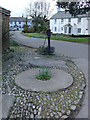
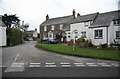
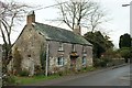
Photos of St Tudy


Area Information
St Tudy is a compact built-up area in England, covering 32.1 hectares. It is a small, established community where the median age of residents is 70, suggesting a population skewed towards older adults. The area is characterised by a strong sense of local identity, with a high rate of home ownership—74% of properties are owner-occupied. Daily life here is likely shaped by proximity to nearby amenities and a quieter, more settled environment. While the area’s size is modest, it offers a balance of residential living and practical access to essential services. St Tudy is not a sprawling urban centre but a focused, self-contained community where residents may prioritise stability and familiarity. The presence of two primary schools and nearby retail and transport hubs indicates a functional, if unassuming, infrastructure. For those seeking a low-maintenance lifestyle with a strong community feel, St Tudy provides a distinct alternative to busier urban settings.
- Area Type
- Built Up Area 250
- Area Size
- 32.1 hectares
- Population
- Not available
- Population Density
- Not available
The lifestyle in St Tudy is supported by a range of nearby amenities within practical reach. The area has five retail outlets, including Asda St, Spar, and Co-op Port, providing everyday shopping and convenience. Two metro stations—Boscarne Junction and Bodmin General—offer access to public transport, enabling residents to travel to nearby towns or cities. While the data does not mention parks or leisure facilities, the presence of retail and transport hubs suggests a functional, community-focused environment. The combination of local shops and public transport options enhances daily life, allowing residents to manage errands and travel without relying heavily on private vehicles. This accessibility contributes to a practical, low-stress lifestyle in a compact setting.
Amenities
Schools
St Tudy has two primary schools within its vicinity: St Tudy CofE VA Primary School and St Tudy CofE Primary School, both of which serve the local community. The second school holds an Ofsted rating of ‘good’, reflecting a satisfactory standard of education. The presence of two primary schools suggests that families with young children have access to multiple educational options, though no secondary schools are listed in the data. This focus on primary education may indicate that the area is well-suited for families with children under 11, but those requiring secondary schooling may need to look beyond St Tudy. The ‘good’ rating at one school provides reassurance for parents seeking a reliable foundation for their children’s early education.
| Rank | School | Type | Entry gender | Ages |
|---|
Explore more schools in this area
Go to Schools tabDemographics
The population of St Tudy has a median age of 70, the highest recorded age range in the data, indicating a community predominantly composed of older residents. This suggests a demographic profile where retirement and long-term residency are common. Home ownership in the area is robust, with 74% of properties owned by their occupants, reflecting a stable housing market. The data does not specify household composition or accommodation types, but the high home ownership rate implies a largely settled population with fewer rental properties. The area’s demographic makeup is not detailed in terms of ethnic diversity or religious composition, but the absence of specific figures suggests a homogeneous community. The age profile and ownership statistics together suggest a place where residents may have long-term ties to the area, with limited turnover of new arrivals.
Household Size
Accommodation Type
Tenure
Ethnic Group
Religion
Household Composition
Age
Household Deprivation
NS-SEC
Explore more demographic insights in this area
Go to Demographics tabPlanning
Planning Constraints
- Crime RiskPremium