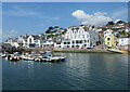
Area Overview for St Mawes
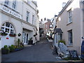
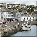
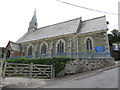
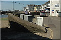
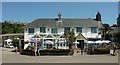
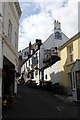
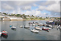
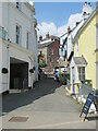
Photos of St Mawes


Area Information
St Mawes is a compact built-up area spanning 68.3 hectares, offering a quiet, low-density living environment in England. With a median age of 70, the community here is predominantly older, suggesting a demographic skewed toward retirees or long-term residents. The area’s charm lies in its accessibility to nearby amenities, including two primary schools, ferry services, and rail connections. Daily life in St Mawes is shaped by its proximity to Falmouth, with residents able to reach shops, transport hubs, and cultural attractions within practical distance. The low crime risk score of 81 indicates a safe neighbourhood, which is reassuring for families and individuals seeking stability. While the area’s population size is modest, its infrastructure supports a functional lifestyle, blending local character with regional connectivity. For those considering homes in St Mawes, the balance of tranquillity and access to essential services makes it an appealing option, particularly for those prioritising safety and a slower pace of life.
- Area Type
- Built Up Area 250
- Area Size
- 68.3 hectares
- Population
- Not available
- Population Density
- Not available
Living in St Mawes offers access to a range of amenities within practical reach. Retail options include Co-op St, Spar Bar, and Tesco Falmouth, providing everyday shopping convenience. The area’s ferry services, such as St Mawes Ferry Landing and Falmouth National Maritime Museum Ferry Landing, connect residents to nearby towns and attractions, enhancing both leisure and commuting possibilities. Rail stations at Falmouth Docks, Falmouth Town, and Penmere offer further regional links. For leisure, the proximity to Falmouth’s maritime heritage and cultural sites adds to the area’s appeal. While the data does not specify parks or recreational spaces, the mix of retail, transport, and ferry options suggests a lifestyle that balances local convenience with broader connectivity, supporting both practical needs and occasional outings.
Amenities
Schools
Residents of St Mawes have access to two primary schools: St Mawes Community Primary School and St Mawes Primary School. Both institutions serve the local community, providing education for younger children. The presence of two primary schools suggests a focus on early education, though no Ofsted ratings are provided in the data. For families, this means a choice of schools within the area, which can be beneficial for ensuring children attend a school close to home. However, the absence of secondary school options or detailed performance metrics means parents may need to look further afield for secondary education. The availability of primary schools supports the area’s appeal to families, though the broader educational landscape remains unexplored in the provided data.
| Rank | A + A* % | School | Type | Entry gender | Ages |
|---|---|---|---|---|---|
| 1 | N/A | St Mawes Community Primary School | primary | N/A | N/A |
| 2 | N/A | St Mawes Primary School | primary | N/A | N/A |
Explore more schools in this area
Go to Schools tabDemographics
The population of St Mawes has a median age of 70, reflecting a community where older residents form a significant proportion. Home ownership stands at 67%, indicating a mix of owner-occupied properties and rental units. The data does not specify household composition or accommodation types, but the high median age suggests a demographic focused on retirement or long-term residency. The area’s demographic profile implies a stable, low-turnover community, with limited data on diversity or cultural composition. For quality of life, the absence of detailed figures on deprivation or household types means broader implications remain unexplored. However, the safety score of 81/100 underscores a secure environment, which is likely to appeal to older residents seeking a peaceful, low-risk living situation.
Household Size
Accommodation Type
Tenure
Ethnic Group
Religion
Household Composition
Age
Household Deprivation
NS-SEC
Explore more demographic insights in this area
Go to Demographics tabPlanning
Planning Constraints
- Crime RiskLocked