Area Overview for St Ives (Cornwall)
Photos of St Ives (Cornwall)


Area Information
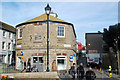
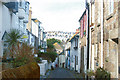
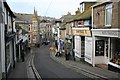
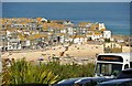
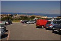
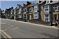
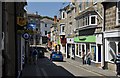
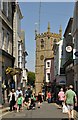
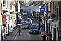
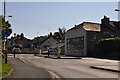
Living in St Ives (Cornwall) means residing within a compact built-up area covering just 1.6 km². This coastal town blends the heritage of a former fishing port with the modern identity of a major seaside resort. You will find yourself surrounded by colour-washed stone cottages and cobbled streets that cluster around the harbour. The area defines its character through a mix of sandy beaches like Porthmeor, historic landmarks such as St Ia's Church, and an artistic atmosphere established by its history as an art colony. The local community benefits from a mild climate and front-row access to the Celtic Sea. Originally a medieval fishing settlement, the town has fully transitioned into a leisure-focused destination. Today, the focus is on tourism supported by the distinctive harbour and vibrant tourism industry. You live in a space where winding roads and cliffside routes replace major motorways, making the environment inherently calm but well-connected via the A30 trunk road and A3074. This small urban footprint means your daily surroundings are immediately accessible. Whether you are visiting the Sloop Inn or exploring the old town along Fore Street, the scale of St Ives (Cornwall) keeps everything within easy reach. The transition from a prosperous pilchard-fishing hub to a holiday town is visible in every Victorian building and restored building that lines the shore. Residents enjoy a unique setting where history meets holiday appeal without the sprawl of larger cities.
- Area Type
- Built Up Area 250
- Area Size
- 1.6 km²
- Population
- Not available
- Population Density
- Not available
Living in St Ives (Cornwall) places you at the centre of a curated aesthetic and leisure experience. Your daily round of errands passes through areas stocked by notable retailers including the Co-op on St Street, Spar, and Co-op Royal. These shops provide essential goods and are clustered conveniently for residents. Beyond retail, the transport infrastructure itself becomes part of the lifestyle, with five rail stations within practical reach serving as gateways to the wider peninsula. The town offers a rich tapestry of leisure rooted in its maritime history. You can visit the harbour, explore the old town along Fore Street, or visit the Sloop Inn, a 14th-century establishment dating from c.1312. Porthmeor Beach serves as a focal point for recreation, particularly popular for surfing given the exposed coast. The area is defined by its artistic heritage, highlighted by landmarks like St Ia's Church built between 1410 and 1434 and the 1766–1770 rebuilt Smeaton's Pier. Safety assessments indicate a low crime risk with a score of 71 out of 100, contributing to a peaceful atmosphere. This safety record reinforces the appeal for those seeking a quiet life away from busy city centres. Whether you are walking the winding cobbled streets or watching golosers take shelter at the carnival sideshow, the amenities support a rhythm of life that blends history with coastal relaxation. The presence of multiple stations and shops ensures you never feel cut off, while the natural beauty keeps the town feeling distinctly separate from urban sprawl.
Amenities
Schools
Families considering St Ives (Cornwall) should note the presence of three main educational institutions within the immediate vicinity. St Ives Infant School operates under two distinct frames; one is a standard primary school, while the other functions as an academy. The academy version of St Ives Infant School holds an Ofsted rating of good, indicating a standard of education that meets high expectations for that setting. Another primary option nearby is St Ives Junior School, which currently holds an Ofsted rating of satisfactory. This school also serves a primary age group, working in conjunction with the infant schools to cover the early years of education. The concentration of primary schools reflects a specific demographic reality in St Ives (Cornwall), where a significant service for younger children exists alongside the broader population profile. There are no comprehensive data points available regarding secondary schools, special educational needs provision, or catchment areas extending beyond these specific primary institutions. For families with older children, you would need to look outside the immediate town boundary, as the provided data does not list comprehensive or secondary colleges. The existing primary facilities offer a mix of academy standards and traditional local education, providing options for early schooling within the town limits.
| Rank | School | Type | Entry gender | Ages |
|---|
Explore more schools in this area
Go to Schools tabDemographics
The community profile in St Ives (Cornwall) reflects the town's status as a longstanding resort. The median age stands at 70 years, indicating a population dominated by older residents. While specific age range breakdowns beyond the median are not detailed, this high median suggests a retirement-demographic bias common in popular holiday destinations. You are more likely to meet older neighbours than young families moving into the area for the first time. Home ownership is prevalent throughout St Ives (Cornwall), with 61% of the population owning their homes. This high rate of ownership points to a stable, established community where most residents have settled permanently over many years. The remaining 39% reside in rented accommodation, which aligns with the influx of tourists and second-home buyers seeking properties near the harbour and beaches. The area features a mix of permanent residents and those utilizing holiday homes, shaping a dynamic social rhythm. There is no data provided regarding specific breakdowns of household composition, accommodation types beyond the ownership split, ethnicity, or religious affiliation. Consequently, the picture presented relies on the clear statistic regarding home ownership and the overarching age profile. The dominance of older residents and high ownership rates defines the everyday social texture of the town, even if finer demographic details remain unrecorded in available reports.
Household Size
Accommodation Type
Tenure
Ethnic Group
Religion
Household Composition
Age
Household Deprivation
NS-SEC
Explore more demographic insights in this area
Go to Demographics tabPlanning
Planning Constraints
- Crime RiskPremium