Area Overview for St. George West Ward
Photos of St. George West Ward


Area Information
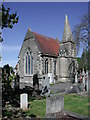
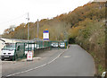
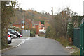
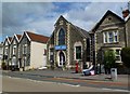
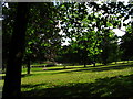
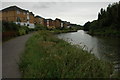
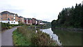
Living in St. George West Ward means residing in a compact district of just 1.1 km² located on the eastern edge of Bristol. This electoral ward encompasses specific neighbourhoods such as St George Park and Crofts End, stretching from Avonvale Road down to the River Avon. The area carries a deep historical weight, originating from the parish of St George which was consecrated in 1756 specifically for a local coal mining community. You will find yourself near St George Park, a 38-acre green space opened in 1894 on former Fire Engine Farm land. The history here is tangible; the Fire Engine Inn survives from the coal mining era opposite the park entrance. Daily life includes proximity to landmarks like the former poorhouse on Hudds Vale Road, now converted into apartments, and the historic clay pits that once defined the landscape. You might appreciate the quiet character of Plummers Hill or the Victorian housing found in Crofts End. The ward briefly functioned as an urban district between 1894 and 1898 before merging into the broader city structure in 1898. Currently, the area features a mix of residential zones, including parts of Redfield in the south-west. Transport links connect you to the wider Bristol region, making this a practical choice for those who value history alongside convenience. The combination of statutory waste areas and open green spaces creates a distinct living environment within the South West county.
- Area Type
- District Borough Unitary Ward
- Area Size
- 1.1 km²
- Population
- Not available
- Population Density
- Not available
Demographics
The community profile in St. George West Ward reflects a settled population with a median age of 70. This figure indicates a demographic skewed heavily toward older residents, suggesting a neighbourhood accustomed to slower-paced living. Home ownership stands at 56% across the ward, meaning just over half of the households own their homes outright or with a mortgage. The remaining 44% of households rely on renting, which is common in areas with established housing stock. Accommodation types vary, though exact breakdowns per source名录 are not detailed in the current dataset. You will encounter a population that has lived here for generations, often linked to the area's industrial past. The households in St. George West Ward are drawn primarily from specific age brackets aligned with the median figure of 70. This age structure influences local demand, pushing services toward healthcare and leisure suitable for seniors rather than families with young children. Diversity in the ward currently follows general patterns for the region, but specific ethnic and religious statistics are not provided in the available information. The high home ownership rate suggests financial stability among long-term residents. As you consider buying a home here, note that the area hosts a significant proportion of owners rather than tenants. The social fabric remains stable, driven by an elderly cohort who have soured the local culture over decades.
Household Size
Accommodation Type
Tenure
Ethnic Group
Religion
Household Composition
Age
Household Deprivation
NS-SEC
Explore more demographic insights in this area
Go to Demographics tabPlanning
Planning Constraints
- Flood RiskPremium
- Ramsar Wetland SitesPremium
- Area of Outstanding Natural BeautyPremium
- Protected Nature ReservePremium
- Protected WoodlandPremium