Area Overview for SN3 4NH
Photos of SN3 4NH
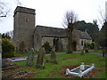

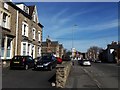
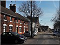


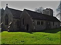

64 photos from this area
Area Information
Key information about the SN3 4NH including its size, population, and administrative classification.
- Area Type
- Postcode
- Area Size
- 1.1 hectares
- Population
- 1516
- Population Density
- 5206 people/km²
House Prices in SN3 4NH
34
Properties
£194,160
Average Sold Price
£53,000
Lowest Price
£290,000
Highest Price
Showing 34 properties
| Address | Type | Beds | Baths | Last Sale Price | Last Sale Date | |
|---|---|---|---|---|---|---|
| 147 Ermin Street, Stratton St Margaret, Swindon, SN3 4NH | Detached | 3 | 2 | £285,000 | Dec 2025 | |
| 137 Ermin Street, Stratton St Margaret, Swindon, SN3 4NH | Terraced | 3 | 1 | £180,000 | Jan 2025 | |
| 135 Ermin Street, Stratton St Margaret, Swindon, SN3 4NH | Terraced | 3 | 1 | £227,000 | Oct 2023 | |
| 155 Ermin Street, Stratton St Margaret, Swindon, SN3 4NH | Detached | 2 | 1 | £260,000 | Oct 2021 | |
| Rossmere, 121 Ermin Street, Stratton St Margaret, Swindon, SN3 4NH | house | - | - | £270,000 | Jun 2021 | |
| 139 Ermin Street, Stratton St Margaret, Swindon, SN3 4NH | house | - | - | £177,000 | Feb 2021 | |
| 161 Ermin Street, Stratton St Margaret, Swindon, SN3 4NH | Terraced | 3 | 1 | £205,000 | Mar 2020 | |
| 119 Ermin Street, Stratton St Margaret, Swindon, SN3 4NH | house | - | - | £228,000 | Jan 2020 | |
| 157 Ermin Street, Stratton St Margaret, Swindon, SN3 4NH | Semi-detached | 2 | 1 | £136,500 | Nov 2019 | |
| 141 Ermin Street, Stratton St Margaret, Swindon, SN3 4NH | house | 4 | - | £230,000 | Mar 2019 |
Page 1 of 4
Energy Efficiency in SN3 4NH
Amenities
Schools
| Rank | School | Type | Entry gender | Ages |
|---|
Explore more schools in this area
Go to Schools tabDemographics
Household Size
Two person
most common
Accommodation Type
Houses
most common
Tenure
79
majority
Ethnic Group
White
most common
Religion
N/A
most common
Household Composition
N/A
most common
Age
47
median
Adults (30-64 years)
most common
Household Deprivation
N/A
with no deprivation
NS-SEC
37
in Lower managerial occupations
Explore more demographic insights in this area
Go to Demographics tabPlanning
Planning Constraints
- Flood RiskPremium
- Ramsar Wetland SitesPremium
- Area of Outstanding Natural BeautyPremium
- Protected Nature ReservePremium
- Protected WoodlandPremium