Area Overview for PL30 5LB
Photos of PL30 5LB


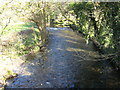


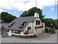
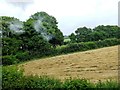
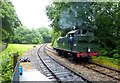


54 photos from this area
Area Information
Key information about the PL30 5LB including its size, population, and administrative classification.
- Area Type
- Postcode
- Area Size
- 75.4 hectares
- Population
- 1360
- Population Density
- 46 people/km²
House Prices in PL30 5LB
38
Properties
£310,546
Average Sold Price
£100,000
Lowest Price
£660,000
Highest Price
Showing 38 properties
| Address | Type | Beds | Baths | Last Sale Price | Last Sale Date | |
|---|---|---|---|---|---|---|
| 2, Post Office Cottages, Chapel Road, Nanstallon, Bodmin, PL30 5LB | house | - | - | £182,500 | Jun 2021 | |
| Tregarthen House, Road From Stony Lane To Marshall Road, Nanstallon, Bodmin, PL30 5LB | house | 6 | 4 | £660,000 | Jun 2021 | |
| Boscarne Farm, Access To Boscarne, Nanstallon, Bodmin, PL30 5LB | Semi-detached | 4 | 1 | £310,000 | Feb 2019 | |
| Gwel Teg, Marshall Road, Nanstallon, Bodmin, PL30 5LB | Detached | 4 | 1 | £385,000 | Aug 2018 | |
| Brackenside, Marshall Road, Nanstallon, Bodmin, PL30 5LB | Bungalow | 3 | - | £249,950 | Feb 2017 | |
| Tremar, Institute Lane, Nanstallon, Bodmin, PL30 5LB | Bungalow | 3 | - | £304,000 | Mar 2016 | |
| Boscarne Mill, Access To Boscarne, Nanstallon, Bodmin, PL30 5LB | Detached | 5 | 3 | £412,000 | Dec 2015 | |
| 1, Post Office Cottages, Chapel Road, Nanstallon, Bodmin, PL30 5LB | house | - | - | £100,000 | Sep 2011 | |
| Lytherva, Chapel Road, Nanstallon, Bodmin, PL30 5LB | house | 3 | - | £275,010 | Dec 2005 | |
| The Gables, Chapel Road, Nanstallon, Bodmin, PL30 5LB | Bungalow | 3 | 1 | £227,000 | Oct 2004 |
Page 1 of 4
Energy Efficiency in PL30 5LB
Amenities
Schools
| Rank | School | Type | Entry gender | Ages |
|---|
Explore more schools in this area
Go to Schools tabDemographics
Household Size
Two person
most common
Accommodation Type
Houses
most common
Tenure
82
majority
Ethnic Group
White
most common
Religion
N/A
most common
Household Composition
N/A
most common
Age
47
median
Adults (30-64 years)
most common
Household Deprivation
N/A
with no deprivation
NS-SEC
30
in Lower managerial occupations
Explore more demographic insights in this area
Go to Demographics tabPlanning
Planning Constraints
- Flood RiskPremium
- Ramsar Wetland SitesPremium
- Area of Outstanding Natural BeautyPremium
- Protected Nature ReservePremium
- Protected WoodlandPremium