Area Overview for PL28 8RP
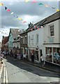
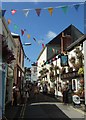
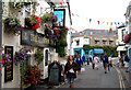
Photos of PL28 8RP

Area Information
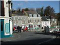
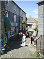
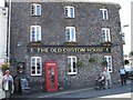
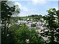
Living in PL28 8RP means residing within a compact residential cluster covering 27.1 hectares. This postcode contains a population of 1,005 residents, creating a neighbourhood with a population density of 886 people per square kilometre. You will find yourself in a setting defined by its small scale and specific location in England. The area functions as a tight-knit community where each household contributes to the local character. Daily life here revolves around proximity to the surrounding landscape and nearby services. Residents benefit from a controlled environment where movement through the streets is manageable. The distinct size of the area means that noise and activity from traffic are naturally contained. You gain access to a stable community where neighbours often know one another by name. The postcode serves as a marker for a specific, manageable slice of regional life. Homebuyers here seek the quietude that comes with limited development pressure. Your daily commute likely involves short distances to local amenities and key hubs. The overall atmosphere remains consistent with a residential focus rather than commercial intensity.
- Area Type
- Postcode
- Area Size
- 27.1 hectares
- Population
- 1005
- Population Density
- 886 people/km²
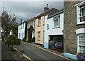
The property market in PL28 8RP centres on houses as the primary accommodation type. With home ownership at 51%, you will find a neighbourhood largely composed of residents who have purchased their homes. This balance suggests a mature market where established homes dominate the stock. Buyers looking at this specific postcode should expect to focus on detached or semi-detached houses. The high concentration of house tenure indicates fewer purpose-built rental developments exist here. Your search will likely yield traditional properties rather than modern apartment blocks. The modest total population of 1,005 limits the inventory available within the immediate boundaries. You may need to expand your search to nearby streets to find sufficient variety. The 51% ownership rate implies that saleable stock is limited to private exchanges. Buyers seeking flats or bungalows may find few options inside this specific cluster. The market reflects a typical residential village dynamic where ownership transfers happen slowly.
House Prices in PL28 8RP
Showing 1 properties
| Address | Type | Beds | Baths | Last Sale Price | Last Sale Date | |
|---|---|---|---|---|---|---|
| Owners Accommodation, Prideaux Place, Tregirls Lane, Padstow, PL28 8RP | Flat | - | - | - | - |
Energy Efficiency in PL28 8RP
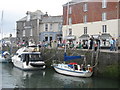
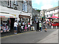
Your lifestyle in PL28 8RP is defined by convenient access to retail and ferry services just steps away. Two major supermarkets, Tesco Padstow and Spar, provide essential groceries and household items within easy reach. You can visit additional Spar outlets for specific dietary needs or impulse buys without travelling far. Two ferry landings, Padstow Ferry Landing and Rock Padstow Ferry Landing, link you to speedboat and sailboat transport options. This access allows you to enjoy leisure trips to nearby coastal areas quickly. The nearby amenities create a practical daily routine where errands take only minutes to complete. You do not need a long commute to shop for your weekly necessities. The presence of these transport hubs adds a unique layer of leisure potential to your weekly schedule. Families can organise boat trips or enjoy views of vessels in the nearby water. Retail variety includes both generic chains and local brands suitable for a small neighbourhood.
Amenities
Schools
| Rank | School | Type | Entry gender | Ages |
|---|
Explore more schools in this area
Go to Schools tabDemographics
The community in PL28 8RP is characterised by a median age of 47 years. Most commonly found residents fall within the adult age range of 30 to 64 years. You are entering a neighbourhood where the demographic skew is towards mature households. House ownership stands at 51%, indicating a near-even split between owners and renters. The predominant accommodation type consists of houses, which shapes the street aesthetics and garden spaces. You will encounter a population where white ethnicity forms the predominant group. This age profile suggests families with older children or empty nesters form a significant portion of the tenure. The house ownership rate of just over half means many residents have settled roots in the property. The prevalence of houses over flats influences the social fabric and noise levels in the streets. Local life revolves around garden networks and street interactions typical of this housing style. The age distribution reflects a stable community rather than a transient student or young professional hub.
Household Size
Accommodation Type
Tenure
Ethnic Group
Religion
Household Composition
Age
Household Deprivation
NS-SEC
Explore more demographic insights in this area
Go to Demographics tabPlanning
Planning Constraints
- Flood RiskPremium
- Ramsar Wetland SitesPremium
- Area of Outstanding Natural BeautyPremium
- Protected Nature ReservePremium
- Protected WoodlandPremium