Area Overview for PL20 7UY
Photos of PL20 7UY
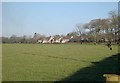
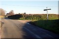
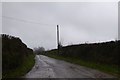
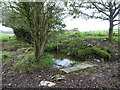
7 photos from this area
Area Information
Key information about the PL20 7UY including its size, population, and administrative classification.
- Area Type
- Postcode
- Area Size
- 23.6 hectares
- Population
- 1613
- Population Density
- 121 people/km²
House Prices in PL20 7UY
33
Properties
£289,438
Average Sold Price
£117,000
Lowest Price
£535,000
Highest Price
Showing 33 properties
| Address | Type | Beds | Baths | Last Sale Price | Last Sale Date | |
|---|---|---|---|---|---|---|
| 19 Morley Drive, Crapstone, PL20 7UY | house | 4 | 2 | £433,000 | Jul 2025 | |
| 30 Morley Drive, Crapstone, PL20 7UY | house | - | - | £530,000 | Jun 2023 | |
| 25 Morley Drive, Crapstone, PL20 7UY | house | - | - | £415,000 | Apr 2023 | |
| 14 Morley Drive, Crapstone, PL20 7UY | house | - | - | £506,000 | Jun 2021 | |
| 31 Morley Drive, Crapstone, PL20 7UY | house | - | - | £395,000 | Feb 2021 | |
| 6 Morley Drive, Crapstone, PL20 7UY | Detached | 4 | 3 | £345,000 | Nov 2020 | |
| 34 Morley Drive, Crapstone, PL20 7UY | house | 4 | - | £535,000 | Aug 2020 | |
| 5 Morley Drive, Crapstone, PL20 7UY | Detached | - | - | £310,000 | Nov 2019 | |
| 15 Morley Drive, Crapstone, PL20 7UY | Detached | 4 | 2 | £370,000 | May 2019 | |
| 28 Morley Drive, Crapstone, PL20 7UY | Detached | 4 | 2 | £345,000 | Dec 2018 |
Page 1 of 4
Energy Efficiency in PL20 7UY
Amenities
Schools
| Rank | School | Type | Entry gender | Ages |
|---|
Explore more schools in this area
Go to Schools tabDemographics
Household Size
Two person
most common
Accommodation Type
Houses
most common
Tenure
66
majority
Ethnic Group
White
most common
Religion
N/A
most common
Household Composition
N/A
most common
Age
47
median
Adults (30-64 years)
most common
Household Deprivation
N/A
with no deprivation
NS-SEC
41
in Lower managerial occupations
Explore more demographic insights in this area
Go to Demographics tabPlanning
Planning Constraints
- Flood RiskPremium
- Ramsar Wetland SitesPremium
- Area of Outstanding Natural BeautyPremium
- Protected Nature ReservePremium
- Protected WoodlandPremium