Area Overview for PL19 0PE
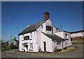
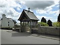
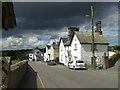
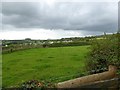
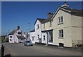
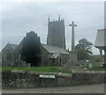
Photos of PL19 0PE


Area Information
PL19 0PE represents a small residential cluster in Devon, England. This specific postcode covers 6650 square metres and is home to a population of 1718 people. You will find a clear sense of calm within this postcode, characterised by low-density living. The area operates at a population density of just 24 people per square kilometre, indicating spacious surroundings rather than urban congestion. For those seeking homes in PL19 0PE, the environment offers isolation without complete isolation. The location is defined by its modest footprint, creating a community where neighbours are likely to know one another. This scale suits individuals or families who prioritise quiet over proximity to immediate city centres. Living in PL19 0PE means enjoying a defined neighbourhood where the built environment is compact. The small area size contributes to a sheltered feel, making it distinct from larger, sprawling towns nearby. It is a place where the physical boundaries are clear and the residential character remains consistent throughout the postcode. You can expect a setting that values stability and a slower pace of life over rapid development.
- Area Type
- Postcode
- Area Size
- 6650 m²
- Population
- 1718
- Population Density
- 24 people/km²
The housing stock in PL19 0PE is defined by a dominant owner-occupied market. Houses make up the primary form of accommodation within this postcode area. Exactly 73% of households own their properties outright. This statistic shapes the character of housing transactions, as most homes are sold from existing owners rather than landlords. For buyers searching for homes in PL19 0PE, the market is largely traditional with established dwellings. The prevalence of houses aligns with the area's low population density and small 6650 square metre footprint. There is little evidence of tower blocks or shared-ownership schemes in the immediate vicinity you are viewing. This market structure implies that property values are driven by owner investment and maintenance rather than rental yields. The accommodation type data confirms that you will encounter single-family or detached dwellings. Such a market reduces the unpredictability often found in high-rental-activity zones. When assessing this area, you are looking at a stable sector where long-term residents constitute the vast majority of sellers.
House Prices in PL19 0PE
Showing 6 properties
| Address | Type | Beds | Baths | Last Sale Price | Last Sale Date | |
|---|---|---|---|---|---|---|
| 2, Edgcumbe Terrace, Higher Edgcumbe Lane, Milton Abbot, PL19 0PE | Terraced | 4 | 1 | £230,000 | May 2022 | |
| 3, Edgcumbe Terrace, Higher Edgcumbe Lane, Milton Abbot, PL19 0PE | Terraced | 2 | 1 | £145,000 | May 2014 | |
| 4, Edgcumbe Terrace, Higher Edgcumbe Lane, Milton Abbot, PL19 0PE | Cottage | 3 | 2 | £151,500 | Apr 2011 | |
| 1B, Edgcumbe Terrace, Higher Edgcumbe Lane, Milton Abbot, PL19 0PE | Detached | - | - | £115,000 | Nov 2010 | |
| 1, Edgcumbe Terrace, Higher Edgcumbe Lane, Milton Abbot, PL19 0PE | Terraced | 2 | 1 | - | - | |
| 5, Edgcumbe Terrace, Higher Edgcumbe Lane, Milton Abbot, PL19 0PE | Semi-detached | - | - | - | - |
Energy Efficiency in PL19 0PE
Daily life in PL19 0PE revolves around nearby amenities that are within practical reach of residents. You have access to five notable retail locations across the wider area. Specific venues like Tesco Launceston, Lidl Launceston, and M&S Launceston serve the shopping needs of the community. These supermarkets provide essential groceries and household goods without requiring a car for the most basic tasks. Mobility does not need to be perfect if you prefer supported transport. A railway station nearby offers a rail link, with Gunnislake Railway Station being the key transport hub. This single rail option connects the postcode area to broader transport networks. The proximity of major retailers and a train station creates a functional lifestyle despite the rural setting. Residents can enjoy the quiet of a small cluster while still accessing commercial services quickly. The blend of essential high-street names with a local rail halt supports an independent living style.
Amenities
Schools
Families considering schools near PL19 0PE have access to several primary institutions in close proximity. Milton Abbot School operates as a primary establishment serving the local cluster. You will also find Lew Trenchard Church of England Primary School nearby. This school holds a 'good' Ofsted rating, providing a measurable benchmark for educational quality. Milton Abbot Primary School is another option listed for primary education within reach. These facilities form a network that supports the age profile of the local population. The concentration of primary schools suggests a dedicated focus on younger children rather than secondary education centres. When evaluating education for children living in PL19 0PE, the immediate choices are limited to primary education venues. This mix means parents rely heavily on local peers before considering intake areas further away. The presence of a 'good' rated school like Lew Trenchard offers a point of confidence for those prioritising academic standards.
| Rank | School | Type | Entry gender | Ages |
|---|
Explore more schools in this area
Go to Schools tabDemographics
The people living in PL19 0PE reflect a mature community profile. The median age stands at 47, placing the demographic firmly in the middle to older adult bracket. Most common age groups are adults between 30 and 64 years, suggesting a family-friendly environment alongside households in later life. You will note that 73% of residents own their homes outright. This high ownership rate indicates financial stability and long-term roots within the area rather than a transient rental population. The population consists predominantly of White residents, contributing to a homogenous community feel. Accommodation types are primarily houses, confirming a suburban or rural residential setting rather than high-density blocks. With 24 people per square kilometre, the area does not suffer from overcrowding. This demographic shape supports local services tailored to families and older citizens. The strong home ownership figure of over three-quarters suggests that locals view PL19 0PE as a permanent home base. You can rely on a neighbourhood maintained by people who have settled down.
Household Size
Accommodation Type
Tenure
Ethnic Group
Religion
Household Composition
Age
Household Deprivation
NS-SEC
Explore more demographic insights in this area
Go to Demographics tabPlanning
Planning Constraints
- Flood RiskPremium
- Ramsar Wetland SitesPremium
- Area of Outstanding Natural BeautyPremium
- Protected Nature ReservePremium
- Protected WoodlandPremium