Area Overview for PL17 7TR
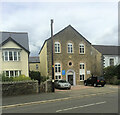
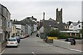
Photos of PL17 7TR


Area Information
PL17 7TR defines a specific residential cluster within Cornwall, covering a modest footprint of 1,196 square metres and housing a population of 2,258 people. This postcode represents a compact community where daily life revolves around close proximity to neighbours and established local services. You are living in an area where density remains manageable at 1,293 people per square kilometre, ensuring a quiet environment without the overwhelming scale of larger urban developments. The location offers a distinct advantage for those seeking stability, as the resident base is predominantly established homeowners rather than transient tenants. Living in PL17 7TR means accessing a functional neighbourhood with direct transport links and essential retail options just within practical reach. The area does not suffer from major planning constraints such as flood risks or protected nature reserves, which simplifies future developments and ensures a stable built environment. You can expect a straightforward living experience where the boundaries between private gardens and public spaces are clear and defined. The community feels grounded and practical, with a population structure that supports long-term settlement. There are no hidden environmental hazards to navigate, and the lack of AONB or Ramsar site coverage removes potential hurdles for residents looking at planning permissions or future property improvements. This makes PL17 7TR a straightforward choice for anyone prioritizing safety and clarity in their home search.
- Area Type
- Postcode
- Area Size
- 1196 m²
- Population
- 2258
- Population Density
- 1293 people/km²
The property market in PL17 7TR is characterised by a heavy lean towards ownership. Since 78 per cent of residents own their homes, you are looking at an area where sales are likely driven by exchanges between existing owners rather than high volumes of new-build launches or private rentals. This figure suggests a slower, more deliberate market where property values may reflect long-term local knowledge rather than speculative investment trends. The predominant accommodation type is houses, meaning you will find single-family structures rather than flats or apartments. This stock typically appeals to buyers seeking privacy and space, fitting the rural profile of the Cornwall coastline. Homes in PL17 7TR cater to individuals and families who have already entered the property ladder, as indicated by the low proportion of renters. This structure often implies that the local stock consists of established properties rather than modern developments. When viewing homes in this postcode, expect brick-built properties or stone houses typical of the local architecture. The small area size of just over 1,000 square metres further constrains the market, limiting inventory and making each potential sale event significant for the local community dynamics. Buyers should be prepared for a competitive but stable environment where demand may be driven by lifestyle preferences for the Cornish coast rather than purely economic factors. The lack of tenanted stock means fewer看上at-flats options and a focus on traditional garden houses.
House Prices in PL17 7TR
Showing 3 properties
| Address | Type | Beds | Baths | Last Sale Price | Last Sale Date | |
|---|---|---|---|---|---|---|
| 2 Pentillie Gardens, Callington, PL17 7TR | Detached | - | - | £272,781 | Sep 2003 | |
| 3 Pentillie Gardens, Callington, PL17 7TR | Detached | - | - | - | - | |
| 1 Pentillie Gardens, Callington, PL17 7TR | Detached | - | - | - | - |
Energy Efficiency in PL17 7TR
Living in PL17 7TR offers convenient access to essential amenities without the need for driving into larger towns for daily needs. You will find five retail options within practical reach, including Spar, Tesco Callington, and Asda Gunnislake. These supermarkets provide everything from daily groceries to household essentials, ensuring you do not have to travel far for shopping. Local life is also supported by robust rail connections, with Gunnislake Railway Station, Calstock Railway Station, and Bere Alston Railway Station nearby. These stations serve as gateways for occasional trips outside the immediate area or for attending events in surrounding locations. The neighbourhood is designed for practical living rather than entertainment-focused leisure. While the data highlights retail and transport, the absence of mentioned parks or leisure centres suggests a lifestyle centred around local convenience and quiet surroundings. Residents often supplement local retail with trips to larger centres like Callington or Gunnislake for specialised goods or dining experiences. This arrangement works well for those who prefer a self-sufficient home base with reliable transport links for when they need more variety. The presence of multiple railway stations indicates that the area is considered a transit point, blending rural living with accessible regional travel. You can manage your weekly shop easily from home, knowing local supermarkets are close by, while still having rapid rail access when plans change.
Amenities
Schools
| Rank | School | Type | Entry gender | Ages |
|---|
Explore more schools in this area
Go to Schools tabDemographics
The community in PL17 7TR is defined by an older demographic profile, with a median age of 47 years. Most residents fall within the 30 to 64 years age range, indicating a household composition built around working-age adults and families. This age distribution suggests a neighbourhood where residents have likely settled permanently rather than viewing the address as a stepping stone for young people just entering the market. Home ownership stands at 78 per cent, which is a significant majority for this postcode. This statistic confirms that the area is primarily an owner-occupied zone rather than a rental market. You will encounter a community where the majority of people have invested in their own properties, often creating roots that last for decades. The predominant ethnic group within PL17 7TR is White, reflecting a traditional demographic makeup common in rural and semi-rural parts of Cornwall. The dominance of houses as the primary accommodation type aligns with the high ownership figure, as opposed to high-density flats or apartments. Deprivation metrics are not prominently featured in the raw data compared to safety scores, but the high ownership rate often correlates with financial stability and lower household turnover. This creates a stable social fabric where neighbours know one another and the area maintains a consistent character over time. There is a strong sense of permanence in this community, driven by the fact that nearly four out of every five households belong to people who live there.
Household Size
Accommodation Type
Tenure
Ethnic Group
Religion
Household Composition
Age
Household Deprivation
NS-SEC
Explore more demographic insights in this area
Go to Demographics tabPlanning
Planning Constraints
- Flood RiskPremium
- Ramsar Wetland SitesPremium
- Area of Outstanding Natural BeautyPremium
- Protected Nature ReservePremium
- Protected WoodlandPremium