Area Overview for PL13 2LF
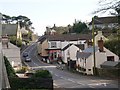
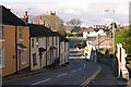
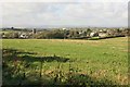
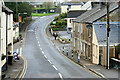
Photos of PL13 2LF


Area Information
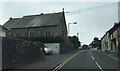
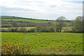
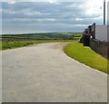
PL13 2LF represents a specific residential cluster within Cornwall, covering exactly 1.2 hectares and home to 1,841 people. This compact area offers living in PL13 2LF for those who prefer a neighbourhood defined by low density rather than high-rise or urban sprawl. With a population density of just 59 people per kilometre squared, daily life here unfolds at a measured pace. The postcode serves as a distinct address within a larger local context, yet it maintains its own identity as a small, contained community. Residents do not navigate through the congestion typical of larger towns but instead move through a space designed for quiet habitation. The physical footprint of this area is modest, meaning that distances between homes are typically short. This layout suits individuals seeking a straightforward arrangement where the immediate surroundings are easily accessible without the need for extensive travel. Whether you are considering homes in PL13 2LF or simply passing through, the scale of this postcode is manageable and clear. You can expect an environment where the layout is intuitive and the sense of place is grounded in its small size.
- Area Type
- Postcode
- Area Size
- 1.2 hectares
- Population
- 1841
- Population Density
- 59 people/km²
Homes in PL13 2LF cater primarily to those seeking ownership rather than renting. The market is characterised by a high prevalence of private residence, with 72% of the area showing home ownership status. This statistic indicates a property landscape where long-term occupancy is the norm, rather than a fluctuating rental market driven by university students or short-termholiday lets. The accommodation type data confirms that the area consists of houses, which aligns with the requirements of the older demographic found here. You are unlikely to find flats or purpose-built apartments when looking at properties in this specific postcode. Instead, the housing stock likely comprises standalone homes or semi-detached periods typical of the Cornish residential market. For a buyer, this environment offers the sound of a localised market where properties change hands less frequently than in tourist hotspots. The prevalence of owner-occupied homes suggests that pricing may reflect neighbourhood stability and established value rather than speculative investment potential. If you are house hunting, expect to engage with sellers who have lived in their properties for many years, offering a seamless transition into an existing community rather than moving into a newly constructed development.
House Prices in PL13 2LF
Showing 5 properties
| Address | Type | Beds | Baths | Last Sale Price | Last Sale Date | |
|---|---|---|---|---|---|---|
| Gwelmena, Road From Little Hendra To Shute Hill, Pelynt, PL13 2LF | Bungalow | 3 | - | £286,000 | Sep 2019 | |
| Trelane, Road From Little Hendra To Shute Hill, Pelynt, PL13 2LF | Bungalow | 2 | - | £150,000 | Jan 2012 | |
| Shir-dean, Road From Little Hendra To Shute Hill, Pelynt, PL13 2LF | Detached | 4 | 2 | - | - | |
| Westmor, Road From Little Hendra To Shute Hill, Pelynt, PL13 2LF | Bungalow | - | - | - | - | |
| Herons Nest, Road From Little Hendra To Shute Hill, Pelynt, PL13 2LF | house | - | - | - | - |
Energy Efficiency in PL13 2LF
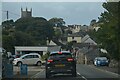
Daily life in PL13 2LF is supported by a practical range of amenities within easy reach. Retail needs are met by five local shops, including named provisions such as Spar, Spar, and Co-op East. These venues provide essential groceries and convenience items without requiring a trip to a distant town centre. Transport links include five railway stations in the immediate vicinity, specifically Sandplace Railway Station, Looe Railway Station, and Causeland Railway Station. These stations connect residents to wider travel networks, allowing easy access to other parts of Cornwall and beyond. Additionally, the area is served by five ferry locations, including Bodinnick Ferry Landing, Fowey Custom House Quay Ferry Landing, and Fowey Town Quay Ferry Landing. These crossings facilitate both passenger transport and vehicle access, enhancing the mobility of those living in this postcode. The presence of multiple transport hubs ensures that residents are not isolated despite the rural setting. Living in PL13 2LF means having immediate access to essential shopping and robust public transport options. You can manage daily errands locally while retaining the flexibility to travel further when necessary.
Amenities
Schools
Families considering schools near PL13 2LF have access to specific educational institutions within the local catchment. Pelynt School serves as a primary education provider in the vicinity, offering education for younger children within the community. Nearby, Pelynt Primary Academy also operates as a primary school and holds a 'good' Ofsted rating. This designation confirms that the facility meets the required standards set by educational regulators for child development and curriculum delivery. The presence of these two primary institutions ensures that young children can receive their early education without needing to travel long distances to larger towns. The mix of primary schools in the area suggests that the demographic, while predominantly elderly, still supports families with school-aged children. Parents do not need to look beyond these local options for primary-level education. These schools are part of the wider education network in the Looe area, providing a structured environment for learning. The availability of these specific facilities means that residential choices in PL13 2LF can be made with confidence regarding the immediate educational options for a child.
| Rank | School | Type | Entry gender | Ages |
|---|
Explore more schools in this area
Go to Schools tabDemographics
The community residing in PL13 2LF is defined by a mature population structure. The median age stands at 47 years, indicating that the area appeals to older generations rather than young professionals or families with small children. The most common age group consists of elderly residents aged 65 years and over, which shapes the social fabric of the neighbourhood. This demographic profile explains the high level of home ownership, as 72% of properties in PL13 2LF are owned outright or with a significant portion of the value already paid. The area predominantly consists of houses, reflecting the long-term commitment residents have made to establishing roots here. Demographic data shows the population is predominantly White, matching the broader regional statistics for Cornwall. There is little transient population turnover because the housing stock consists mostly of permanent family homes rather than rental properties. This stability means that neighbours have known each other for decades. Living in this area means engaging with a community where generations have remained in place, and the social networks are well established. You will find a resident base that values permanence, evidenced by the high rate of home ownership compared to new-build estates.
Household Size
Accommodation Type
Tenure
Ethnic Group
Religion
Household Composition
Age
Household Deprivation
NS-SEC
Explore more demographic insights in this area
Go to Demographics tabPlanning
Planning Constraints
- Flood RiskPremium
- Ramsar Wetland SitesPremium
- Area of Outstanding Natural BeautyPremium
- Protected Nature ReservePremium
- Protected WoodlandPremium