Area Overview for PL13 2BH
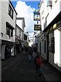
Photos of PL13 2BH


Area Information
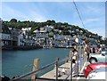
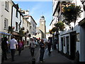
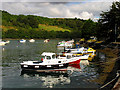
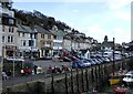
Living in PL13 2BH offers a snapshot of coastal life in a low-density residential cluster. This specific postcode covers a small area of just 447 square metres, yet it supports a community of 2,276 people. The result is a tight-knit neighbourhood where residents share close proximity to one another within a compact footprint. You are looking at a post-and-rise community that feels distinct from the sprawling suburbs found elsewhere in the region. Daily life here revolves around a mix of quiet residential streets and accessible local services that sit just outside your immediate garden gates. The area is defined by its intimacy rather than grand spaces, making it ideal for those who value convenience over room to expand. When you consider homes in PL13 2BH, you are entering a space where the built environment is efficient and the social fabric is woven closely together. This unique layout means you never need to travel far for your daily needs, reinforcing a lifestyle that is both functional and community-focused.
- Area Type
- Postcode
- Area Size
- 447 m²
- Population
- 2276
- Population Density
- 2153 people/km²
The property market in PL13 2BH is characterised almost entirely by owner-occupation. With 77% of residents owning their homes, this is not a rental-driven market but a stable zone of established tenure. The local housing stock consists predominantly of houses, aligning perfectly with the preference of the adult population for family or permanent single homesteads. This scarcity of rental properties means that homes in PL13 2BH are negotiated between private individuals rather than property management companies renting to short-term tenants. You are looking at a market where sellers are permanent homeowners who know their neighbourhood intimately. The low population density of just 2,153 people per square kilometre explains the preponderance of detached or semi-detached homes over terraced properties or flats. For buyers looking for a straightforward purchase, the ownership landscape is straightforward: most homes are sold via traditional means, not built for the private homeowner to collect a rental income.
House Prices in PL13 2BH
Showing 2 properties
| Address | Type | Beds | Baths | Last Sale Price | Last Sale Date | |
|---|---|---|---|---|---|---|
| Seawind, Chapel Ground, West Looe, PL13 2BH | Terraced | 3 | 2 | £595,000 | Jun 2021 | |
| Wind Harps, Chapel Ground, West Looe, PL13 2BH | Flat | 2 | 1 | - | - |
Energy Efficiency in PL13 2BH
Daily life in PL13 2BH is supported by a cluster of amenities that are within practical reach of your doorstep. Residents have access to five retail locations, including notable outlets like Cooper Looe, Co-op East, and Spar. These high street staples ensure you do not need to travel far for groceries or daily essentials. Transport links are equally convenient, with five railway options nearby including Looe Railway Station, Sandplace Railway Station, and Causeland Railway Station. These stations provide the primary method for commuters to access wider regional networks and connect with north-bound travel. Living in this area grants you easy access to both your first-stop shop and your train station without a long drive. You can grab a loaf of bread on the way to the platform or stop for coffee before heading to work. The concentration of these services within a small footprint makes PL13 2BH a exceptionally convenient place to call home.
Amenities
Schools
| Rank | School | Type | Entry gender | Ages |
|---|
Explore more schools in this area
Go to Schools tabDemographics
The population in PL13 2BH skews significantly towards middle adulthood, with a median age of 47 years. Adults between 30 and 64 years represent the most common age range, defining the core demographic of the neighbourhood. This age profile suggests a community of established residents rather than young families or single-person households in their twenties. Seventy-seven per cent of residents own their homes, indicating a deeply settled population that has invested in the local area for the long term. The predominant ethnic group is White, reflecting a historically stable social composition typical of this coastal zone. Houses dominate the accommodation type data, meaning you will not find the high-rise blocks or converted apartments common in city centres. This housing stock caters to owner-occupiers who have likely lived here for decades. Deprivation figures, while not explicitly detailed in the snapshot, are contextualised by the high ownership rate, which often correlates with lower financial stress and greater community investment.
Household Size
Accommodation Type
Tenure
Ethnic Group
Religion
Household Composition
Age
Household Deprivation
NS-SEC
Explore more demographic insights in this area
Go to Demographics tabPlanning
Planning Constraints
- Flood RiskPremium
- Ramsar Wetland SitesPremium
- Area of Outstanding Natural BeautyPremium
- Protected Nature ReservePremium
- Protected WoodlandPremium