Area Overview for PL13 2AZ
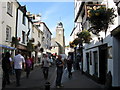
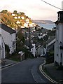
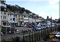
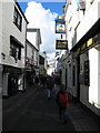
Photos of PL13 2AZ


Area Information
Living in PL13 2AZ offers a specific residential experience characterised by a compact footprint and a settled community. This postcode covers a small cluster of homes spanning only 1009 square metres, creating an intimate neighbourhood feel within Cornwall. You will find a population of 1528 residents sharing this limited space, which results in a population density of 400 people per square kilometre. This density suggests close proximity between houses without the scale of a large town centre. The area functions as a distinct residential pocket rather than a sprawling suburb, making it ideal for those who prefer a quiet existence yet remain within reach of wider local services. Understanding this scale helps you visualise daily life, where boundaries are defined clearly and the community is tightly knit. The character of this location is defined by its exclusivity of space and its integration into the surrounding landscape of East Cornwall. Prospective buyers often appreciate the clarity of the layout, knowing exactly what they are purchasing within these specific geographical limits.
- Area Type
- Postcode
- Area Size
- 1009 m²
- Population
- 1528
- Population Density
- 400 people/km²
The property market in PL13 2AZ is defined by its residential nature and high rate of private ownership. With 65 per cent of residents owning their homes, the area feels like a settled locality rather than a transient rental zone. Nearly all existing accommodation takes the form of houses, excluding flats and lodges from the primary housing stock. This concentration of house types aligns with the demographic of adults and families who have purchased properties for long-term residence. Buyers looking at this postcode should expect a mix of established dwellings suited to local lifestyles. The small size of the area means housing supply is limited, which often lends stability to prices in established neighbourhoods. Residents are likely to view properties as a primary home base rather than a temporary letting. This housing structure supports a quiet neighbourhood atmosphere where homes serve as permanent anchors for their owners.
House Prices in PL13 2AZ
Showing 5 properties
| Address | Type | Beds | Baths | Last Sale Price | Last Sale Date | |
|---|---|---|---|---|---|---|
| Charlecote, The Downs, West Looe, PL13 2AZ | Detached | 6 | 1 | - | - | |
| Captains Retreat, The Downs, West Looe, PL13 2AZ | Detached | 4 | 1 | - | - | |
| Captains Retreat, The Downs, West Looe, PL13 2AZ | Flat | - | - | - | - | |
| 1, Charlecote, The Downs, West Looe, PL13 2AZ | Flat | - | - | - | - | |
| 2, Charlecote, The Downs, West Looe, PL13 2AZ | Detached | - | - | - | - |
Energy Efficiency in PL13 2AZ
Residents of PL13 2AZ benefit from a cluster of amenities within practical reach, supporting daily shopping and local travel needs. There are five retail options nearby, including specific branches such as Co-op East, Spar, and Co-op Looe. These outlets handle everyday essentials for small households and families in the area. Beyond retail, the community has excellent transport links with five railway stations accessible for further travel. Notable stations include Looe Railway Station, Sandplace Railway Station, and Causeland Railway Station. These points provide convenient access to local towns and beyond, reducing the need for a car for short journeys. The combination of local supermarkets and multiple rail links creates a functional lifestyle where you can run errands close to home and travel further without significant hassle. This accessibility ensures that living in this small cluster does not isolate you from wider regional opportunities.
Amenities
Schools
| Rank | School | Type | Entry gender | Ages |
|---|
Explore more schools in this area
Go to Schools tabDemographics
The community in PL13 2AZ reflects a mature demographic profile with significant stability. The median age sits at 47 years, indicating a population dominated by adults between 30 and 64 years old. This age skew suggests the area appeals to families with grown children, empty nesters, and professionals seeking a quieter rural life rather than a high-energy student hub. Home ownership is the dominant housing tenure, standing at 65 per cent of households. This high level of ownership points to long-term residents who are invested in their local environment, fostering neighbours who know one another well. Accommodation primarily consists of houses, consistent with the older age profile and owner-occupier status. The predominant ethnic group is White, mirroring the traditional demographic patterns found in many coastal Cornish villages. These statistics confirm that PL13 2AZ is a established adult community with strong roots and a low turnover of very young children or temporary renters.
Household Size
Accommodation Type
Tenure
Ethnic Group
Religion
Household Composition
Age
Household Deprivation
NS-SEC
Explore more demographic insights in this area
Go to Demographics tabPlanning
Planning Constraints
- Flood RiskPremium
- Ramsar Wetland SitesPremium
- Area of Outstanding Natural BeautyPremium
- Protected Nature ReservePremium
- Protected WoodlandPremium