Area Overview for PL13 1LE
Photos of PL13 1LE


Area Information
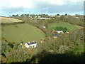
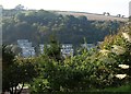
PL13 1LE represents a specific postcode area covering a small residential cluster of 18.5 hectares. This compact zone accommodates a population of 1,882 people, resulting in a density of 198 people per square kilometre. Living in PL13 1LE means inhabiting a defined neighbourhood where space is utilised efficiently without the sprawl of larger towns. The area functions as a self-contained residential environment, distinct from surrounding larger municipalities. Prospective buyers encounter a setting characterised by its small scale and concentrated community feel. The postcode serves as a geographical identifier for this specific group of housing within the broader Cornwall region. Daily life here revolves around proximity to immediate amenities and walking distance to local services. You can expect a neighbourhood where residents share common local features and a distinct sense of place. The area offers a clear definition of boundaries and a focused scope for those seeking a defined locality.
- Area Type
- Postcode
- Area Size
- 18.5 hectares
- Population
- 1882
- Population Density
- 198 people/km²
Looking at the property market in PL13 1LE, the 62 per cent home ownership rate is the defining characteristic of the housing landscape. This figure indicates that the area is primarily owner-occupied rather than a hub for short-term tenancies or student rentals. Most homes in PL13 1LE are houses, which presents a specific option for buyers seeking traditional accommodation. The accommodation type excludes flats as a dominant category, limiting availability for those requiring upper-storey living. For anyone looking at homes in PL13 1LE, the market consists largely of individual properties rather than blocks of flats. This structure supports families and households preferring ground-level access or detached living. The concentration of owner-occupied homes suggests stability and lower tenant turnover in the vicinity. Buyers here will find a market driven by local needs rather than investment speculation. The housing stock reflects the demographic reality of an area where adults settle and stay.
House Prices in PL13 1LE
Showing 36 properties
Energy Efficiency in PL13 1LE
Your lifestyle in PL13 1LE relies on a practical reach of five retail outlets and five railway stations positioned near your home. For daily shopping, you have access to Spar, Co-op East, and Co-op Looe, ensuring essential goods are available without travel. These three specific venues form the core of your local retail experience, satisfying most weekly needs. Commuters have rail access through Looe Railway Station, Sandplace Railway Station, and Causeland Railway Station, providing five total station options within practical distance. This rail network allows you to connect to broader regions without requiring a private vehicle for all journeys. Living in PL13 1LE means having supermarkets and train stations nearby, reducing reliance on cars for basic tasks. The combination of food stores and transport hubs creates a convenient self-sufficient environment. You can walk or take a short drive to reach these facilities, saving time on home ownership. Local convenience is built into the immediate vicinity of your property.
Amenities
Schools
Families considering PL13 1LE have access to a defined network of educational institutions immediately nearby. Looe Primary School and Looe Community School operate as primary schools within walking or short driving distance. Further education options include Looe Community Academy, which holds a good Ofsted rating, and Looe Primary Academy, also rated good by Ofsted. The presence of an academy alongside maintained schools provides variety in educational methodology and governance. The mixed provision of primary and academy schools gives parents a range of choices for their children's education. Both Looe Primary Academy and Looe Community Academy share the same positive Ofsted rating, offering reassurance on educational standards. This concentration of schools means parents rarely need to commute significant distances for schooling. The availability of both community-run and academy models ensures different teaching approaches are accessible. You can secure a good education standard for your children while living in this postcode.
| Rank | School | Type | Entry gender | Ages |
|---|
Explore more schools in this area
Go to Schools tabDemographics
The community within PL13 1LE reflects a mature demographic profile with a median age of 47 years. Adults aged between 30 and 64 years form the most common age range, indicating a population dominated by working-age families and established adults. Home ownership stands at 62 per cent, suggesting that a clear majority of residents own their properties outright or with a mortgage. This high rate of ownership contrasts with rental-heavy urban centres. Houses remain the predominant accommodation type, confirming the residential nature of the cluster. The predominant ethnic group is White, which aligns with broader regional demographics in Cornwall. You are buying into an area where long-term residents have established themselves over time. The age structure implies a neighbourhood likely active with parents, professionals, and retirees who require stable, family-sized housing. The data indicates a settled population less transient than major city hubs.
Household Size
Accommodation Type
Tenure
Ethnic Group
Religion
Household Composition
Age
Household Deprivation
NS-SEC
Explore more demographic insights in this area
Go to Demographics tabPlanning
Planning Constraints
- Flood RiskPremium
- Ramsar Wetland SitesPremium
- Area of Outstanding Natural BeautyPremium
- Protected Nature ReservePremium
- Protected WoodlandPremium