Area Overview for PL1 5RZ
Photos of PL1 5RZ


Area Information
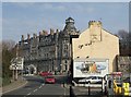
PL1 5RZ represents a specific postcode cluster within a small residential landscape, defined by its concentration in the broader Plymouth region. This micro-locale forms part of a larger urban fabric where residents navigate a mix of domestic and commuter living. The area encompasses a population of 1,809 individuals, creating a compact community environment distinct from the wider city sprawl. Life here revolves around proximity to key transport hubs and established local services, making it a practical choice for those prioritising access to amenities over rural seclusion. Residents benefit from the immediate availability of rail links, ferry terminals, and retail corners that serve their daily needs without extensive travel. The postcode functions as an entry point into a neighbourhood where the pace of life is dictated by urban convenience rather than countryside quiet. Prospective buyers view this location as a strategic base, offering a defined identity distinct from peripheral suburbs while remaining fully integrated into the city's practical infrastructure.
- Area Type
- Postcode
- Area Size
- Not available
- Population
- 1809
- Population Density
- 8033 people/km²
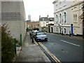
Housing in PL1 5RZ is typified by a predominance of flats, reflecting a built environment designed for density and urban living. With home ownership standing at just 21%, this postcode operates as a dynamic rental market where investment properties likely outnumber owner-occupied dwellings. Buyers looking for detached houses or semi-detached homes may need to look beyond this immediate cluster, as the local stock favours multi-occupancy units suited to the adult population aged 30 to 64. The low ownership rate implies a high turnover or a preference among residents to remain in flexible tenancy agreements rather than commit to long-term mortgages. This dynamic shapes the market for anyone seeking "homes in PL1 5RZ", as supply is focused on self-contained living arrangements within these smaller accommodation types.
House Prices in PL1 5RZ
Showing 1 properties
| Address | Type | Beds | Baths | Last Sale Price | Last Sale Date | |
|---|---|---|---|---|---|---|
| 31 Wyndham Street West, Plymouth, PL1 5RZ | Flat | - | - | - | - |
Energy Efficiency in PL1 5RZ
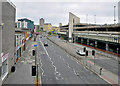
Daily life for those living in PL1 5RZ benefits from immediate access to essential retail and transport facilities. Residents have five retail options within practical reach, including Sainsburys Plymouth, Co-op Wilton, and Iceland Plymouth, ensuring access to groceries and daily necessities without lengthy commutes. Transport connectivity is anchored by five rail stations, namely Plymouth Railway Station, Devonport Railway Station, and Dockyard Railway Station, which serve as major interchange points. The area also boasts five ferry terminals, including Plymouth Ferry Terminal, Plymouth Stonehouse Ferry Terminal, and Plymouth Landing Stage, facilitating coastal travel. Additionally, two airports, both called Plymouth City Airport, are located nearby for air travel. This concentration of amenities creates a lifestyle where work, shopping, and leisure are all accessible within short distances.
Amenities
Schools
Families residing in PL1 5RZ have access to a mix of state and independent education options nearby. The Cathedral School of St Mary operates as a primary academy with an Ofsted rating of satisfactory, providing foundational education for younger children. For those seeking alternative educational pathways, St Dunstan's Abbey School serves as a nearby independent option, offering a different pedagogical approach. Older children have access to St Peter's CofE Secondary School, which completes the range of local formal education. This combination of institutions means that parents in this postcode have choices across the state and private sectors. The presence of both academy and faith-based schools indicates a diverse educational landscape within commuting distance of this residential cluster.
| Rank | School | Type | Entry gender | Ages |
|---|
Explore more schools in this area
Go to Schools tabDemographics
The community profile of PL1 5RZ reflects an established adult population with a median age of 47 years. Carers and workers aged between 30 and 64 years dominate this demographic, indicating a mature household structure rather than a young, expanding family cohort. Only 21% of people in this area own their homes, suggesting that the majority of residents operate within the rental sector or share accommodation. This significant private renting figure aligns with the prevalent accommodation type of flats, which characterises the built environment. White residents form the predominant ethnic group, mirroring the broader historical settlement patterns of the region. The lack of reported data on specific deprivation indices means one must rely on the visible housing stock to infer economic stability, though the high rate of flat ownership or tenancy points to diverse income levels among the 1,809 local residents.
Household Size
Accommodation Type
Tenure
Ethnic Group
Religion
Household Composition
Age
Household Deprivation
NS-SEC
Explore more demographic insights in this area
Go to Demographics tabPlanning
Planning Constraints
- Flood RiskPremium
- Ramsar Wetland SitesPremium
- Area of Outstanding Natural BeautyPremium
- Protected Nature ReservePremium
- Protected WoodlandPremium