Area Overview for PL1 5PH
Photos of PL1 5PH
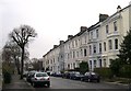
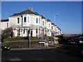
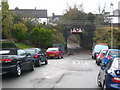
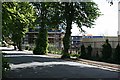

100 photos from this area
Area Information
Key information about the PL1 5PH including its size, population, and administrative classification.
- Area Type
- Postcode
- Area Size
- 9507 m²
- Population
- 1659
- Population Density
- 4578 people/km²
House Prices in PL1 5PH
64
Properties
£282,760
Average Sold Price
£75,000
Lowest Price
£411,000
Highest Price
Showing 64 properties
| Address | Type | Beds | Baths | Last Sale Price | Last Sale Date | |
|---|---|---|---|---|---|---|
| 18 Valletort Road, Plymouth, PL1 5PH | Terraced | 4 | 3 | £268,100 | Feb 2024 | |
| 24 Valletort Road, Plymouth, PL1 5PH | Semi-detached | 4 | 2 | £300,000 | Dec 2023 | |
| 15 Valletort Road, Plymouth, PL1 5PH | Terraced | 4 | 2 | £390,000 | Feb 2023 | |
| 41 Valletort Road, Plymouth, PL1 5PH | Semi-detached | - | - | £281,000 | Jul 2022 | |
| 8 Valletort Road, Plymouth, PL1 5PH | Terraced | 4 | 2 | £411,000 | Jun 2022 | |
| 21 Valletort Road, Plymouth, PL1 5PH | Terraced | 4 | 1 | £400,000 | Oct 2021 | |
| 16 Valletort Road, Plymouth, PL1 5PH | Semi-detached | 5 | 1 | £277,500 | Jul 2021 | |
| 29 Valletort Road, Plymouth, PL1 5PH | Terraced | 4 | 2 | £344,260 | Jun 2021 | |
| 17 Valletort Road, Plymouth, PL1 5PH | house | - | - | £400,000 | Feb 2021 | |
| 31 Valletort Road, Plymouth, PL1 5PH | Terraced | 4 | 2 | £380,000 | Nov 2020 |
Page 1 of 7
Energy Efficiency in PL1 5PH
Amenities
Schools
| Rank | School | Type | Entry gender | Ages |
|---|
Explore more schools in this area
Go to Schools tabDemographics
Household Size
One person
most common
Accommodation Type
Houses
most common
Tenure
65
majority
Ethnic Group
White
most common
Religion
N/A
most common
Household Composition
N/A
most common
Age
47
median
Adults (30-64 years)
most common
Household Deprivation
N/A
with no deprivation
NS-SEC
41
in Lower managerial occupations
Explore more demographic insights in this area
Go to Demographics tabPlanning
Planning Constraints
- Flood RiskPremium
- Ramsar Wetland SitesPremium
- Area of Outstanding Natural BeautyPremium
- Protected Nature ReservePremium
- Protected WoodlandPremium