Area Overview for Pittville Ward
Photos of Pittville Ward


Area Information
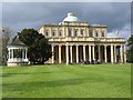
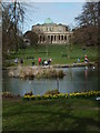
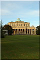
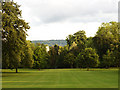
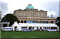
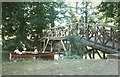
Pittville Ward stands as a distinctive residential suburb within the larger borough unitary structure of Cheltenham, Gloucestershire. This district spans a compact area of 1.6 km², offering a palm-sized footprint rich with historical texture rather than urban sprawl. The location, situated near coordinates 51.90833°N 2.06667°W, was deliberately established in the early 19th century by developer Joseph Pitt. He began estate development between 1824 and 1825 with the specific intent of creating a spa town rivaling Cheltenham's fashionable quarters. Architects like John Forbes designed key structures, including the Pittville Pump Room, which opened in 1830. The area's character remains defined by grand Regency and Victorian architecture, particularly the large houses found near green spaces such as Pittville Circus and Wellington Square. Prospective homebuyers find a neighbourhood where daily life revolves around these historic landmarks. Pittville Park, which opened to the public in 1894 after purchase by the Cheltenham Borough Council, provides a central hub for recreation. The park features ornamental and boating lakes established in 1827, alongside bridges, a boathouse café, and a nine-hole golf course. Living in Pittville Ward means engaging with a community built on nineteenth-century planning, where the physical environment includes notable periods homes like the former residence of Rowena Cade and the current Cotswold Grange hotel.
- Area Type
- District Borough Unitary Ward
- Area Size
- 1.6 km²
- Population
- Not available
- Population Density
- Not available
Demographics
The community profile of Pittville Ward reflects an area dominated by older residents. The median age across the ward sits at 70, indicating a significant proportion of the population is elderly. This demographic reality shapes the cultural and social rhythm of daily life within these boundaries. House ownership rates are notably high at 63%, suggesting a substantial shift towards stability and long-term residence rather than transient renting. With a total population count of 5,327 according to the 2011 Census, the ward operates at a low density relative to its historical development. The data does not provide a breakdown for specific age ranges other than the total median age, nor does it include statistics on ethnicity or religion. Consequently, the explicit diversity metrics, household composition figures, and accommodation type details remain beyond the scope of this specific dataset. However, the high ownership percentage implies that many inhabitants have spent considerable time settling into their properties. This contrasts with younger, mixed-income neighbourhoods where rental turnover often drives community turnover. In Pittville Ward, the social fabric appears anchored by those who have invested in owner-occupied homes, creating a settled environment where the median resident age defines the primary demographic character.
Household Size
Accommodation Type
Tenure
Ethnic Group
Religion
Household Composition
Age
Household Deprivation
NS-SEC
Explore more demographic insights in this area
Go to Demographics tabPlanning
Planning Constraints
- Flood RiskPremium
- Ramsar Wetland SitesPremium
- Area of Outstanding Natural BeautyPremium
- Protected Nature ReservePremium
- Protected WoodlandPremium
- Crime RiskPremium