Area Overview for Newton Poppleford
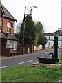
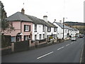
Photos of Newton Poppleford


Area Information
Newton Poppleford is a compact built-up area spanning 75.6 hectares, offering a quiet, established living environment in England. With a median age of 70, the community is predominantly older, suggesting a mature demographic profile. The area’s size is modest, which may contribute to a close-knit feel, though it remains connected to nearby towns via practical transport links. Daily life here is likely shaped by the proximity to amenities such as retail stores, rail services, and Exeter International Airport, which provides regional connectivity. The presence of a primary school with a ‘good’ Ofsted rating indicates that families with children have access to quality education, though secondary options are not specified. The area’s low crime risk score of 84 further enhances its appeal, offering residents a sense of security. For those seeking a peaceful, well-connected location with a mix of local services and ease of travel, Newton Poppleford presents a balanced option.
- Area Type
- Built Up Area 250
- Area Size
- 75.6 hectares
- Population
- Not available
- Population Density
- Not available
Newton Poppleford’s residents have access to a range of nearby amenities, including five retail outlets such as Waitrose Sidmouth, Morrisons Daily Ottery St, and Lidl Sidmouth. These stores offer convenience for daily shopping, while the two railway stations provide easy access to broader regional services. The proximity to Exeter International Airport adds to the area’s appeal for frequent travellers. Though the data does not mention parks or leisure facilities, the availability of retail and transport options suggests a lifestyle that balances local convenience with connectivity to larger urban centres.
Amenities
Schools
The nearest school to Newton Poppleford is Newton Poppleford Primary School, which is rated ‘good’ by Ofsted. This provides families with a reliable option for primary education within the area. While no secondary schools are listed, the presence of a primary school with a positive rating suggests that the community places value on education quality. Families requiring secondary schooling may need to look further afield, though the data does not specify nearby options. The availability of a well-rated primary school is a key factor for parents prioritising accessible, high-standard education for their children.
| Rank | A + A* % | School | Type | Entry gender | Ages |
|---|---|---|---|---|---|
| 1 | N/A | Newton Poppleford Primary School | primary | N/A | N/A |
Explore more schools in this area
Go to Schools tabDemographics
The population of Newton Poppleford is characterised by a median age of 70, reflecting a community that is largely composed of older residents. This demographic profile suggests a higher proportion of retired individuals or those in later life stages. Home ownership is strong, with 74% of households owning their properties, indicating a stable, long-term resident base. The data does not specify household composition or accommodation types, but the overall figures suggest a cohesive, settled population. The absence of detailed information on ethnic diversity or religious composition means these aspects cannot be elaborated. However, the high home ownership rate and the age profile together imply a community with a focus on comfort and familiarity, where residents may prioritise stability over frequent relocation.
Household Size
Accommodation Type
Tenure
Ethnic Group
Religion
Household Composition
Age
Household Deprivation
NS-SEC
Explore more demographic insights in this area
Go to Demographics tabPlanning
Planning Constraints
- Crime RiskLocked