Area Overview for GL8 8QS
Photos of GL8 8QS
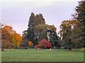

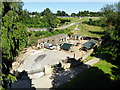
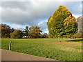
![Westonbirt Arboretum [1] in GL8 8QS](https://images.propbar.co.uk/images/geograph/52/26/5226931_120.jpg)
98 photos from this area
Area Information
Key information about the GL8 8QS including its size, population, and administrative classification.
- Area Type
- Postcode
- Area Size
- 63.3 hectares
- Population
- 1393
- Population Density
- 38 people/km²
House Prices in GL8 8QS
8
Properties
£1,468,000
Average Sold Price
£644,000
Lowest Price
£2,250,000
Highest Price
Showing 8 properties
| Address | Type | Beds | Baths | Last Sale Price | Last Sale Date | |
|---|---|---|---|---|---|---|
| Oak Tree House, 3/282 A 433 Westonbirt To Vancelletes Farm County Boundary, Westonbirt, GL8 8QS | Detached | 5 | 4 | £1,510,000 | Jul 2025 | |
| The Old Rectory, Bath Road, Westonbirt, GL8 8QS | retail_financial | - | - | £2,250,000 | Dec 2018 | |
| Primrose Hill, 3/282 A 433 Westonbirt To Vancelletes Farm County Boundary, Westonbirt, GL8 8QS | Detached | - | - | £644,000 | Mar 2005 | |
| Park Farm, Tetbury Road Sherston North To County Boundary, Westonbirt, GL8 8QS | warehouse | - | - | - | - | |
| Forest Enterprise : Dean, Westonbirt Arboretum, Road To Westonbirt Arboretum, Westonbirt, GL8 8QS | office_workshop | - | - | - | - | |
| 1, The Sleights, Road To Westonbirt Arboretum, Westonbirt, GL8 8QS | house | - | - | - | - | |
| 2, The Sleights, Road To Westonbirt Arboretum, Westonbirt, GL8 8QS | house | - | - | - | - | |
| Friends Of Westonbirt Arboretum, The Great Oak Hall, Westonbirt Arboretum, Road To Westonbirt Arboretum, Westonbirt, GL8 8QS | assembly_leisure | - | - | - | - |
Energy Efficiency in GL8 8QS
Amenities
Schools
| Rank | School | Type | Entry gender | Ages |
|---|
Explore more schools in this area
Go to Schools tabDemographics
Household Size
Two person
most common
Accommodation Type
Houses
most common
Tenure
79
majority
Ethnic Group
White
most common
Religion
N/A
most common
Household Composition
N/A
most common
Age
47
median
Adults (30-64 years)
most common
Household Deprivation
N/A
with no deprivation
NS-SEC
48
in Lower managerial occupations
Explore more demographic insights in this area
Go to Demographics tabPlanning
Planning Constraints
- Flood RiskPremium
- Ramsar Wetland SitesPremium
- Area of Outstanding Natural BeautyPremium
- Protected Nature ReservePremium
- Protected WoodlandPremium