Area Overview for GL53 7HQ
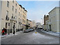
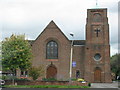
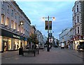
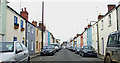
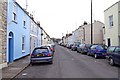
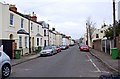
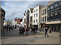
Photos of GL53 7HQ


Area Information
Living in GL53 7HQ offers a compact, residential experience within a small cluster of homes. With a population of 1,506, this postcode area is characterised by a balance of established housing and proximity to larger towns. The community is predominantly composed of adults aged 30–64, suggesting a mix of families and professionals. While the median age is 22, this likely reflects younger residents or students in the area. The presence of Cheltenham College, an independent school, hints at a focus on education, though it may cater to a broader regional catchment. Daily life here is shaped by nearby amenities, including major retailers like Sainsburys and Tesco, and transport links such as Cheltenham Spa Railway Station. The area’s broadband score of 92 ensures reliable internet, while mobile coverage of 85 supports connectivity. However, the crime risk is medium, with a safety score of 36, indicating the need for standard precautions. GL53 7HQ is a practical choice for those seeking a small, manageable area with access to essential services and transport options.
- Area Type
- Postcode
- Area Size
- Not available
- Population
- 1506
- Population Density
- 3799 people/km²
The property market in GL53 7HQ is dominated by owner-occupied homes, with 53% of residents owning their properties. Houses, rather than flats or apartments, are the primary accommodation type, indicating a focus on family-friendly housing. This suggests a market that caters to established households rather than renters or young professionals. The small population and limited housing stock mean the area is unlikely to have a large rental market. Buyers should consider that the housing stock is relatively uniform, with limited scope for new developments given the area’s size. Proximity to Cheltenham and its amenities may enhance property value, but the small scale of GL53 7HQ means competition for homes is likely to be limited. For those seeking a quiet, residential environment with access to nearby towns, this area could offer a stable investment.
House Prices in GL53 7HQ
Showing 2 properties
| Address | Type | Beds | Baths | Last Sale Price | Last Sale Date | |
|---|---|---|---|---|---|---|
| Ground And First Floor, 41 Bath Road, Cheltenham, GL53 7HQ | office_workshop | - | - | - | - | |
| 41 Bath Road, Cheltenham, GL53 7HQ | office_workshop | - | - | - | - |
Energy Efficiency in GL53 7HQ
Residents of GL53 7HQ have access to a range of amenities within practical reach. Retail options include Sainsburys Cheltenham, Iceland Cheltenham, and Tesco Cheltenham, ensuring everyday shopping needs are met. The Cheltenham Spa Railway Station provides rail access, while the nearby metro stops at Cheltenham Racecourse and Gotherington may offer alternative transport routes. Three airports are listed, though all are Gloucestershire Airport, which could be a point of interest for aviation enthusiasts. The area’s small size means amenities are concentrated, reducing the need for long commutes. However, the absence of parks or leisure facilities in the data suggests that outdoor recreation may require travel to nearby towns. The combination of retail and transport links creates a convenient, if modest, lifestyle for residents.
Amenities
Schools
The nearest school to GL53 7HQ is Cheltenham College, an independent institution. While no Ofsted rating is provided, its status as an independent school suggests it may cater to a specific demographic, potentially attracting families seeking private education. However, the absence of state schools in the data means families reliant on public education may need to look further afield. The presence of a single independent school indicates that GL53 7HQ’s educational options are limited to private institutions, which could influence decisions for homebuyers prioritising state school access. Parents should investigate whether Cheltenham College’s intake includes local residents or if it primarily serves a broader regional area.
| Rank | School | Type | Entry gender | Ages |
|---|
Explore more schools in this area
Go to Schools tabDemographics
The demographic profile of GL53 7HQ is defined by a median age of 22, though the most common age group is adults aged 30–64. This suggests a community skewed toward families and working professionals. Home ownership stands at 53%, with houses being the predominant accommodation type. The White ethnic group is the largest demographic, though specific diversity statistics are not provided. The area’s population size of 1,506 indicates a tight-knit, manageable community. While no data on deprivation is available, the medium crime risk score of 36 implies that residents should maintain standard security measures. The age distribution suggests a stable, long-term resident base, though the younger median age may reflect student populations or transient workers. This mix of demographics creates a dynamic but grounded local environment.
Household Size
Accommodation Type
Tenure
Ethnic Group
Religion
Household Composition
Age
Household Deprivation
NS-SEC
Explore more demographic insights in this area
Go to Demographics tabPlanning
Planning Constraints
- Flood RiskPremium
- Ramsar Wetland SitesPremium
- Area of Outstanding Natural BeautyPremium
- Protected Nature ReservePremium
- Protected WoodlandPremium