Area Overview for GL14 2SB
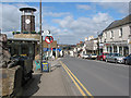
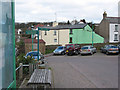
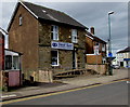
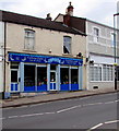
Photos of GL14 2SB


Area Information
Living in GL14 2SB offers a compact, residential experience shaped by its small cluster of homes and proximity to local amenities. With a population of 2,091 spread over a densely populated area—621 people per square kilometre—the community feels close-knit, yet it remains a quiet, low-rise neighbourhood. The area’s demographic profile suggests a mature population, with a median age of 47 and a majority of residents aged 30–64. This suggests a stable, family-oriented environment, with homes predominantly owner-occupied (62%) and focused on single-family housing. The absence of major planning constraints or environmental designations means development is unlikely to disrupt the existing character of the area. Residents benefit from nearby retail options, including Tesco Cinderford and Lidl Cinderford, while transport links such as the Dean Forest Railway provide connections to wider networks. For those prioritising safety, flood risk is minimal, though crime rates are average, requiring standard precautions. GL14 2SB is a practical choice for those seeking a balanced, low-maintenance lifestyle with access to essential services.
- Area Type
- Postcode
- Area Size
- Not available
- Population
- 2091
- Population Density
- 621 people/km²
The property market in GL14 2SB is characterised by a high rate of home ownership (62%) and a focus on single-family houses. This suggests a market driven by owner-occupiers rather than landlords, with properties likely to be older, traditional homes rather than modern apartments or high-rise developments. The small size of the area means the housing stock is limited, so buyers may need to consider nearby postcodes for more options. The absence of planning constraints or environmental protections allows for potential future development, though the current emphasis on houses indicates a preference for established, low-density living. For buyers, this means a market with fewer high-end properties but potentially more affordable options for those seeking a settled, family-friendly environment. The compact nature of the area also means proximity to amenities is a key selling point, with residents relying on nearby towns for additional services.
House Prices in GL14 2SB
No properties found in this postcode.
Energy Efficiency in GL14 2SB
Daily life in GL14 2SB is supported by a selection of nearby amenities that cater to practical needs. The area’s retail offerings include five venues, notably Tesco Cinderford, Lidl Cinderford, and Co-op Valley, providing essential shopping for groceries and household items. These stores are likely to serve not only residents of GL14 2SB but also surrounding areas, making them a central hub for local commerce. The presence of the Dean Forest Railway and Parkend adds to the area’s accessibility, offering transport options for travel beyond the immediate neighbourhood. While the data does not specify parks or leisure facilities, the proximity to these transport links suggests that residents can easily access recreational spaces in nearby towns. The combination of retail and transport options creates a lifestyle that prioritises convenience, allowing residents to manage daily errands and travel without significant inconvenience.
Amenities
Schools
The nearest school to GL14 2SB is Steam Mills Primary School, which serves the local community with a good Ofsted rating. As a primary school, it caters to children aged 4–11, making it a crucial resource for families with young children. The presence of a single primary school suggests that secondary education options may require commuting to nearby towns, though the school’s positive rating indicates quality teaching and facilities. For parents, the school’s performance is a significant factor in choosing GL14 2SB, as it provides a foundation for early education without the need for long-distance travel. However, the absence of secondary schools or other educational institutions within the area means families must plan for additional travel or consider proximity to larger towns with more comprehensive school networks.
| Rank | School | Type | Entry gender | Ages |
|---|
Explore more schools in this area
Go to Schools tabDemographics
The community in GL14 2SB is defined by its age structure and household composition. With a median age of 47 and the majority of residents aged between 30 and 64, the area is predominantly populated by working-age adults and older families. Home ownership stands at 62%, reflecting a mix of long-term residents and those settled in stable properties. The accommodation type is largely houses, indicating a preference for private, standalone living spaces. The predominant ethnic group is White, though no specific data on diversity or deprivation is provided. The absence of younger demographics or high-density housing suggests a focus on established households rather than student populations or rental-focused development. This profile aligns with a community prioritising stability and continuity, with limited turnover in property ownership. The age range also implies a need for local schools and healthcare services, which are partially met by the nearby Steam Mills Primary School.
Household Size
Accommodation Type
Tenure
Ethnic Group
Religion
Household Composition
Age
Household Deprivation
NS-SEC
Explore more demographic insights in this area
Go to Demographics tabPlanning
Planning Constraints
- Flood RiskPremium
- Ramsar Wetland SitesPremium
- Area of Outstanding Natural BeautyPremium
- Protected Nature ReservePremium
- Protected WoodlandPremium