Area Overview for EX39 2HZ
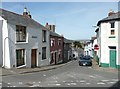
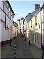
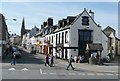
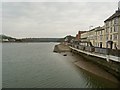
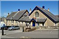
Photos of EX39 2HZ


Area Information
Living in EX39 2HZ means being part of a small, tightly knit residential cluster in England, home to 2140 people. This area is defined by its modest scale and proximity to coastal amenities, with a population that skews towards middle-aged adults. The community is largely built around traditional housing, reflecting a quieter, more settled way of life. Residents benefit from nearby ferry services, including Bideford, Instow, and Appledore landings, which offer direct access to local waters and surrounding towns. The Royal Marines Base Chivenor Airport nearby adds a unique layer to the area’s connectivity. Daily life here balances practicality with coastal charm, with shops like Co-op Bideford and Morrisons providing essentials. While the area lacks high-density development, its compact nature fosters a sense of familiarity, making it appealing to those seeking a slower pace without sacrificing access to key services.
- Area Type
- Postcode
- Area Size
- Not available
- Population
- 2140
- Population Density
- 6903 people/km²
The property market in EX39 2HZ is dominated by houses, with 45% of homes owned by residents. This suggests a balance between owner-occupied properties and rental stock, though the relatively low home ownership rate may indicate a higher proportion of tenants in the area. Given the small size of the postcode and its focus on houses, the housing stock is likely limited in volume, which could mean competition for available properties. Buyers should consider the area’s compact nature, as the immediate surroundings may offer few alternatives. The predominance of houses may appeal to those seeking family homes, but the small scale of the area means that property choices are constrained. Prospective buyers should also factor in the local amenities and transport links when assessing the value of properties here.
House Prices in EX39 2HZ
No properties found in this postcode.
Energy Efficiency in EX39 2HZ
Residents of EX39 2HZ have access to a range of amenities within practical reach. The area’s retail options include Co-op Bideford, Morrisons Daily Bideford 12/13, and Morrisons Bideford, ensuring everyday shopping needs are met. The three ferry landings—Bideford, Instow, and Appledore—offer convenient access to local waters, supporting both leisure activities and commuting. The Royal Marines Base Chivenor Airport, while not a public transport hub, underscores the area’s strategic location. The presence of multiple retail outlets and transport links contributes to a lifestyle that balances convenience with the tranquillity of a smaller community. For those who enjoy coastal living, the ferry services provide a direct link to nearby towns, enhancing the area’s appeal for both residents and visitors.
Amenities
Schools
| Rank | School | Type | Entry gender | Ages |
|---|
Explore more schools in this area
Go to Schools tabDemographics
The population of EX39 2HZ has a median age of 47, with the majority of residents aged between 30 and 64. This suggests a community of established adults, many of whom may be raising families or in their professional prime. Home ownership stands at 45%, indicating a mix of owner-occupied properties and rental units. The predominant accommodation type is houses, which aligns with the area’s residential character. The predominant ethnic group is White, reflecting a demographic profile typical of smaller rural or coastal communities. While no specific data on deprivation is provided, the lower home ownership rate may imply a reliance on rental markets or shared living arrangements. The age range and housing stock suggest a stable, long-term population rather than a transient one, with a focus on family-oriented living.
Household Size
Accommodation Type
Tenure
Ethnic Group
Religion
Household Composition
Age
Household Deprivation
NS-SEC
Explore more demographic insights in this area
Go to Demographics tabPlanning
Planning Constraints
- Flood RiskPremium
- Ramsar Wetland SitesPremium
- Area of Outstanding Natural BeautyPremium
- Protected Nature ReservePremium
- Protected WoodlandPremium