Area Overview for EX35 6EQ
Photos of EX35 6EQ
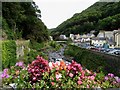
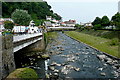
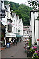
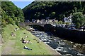
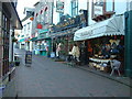
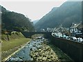
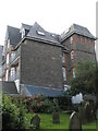
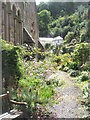
100 photos from this area
Area Information
Key information about the EX35 6EQ including its size, population, and administrative classification.
- Area Type
- Postcode
- Area Size
- 12.7 hectares
- Population
- 1608
- Population Density
- 24 people/km²
House Prices in EX35 6EQ
10
Properties
-
Average Sold Price
-
Lowest Price
-
Highest Price
Showing 10 properties
| Address | Type | Beds | Baths | Last Sale Price | Last Sale Date | |
|---|---|---|---|---|---|---|
| Flat 1, 1 The Esplanade, Lynmouth, EX35 6EQ | Maisonette | 3 | 2 | - | - | |
| H And H Enterprises, The Esplanade, Lynmouth, EX35 6EQ | Office | - | - | - | - | |
| Aladdins Cave, The Esplanade, Lynmouth, EX35 6EQ | retail_financial | - | - | - | - | |
| Flat 2, 1 The Esplanade, Lynmouth, EX35 6EQ | Flat | - | - | - | - | |
| First Floor, The Basket Shop, The Esplanade, Lynmouth, EX35 6EQ | Flat | - | - | - | - | |
| Esplanade Cafe, The Esplanade, Lynmouth, EX35 6EQ | Restaurant | - | - | - | - | |
| Hackney Carriage Rank, The Esplanade, Lynmouth, EX35 6EQ | commercial | - | - | - | - | |
| Exmoor National Park, The Esplanade, Lynmouth, EX35 6EQ | shop | - | - | - | - | |
| Historic Pier, The Esplanade, Lynmouth, EX35 6EQ | Leisure | - | - | - | - | |
| 1, Harbour Point, The Esplanade, Lynmouth, EX35 6EQ | Maisonette | - | - | - | - |
Energy Efficiency in EX35 6EQ
Amenities
Schools
| Rank | School | Type | Entry gender | Ages |
|---|
Explore more schools in this area
Go to Schools tabDemographics
Household Size
Two person
most common
Accommodation Type
Houses
most common
Tenure
69
majority
Ethnic Group
White
most common
Religion
N/A
most common
Household Composition
N/A
most common
Age
47
median
Adults (30-64 years)
most common
Household Deprivation
N/A
with no deprivation
NS-SEC
27
in Lower managerial occupations
Explore more demographic insights in this area
Go to Demographics tabPlanning
Planning Constraints
- Flood RiskPremium
- Ramsar Wetland SitesPremium
- Area of Outstanding Natural BeautyPremium
- Protected Nature ReservePremium
- Protected WoodlandPremium