Area Overview for EX2 8QW
Photos of EX2 8QW


Area Information
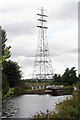
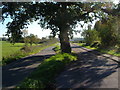
Living in EX2 8QW offers a compact, residential experience with a population of 1,221 spread across 9.7 hectares. This small postcode area is characterised by a mature demographic, with a median age of 47 and a strong presence of adults aged 30–64. The area’s density of 538 people per square kilometre suggests a tight-knit community, though its size means it is more of a cluster than a sprawling suburb. Proximity to multiple railway stations, including Exeter Central and Marsh Barton, and nearby retail hubs like Makro Exeter and Lidl Marsh, ensures practical connectivity. While the area lacks large-scale amenities, its location near Exeter International Airport and ferry landings at Topsham adds to its accessibility. Daily life here balances quiet residential living with the convenience of nearby transport and shopping. However, the high flood risk score of 100 and moderate crime risk score of 63 mean residents should consider these factors when evaluating long-term suitability.
- Area Type
- Postcode
- Area Size
- 9.7 hectares
- Population
- 1221
- Population Density
- 538 people/km²
The property market in EX2 8QW is dominated by owner-occupied homes, with 73% of residents owning their properties. The accommodation type is primarily houses, which is unusual for areas with limited space, suggesting a focus on single-family dwellings. Given the small area size of 9.7 hectares and the high home ownership rate, the housing stock is likely limited, making the market competitive for buyers. The proximity to Exeter’s transport links and retail hubs may enhance property value, but the area’s small size means buyers must consider immediate surroundings for additional options. With no rental data provided, it is unclear how many properties are available for let, but the high ownership rate implies a relatively stable market with fewer turnover opportunities.
House Prices in EX2 8QW
Showing 14 properties
Energy Efficiency in EX2 8QW
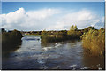
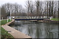
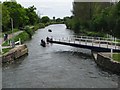
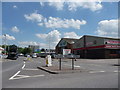
Residents of EX2 8QW have access to a range of nearby amenities, including five railway stations, four ferry landings, and retail outlets like Makro Exeter and Lidl Marsh. The presence of Exeter International Airport within reach adds to the area’s connectivity, though it does not offer direct retail or dining options. The ferry landings at Topsham Lock and Turf Lock Inn provide alternative transport routes, particularly for those relying on waterways. While the area lacks large parks or leisure facilities, its proximity to Exeter’s urban centres likely compensates with broader options. The practical reach of shops and transport makes daily life efficient, though the absence of protected natural areas or cultural landmarks means the lifestyle is more functional than scenic.
Amenities
Schools
| Rank | School | Type | Entry gender | Ages |
|---|
Explore more schools in this area
Go to Schools tabDemographics
The community in EX2 8QW is predominantly composed of adults aged 30–64, with a median age of 47. Home ownership is high, at 73%, and the accommodation type is largely houses, reflecting a stable, settled population. The predominant ethnic group is White, though specific data on diversity or deprivation is not provided. The population density of 538 people per square kilometre suggests a mix of family homes and single-occupancy properties, but the small area size means the community is closely knit. With no data on income levels or deprivation, it is unclear how this affects local services or quality of life. The age profile indicates a mature demographic, which may influence local amenities and social dynamics.
Household Size
Accommodation Type
Tenure
Ethnic Group
Religion
Household Composition
Age
Household Deprivation
NS-SEC
Explore more demographic insights in this area
Go to Demographics tabPlanning
Planning Constraints
- Flood RiskPremium
- Ramsar Wetland SitesPremium
- Area of Outstanding Natural BeautyPremium
- Protected Nature ReservePremium
- Protected WoodlandPremium