Area Overview for EX2 8LP
Photos of EX2 8LP
Area Information
Living in EX2 8LP means being part of a tightly knit residential cluster in England, where 1,221 residents occupy 1.9 hectares of land. The area’s population density of 538 people per square kilometre suggests a compact, community-oriented layout. This postcode is defined by its small-scale character, with homes dominating the accommodation type and a strong presence of owner-occupiers. Daily life here is shaped by proximity to practical amenities, from retail outlets like Makro Exeter and Lidl Marsh to rail services at Marsh Barton and Exeter St Thomas stations. The area’s strategic position near Exeter International Airport and multiple ferry landings, including Topsham Lock Ferry Landing, adds to its connectivity. While the population skews towards adults aged 30–64, the median age of 47 reflects a mature, stable demographic. Living here offers a balance of residential tranquillity and access to essential services, though the small size of the area means buyers may need to consider nearby surroundings for broader options.
- Area Type
- Postcode
- Area Size
- 1.9 hectares
- Population
- 1221
- Population Density
- 538 people/km²
The property market in EX2 8LP is characterised by a high rate of home ownership (73%), with houses forming the predominant accommodation type. This suggests a market skewed towards owner-occupiers rather than renters, reflecting the area’s appeal to families and long-term residents. The small size of the postcode—just 1.9 hectares—means the housing stock is limited, with most properties concentrated in a compact cluster. Buyers considering this area may find that the immediate surroundings offer additional options, particularly given the proximity to nearby towns and transport links. The presence of rail stations, such as Marsh Barton and Exeter St Thomas, and the accessibility to Exeter International Airport enhance the area’s desirability for commuters and those requiring connectivity. However, the limited land area means property availability is constrained, and potential buyers should consider the broader regional market for more choices.
House Prices in EX2 8LP
Showing 1 properties
| Address | Type | Beds | Baths | Last Sale Price | Last Sale Date | |
|---|---|---|---|---|---|---|
| Matford Dental Clinic, Unit 1, Venture Centre, Yeoford Way, Marsh Barton Trading Estate, Exeter, EX2 8LP | commercial | - | - | - | - |
Energy Efficiency in EX2 8LP
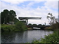
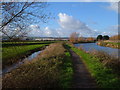
Residents of EX2 8LP have access to a range of amenities within practical reach, enhancing daily life. The area includes five retail outlets, such as Makro Exeter and Lidl Marsh, providing convenience for grocery shopping and everyday needs. Rail stations like Marsh Barton and Newcourt offer easy access to Exeter’s city centre and beyond, while ferry landings at Topsham Lock and Turf Lock Inn connect to nearby towns and countryside routes. The proximity to Exeter International Airport adds to the area’s appeal for those requiring air travel. These amenities create a lifestyle that balances local convenience with broader connectivity, supporting both routine errands and longer journeys. The presence of multiple transport options and retail hubs suggests a practical, accessible environment that caters to a variety of needs without requiring long commutes.
Amenities
Schools
| Rank | School | Type | Entry gender | Ages |
|---|
Explore more schools in this area
Go to Schools tabDemographics
The community in EX2 8LP is predominantly composed of adults aged 30–64, with a median age of 47. This suggests a mature population, likely with established careers and families. Home ownership is high, at 73%, indicating a strong presence of long-term residents. The area is largely made up of houses, which aligns with the demographic profile of settled households. The predominant ethnic group is White, reflecting a homogenous community. While specific data on deprivation is not provided, the high home ownership rate and stable age range suggest a relatively secure socioeconomic environment. However, the absence of detailed diversity metrics means the full extent of the area’s cultural composition remains unexplored. The population density of 538 people per square kilometre implies a mix of single-family homes and smaller dwellings, supporting a lifestyle that prioritises private space over high-density living.
Household Size
Accommodation Type
Tenure
Ethnic Group
Religion
Household Composition
Age
Household Deprivation
NS-SEC
Explore more demographic insights in this area
Go to Demographics tabPlanning
Planning Constraints
- Flood RiskPremium
- Ramsar Wetland SitesPremium
- Area of Outstanding Natural BeautyPremium
- Protected Nature ReservePremium
- Protected WoodlandPremium