Area Overview for EX10 0SD
Photos of EX10 0SD
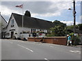

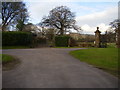
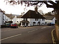
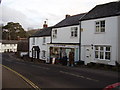

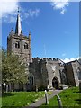
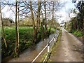
100 photos from this area
Area Information
Key information about the EX10 0SD including its size, population, and administrative classification.
- Area Type
- Postcode
- Area Size
- 9441 m²
- Population
- 2101
- Population Density
- 62 people/km²
House Prices in EX10 0SD
20
Properties
£244,350
Average Sold Price
£57,000
Lowest Price
£400,000
Highest Price
Showing 20 properties
| Address | Type | Beds | Baths | Last Sale Price | Last Sale Date | |
|---|---|---|---|---|---|---|
| Forge Cottage, Fore Street, Sidbury, EX10 0SD | Terraced | 3 | 1 | £375,000 | Jan 2024 | |
| Cherrytree Cottage, 30 Fore Street, Sidbury, EX10 0SD | Terraced | 2 | 1 | £220,000 | Mar 2021 | |
| The Old Coach House, Fore Street, Sidbury, EX10 0SD | house | - | - | £400,000 | Nov 2020 | |
| 103 Fore Street, Sidbury, EX10 0SD | Terraced | 4 | 1 | £285,000 | Dec 2018 | |
| The Old Post Office, 101 Fore Street, Sidbury, EX10 0SD | Terraced | 3 | 2 | £350,000 | Aug 2017 | |
| Old Clockhouse, 12 Fore Street, Sidbury, EX10 0SD | Terraced | 5 | - | £293,000 | Jun 2016 | |
| 106 Fore Street, Sidbury, EX10 0SD | Terraced | - | - | £187,500 | Jan 2004 | |
| Old Oak House, Fore Street, Sidbury, EX10 0SD | Terraced | 5 | 3 | £195,000 | May 2002 | |
| The Cherry Tree, 31 Fore Street, Sidbury, EX10 0SD | Cottage | 2 | - | £81,000 | Aug 1997 | |
| 105 Fore Street, Sidbury, EX10 0SD | Terraced | 3 | 1 | £57,000 | Nov 1996 |
Page 1 of 2
Energy Efficiency in EX10 0SD
Amenities
Schools
| Rank | School | Type | Entry gender | Ages |
|---|
Explore more schools in this area
Go to Schools tabDemographics
Household Size
Two person
most common
Accommodation Type
Houses
most common
Tenure
82
majority
Ethnic Group
White
most common
Religion
N/A
most common
Household Composition
N/A
most common
Age
47
median
Elderly (65+ years)
most common
Household Deprivation
N/A
with no deprivation
NS-SEC
47
in Lower managerial occupations
Explore more demographic insights in this area
Go to Demographics tabPlanning
Planning Constraints
- Flood RiskPremium
- Ramsar Wetland SitesPremium
- Area of Outstanding Natural BeautyPremium
- Protected Nature ReservePremium
- Protected WoodlandPremium