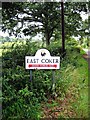
Area Overview for East Coker
Photos of East Coker
Area Information
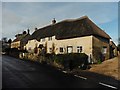
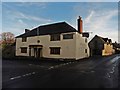
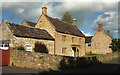
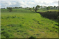
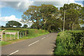
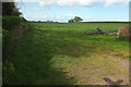
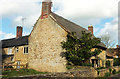
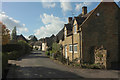
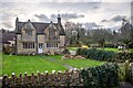
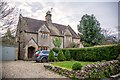
East Coker is a civil parish located in the South Somerset district, situated approximately two miles north of Yeovil. The settlement occupies an area of 8.0 km² and sits on a historic route that has facilitated movement through the region for centuries. You will find the village positioned in a setting shaped by Early British origins, where the soil and water sources supported settlement for over two millennia. The name derives from 'Cochra', indicating red arable land, reflecting the agricultural roots of the place. St Michael's Church stands as the historic focal point, dating back to approximately 1276 on Saxon foundations. Nearby, Grade 1 listed Coker Court represents the capital house of the East Coker manor, constructed by the powerful de Courtenay family in the mid-15th century. These structures anchor the landscape, offering a tangible link to the past. While the local economy historically centred on textile manufacturing along Coker Water, today the nearest significant commercial centre is Yeovil. This proximity allows residents access to wider opportunities while maintaining a rural character. Living in East Coker means engaging with a place where Roman mosaics once paved roads and where T.S. Eliot found inspiration for his Four Quartets. You are stepping into a community where history is not just recorded but embedded in the very fabric of the land and homes.
- Area Type
- Parish
- Area Size
- 8.0 km²
- Population
- Not available
- Population Density
- Not available
Demographics
The community in East Coker has a distinct age profile, with a median age of 70. This figure indicates a population skewed significantly towards older residents, suggesting the village is a retirement destination or a place where families move out as children grow. The household composition data confirms this trend, showing a total count that reflects a settled, mature demographic. Eighty-four per cent of homes in East Coker are owner-occupied. This high percentage of ownership implies a deep sense of stability and long-term commitment from those living there. The remaining 16 per cent are rented properties, indicating a small but present rental sector for those unable to buy. You will not find the transient nature of large rental districts here; instead, the housing stock is permeated by owners who have put down roots. The population of approximately 1,667, recorded in 2011, reinforces the feeling of a close-knit village rather than a sprawling suburb. High ownership rates often correlate with lower pressure for immediate capital gains, meaning prices are more likely to reflect usage rather than speculation. When considering who lives here, you are looking at a demographic that values permanence and likely shares a strong connection to the local land and heritage of the parish.
Household Size
Accommodation Type
Tenure
Ethnic Group
Religion
Household Composition
Age
Household Deprivation
NS-SEC
Explore more demographic insights in this area
Go to Demographics tabPlanning
Planning Constraints
- Flood RiskLocked
- Ramsar Wetland SitesLocked
- Area of Outstanding Natural BeautyLocked
- Protected Nature ReserveLocked
- Protected WoodlandLocked
- Crime RiskLocked