Area Overview for DT9 5EB
Photos of DT9 5EB
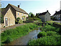
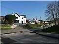
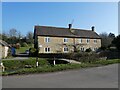
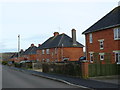
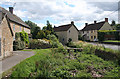
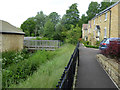
6 photos from this area
Area Information
Key information about the DT9 5EB including its size, population, and administrative classification.
- Area Type
- Postcode
- Area Size
- 1.6 hectares
- Population
- 1468
- Population Density
- 171 people/km²
House Prices in DT9 5EB
19
Properties
£270,000
Average Sold Price
£177,500
Lowest Price
£440,000
Highest Price
Showing 19 properties
| Address | Type | Beds | Baths | Last Sale Price | Last Sale Date | |
|---|---|---|---|---|---|---|
| The Forge, Higher Kingsbury, Milborne Port, DT9 5EB | house | 3 | - | £275,000 | Aug 2018 | |
| Sunnybank, Higher Kingsbury, Milborne Port, DT9 5EB | Bungalow | 3 | - | £360,000 | Sep 2013 | |
| Bethany, Higher Kingsbury, Milborne Port, DT9 5EB | Land | - | - | £202,500 | Jul 2011 | |
| 1 Higher Kingsbury, Milborne Port, DT9 5EB | house | 3 | - | £177,500 | Feb 2011 | |
| Bay Tree Cottage, Higher Kingsbury, Milborne Port, DT9 5EB | house | 3 | - | £238,000 | May 2010 | |
| Higher Kingsbury Farm, Higher Kingsbury, Milborne Port, DT9 5EB | Semi-detached | 4 | 2 | £440,000 | Jul 2004 | |
| Stepping Stones, Higher Kingsbury, Milborne Port, DT9 5EB | Detached | - | - | £197,000 | Dec 1999 | |
| The Coach House, Higher Kingsbury, Milborne Port, DT9 5EB | Detached | 4 | - | - | - | |
| Offices A To D, Clark House, Higher Kingsbury, Milborne Port, DT9 5EB | Office | - | - | - | - | |
| Pellextra Ltd, Clark House, Higher Kingsbury, Milborne Port, DT9 5EB | Office | - | - | - | - |
Page 1 of 2
Energy Efficiency in DT9 5EB
Amenities
Schools
| Rank | School | Type | Entry gender | Ages |
|---|
Explore more schools in this area
Go to Schools tabDemographics
Household Size
Two person
most common
Accommodation Type
Houses
most common
Tenure
79
majority
Ethnic Group
White
most common
Religion
N/A
most common
Household Composition
N/A
most common
Age
47
median
Adults (30-64 years)
most common
Household Deprivation
N/A
with no deprivation
NS-SEC
38
in Lower managerial occupations
Explore more demographic insights in this area
Go to Demographics tabPlanning
Planning Constraints
- Flood RiskPremium
- Ramsar Wetland SitesPremium
- Area of Outstanding Natural BeautyPremium
- Protected Nature ReservePremium
- Protected WoodlandPremium