Area Overview for DT11 7YT
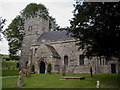
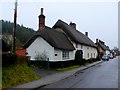
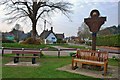
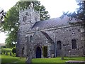
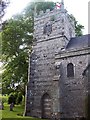
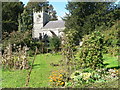
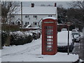
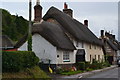
Photos of DT11 7YT


Area Information
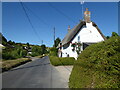
Living in DT11 7YT means inhabiting a small, tightly knit residential cluster in England, where the population of 1,967 spreads across 42 people per square kilometre. This is a quiet, low-density area, ideal for those seeking space without isolation. The community is characterised by a mature demographic, with a median age of 47 and a majority of residents aged 30–64. Daily life here is shaped by proximity to essential services, including five retail outlets such as Morrisons Blandford and Spar, and a network of schools that cater to primary education. The area’s safety profile is strong, with low crime risk and no flood or environmental hazards. While it lacks major urban infrastructure, its charm lies in its simplicity: a place where homes are predominantly owner-occupied, and the pace of life is measured. For buyers, DT11 7YT offers a snapshot of rural living with the convenience of nearby amenities, though its small size means choices are limited to those who prioritise tranquillity over sprawling development.
- Area Type
- Postcode
- Area Size
- Not available
- Population
- 1967
- Population Density
- 42 people/km²
The property market in DT11 7YT is dominated by owner-occupied homes, with 75% of properties in private hands. This suggests a stable market where long-term residency is common, and rental demand is likely limited. The accommodation type is primarily houses, which contrasts with areas where flats or apartments predominate. Given the small population and low density, the housing stock is constrained, meaning buyers may find a tight market with limited options. The area’s size—described as a “small residential cluster”—implies that property values are influenced by local amenities rather than broader economic trends. For buyers, this means competition for available homes could be fierce, though the emphasis on owner-occupation may indicate strong retention rates. The lack of high-rise or multi-unit developments also means the area is unlikely to attract speculative investment, preserving its character as a low-density, family-focused neighbourhood.
House Prices in DT11 7YT
No properties found in this postcode.
Energy Efficiency in DT11 7YT
The lifestyle in DT11 7YT is shaped by its proximity to essential retail and food services, including Morrisons Blandford, Spar, and Iceland Blandford. These stores provide a range of shopping and grocery needs, supporting a self-sufficient daily routine. While the area lacks detailed data on dining or leisure options, the presence of multiple retail outlets suggests a focus on convenience over luxury. The low population density means social spaces are likely limited to local parks or community hubs not specified in the data. For residents, this translates to a practical, no-frills lifestyle where essentials are accessible but entertainment and cultural amenities may require travel. The area’s charm lies in its simplicity: a place where daily life revolves around nearby shops, schools, and the quiet rhythm of rural living.
Amenities
Schools
Residents of DT11 7YT have access to three primary schools within practical reach: Okeford Fitzpaine Church of England Voluntary Aided School, Winterborne Stickland First School, and Okeford Fitzpaine Church of England School, which operates as an academy. These institutions provide a range of educational options, though no secondary schools are listed in the data. The presence of two primary schools suggests a focus on early education, with the academy offering a potentially broader curriculum or governance model. For families, this mix of school types ensures proximity to foundational learning, though parents seeking secondary education may need to look further afield. The lack of data on Ofsted ratings means the quality of education cannot be assessed here, but the variety of schools indicates an effort to meet local needs.
| Rank | School | Type | Entry gender | Ages |
|---|
Explore more schools in this area
Go to Schools tabDemographics
The population of DT11 7YT is predominantly adults aged 30–64, reflecting a mature community with a median age of 47. Home ownership is high at 75%, indicating a stable, long-term resident base. The area is composed largely of houses rather than flats, aligning with the preference of older households and families. The predominant ethnic group is White, with no specific data on other demographics provided. This composition suggests a community focused on established living, with fewer transient residents. The low population density of 42 people per square kilometre implies a spread-out, possibly rural or semi-rural setting, where privacy and space are prioritised. For quality of life, this translates to lower congestion and a slower pace, though it may limit access to high-density services. The absence of detailed diversity metrics means the area’s social fabric is understood through the lens of its core demographic, which is largely homogenous and family-oriented.
Household Size
Accommodation Type
Tenure
Ethnic Group
Religion
Household Composition
Age
Household Deprivation
NS-SEC
Explore more demographic insights in this area
Go to Demographics tabPlanning
Planning Constraints
- Flood RiskPremium
- Ramsar Wetland SitesPremium
- Area of Outstanding Natural BeautyPremium
- Protected Nature ReservePremium
- Protected WoodlandPremium