Area Overview for DT10 9BT
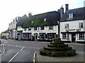
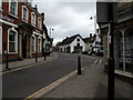
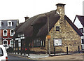
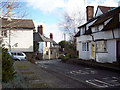
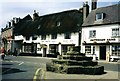
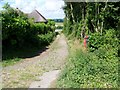
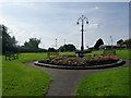
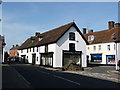
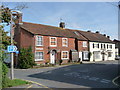
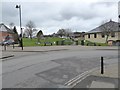
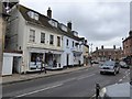
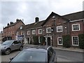
Photos of DT10 9BT
Area Information
Living in DT10 9BT offers a quiet, small-scale residential experience in a cluster of homes spread across a defined postcode area. With a population of 1,334, this is a tightly knit community where daily life revolves around local amenities and nearby schools. The area’s character is shaped by its modest size and the prevalence of houses, which suggest a stable, family-oriented environment. Residents here are predominantly adults aged 30–64, with a median age of 47, indicating a mature demographic that may prioritise established living over transient lifestyles. The presence of William Barnes Primary School, rated good by Ofsted, adds to the area’s appeal for families. While DT10 9BT lacks large-scale infrastructure, its proximity to retail outlets like The Southern Co-operative and Spar ensures practical convenience. For those seeking a low-maintenance, community-focused lifestyle, this area balances simplicity with essential services.
- Area Type
- Postcode
- Area Size
- Not available
- Population
- Not available
- Population Density
- Not available
The property market in DT10 9BT is characterised by a 49% home ownership rate, suggesting a balance between owner-occupied homes and rental properties. The area’s housing stock is predominantly composed of houses, which are more common than flats or apartments. This configuration points to a residential cluster that likely caters to families and individuals seeking traditional, standalone homes. Given the small size of the postcode area, the housing market is unlikely to be highly competitive, but buyers should consider the limited availability of properties. The focus on houses implies that the area may not be a hotspot for investors seeking high-density developments. For those prioritising proximity to local amenities and schools, DT10 9BT’s immediate surroundings offer practical advantages, though the market remains niche due to its constrained size.
House Prices in DT10 9BT
No properties found in this postcode.
Energy Efficiency in DT10 9BT
Daily life in DT10 9BT is shaped by its proximity to practical amenities, including five retail outlets such as The Southern Co-operative, Spar, and Co-op Shillingstone. These shops provide access to essentials like groceries and household items, reducing the need for long trips. The area’s small size means these venues are likely within walking distance for most residents, enhancing convenience. However, the data does not mention parks, leisure facilities, or dining options, so the full range of lifestyle offerings remains unclear. The presence of local retail suggests a community-oriented approach to shopping, but those seeking more extensive leisure or entertainment options may need to look beyond the immediate area.
Amenities
Schools
The nearest school to DT10 9BT is William Barnes Primary School, a primary institution rated good by Ofsted. This school serves the local community, providing education for younger children and offering a benchmark of quality for families considering the area. The absence of secondary schools or other educational institutions in the data means that students may need to travel beyond DT10 9BT for higher education. However, the presence of a well-rated primary school could be a significant draw for families prioritising early education. The single school listed highlights the area’s limited educational infrastructure, which may influence decisions about long-term residency, particularly for households with children requiring a broader range of schooling options.
| Rank | School | Type | Entry gender | Ages |
|---|
Explore more schools in this area
Go to Schools tabDemographics
The community in DT10 9BT is defined by its age profile and household composition. The median age of 47 suggests a population skewed towards middle-aged and older adults, with the majority (30–64 years) forming the most common age range. Home ownership stands at 49%, indicating a mix of owner-occupied properties and rental units. The accommodation type is predominantly houses, which aligns with the area’s small-scale, residential nature. The predominant ethnic group is White, reflecting a homogenous demographic. With a population of 1,334, the community is compact, which may foster a sense of familiarity among residents. However, the data does not provide specific information on deprivation levels, so it is unclear how economic factors influence quality of life. The absence of detailed diversity metrics means the area’s social fabric remains largely unexplored in this context.
Household Size
Accommodation Type
Tenure
Ethnic Group
Religion
Household Composition
Age
Household Deprivation
NS-SEC
Explore more demographic insights in this area
Go to Demographics tabPlanning
Planning Constraints
- Flood RiskPremium
- Ramsar Wetland SitesPremium
- Area of Outstanding Natural BeautyPremium
- Protected Nature ReservePremium
- Protected WoodlandPremium