Area Overview for Charfield
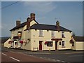
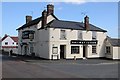
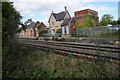
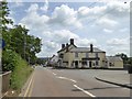
Photos of Charfield


Area Information
Charfield is a compact built-up area in England, covering 89.8 hectares. Its population, while not explicitly stated, is reflected in its demographic profile, with a median age of 70, suggesting a community skewed towards older residents. The area’s small size and low crime risk—scoring 82 out of 100—make it an appealing choice for those prioritising safety and stability. Daily life in Charfield is shaped by its proximity to essential services, including a railway station and several retail outlets. The high home ownership rate of 81% indicates a settled population, many of whom likely reside in long-standing properties. While the area lacks large-scale amenities, its practical connectivity and low crime levels offer a quiet, secure environment. For buyers seeking a low-maintenance lifestyle with access to basic needs, Charfield provides a straightforward, no-frills option. The presence of a highly rated primary school adds to its appeal for families, though the broader educational landscape remains limited. Overall, Charfield is a place where simplicity and safety are prioritised over urban vibrancy.
- Area Type
- Built Up Area 250
- Area Size
- 89.8 hectares
- Population
- Not available
- Population Density
- Not available
The lifestyle in Charfield is shaped by its proximity to essential amenities. Within practical reach are several retail outlets, including Spar Avon, Spar, and Co-op Wotton, which provide everyday shopping options. The Yate Railway Station offers access to regional travel, making it easier to reach larger towns or cities for work, leisure, or services not available locally. While the area lacks detailed information on parks or leisure facilities, the presence of these amenities suggests a focus on convenience over expansive recreational spaces. The combination of retail access and rail connectivity allows residents to maintain a self-sufficient lifestyle with minimal need to travel far from home. This makes Charfield suitable for those who prioritise ease of access to basic services over extensive leisure opportunities.
Amenities
Schools
The nearest school to Charfield is Charfield Primary School, which serves the local community. The school is listed with an Ofsted rating of outstanding, indicating high educational standards. As a primary school, it caters to younger children, but the data does not mention secondary education options nearby. The presence of a highly rated primary school is a significant advantage for families, though the absence of secondary schools means parents may need to consider commuting for older children. The school’s rating suggests that educational quality is a strength of the area, but the limited range of schools may be a consideration for those requiring a full spectrum of educational provision.
| Rank | School | Type | Entry gender | Ages |
|---|
Explore more schools in this area
Go to Schools tabDemographics
The population of Charfield is predominantly older, with a median age of 70. This suggests a community where retirees or long-term residents form the majority. Home ownership is high at 81%, indicating that most residents live in properties they own rather than rent. The data does not specify household types or accommodation categories, but the overall figures suggest a stable, low-turnover demographic. The absence of detailed breakdowns on ethnicity or religion means the area’s diversity remains unspecified, though the figures provided imply a homogenous population. The age profile and ownership statistics together suggest a community with limited generational turnover, which may influence local dynamics and service needs. For those considering Charfield, the demographic profile aligns with a preference for established, low-risk living rather than a rapidly changing environment.
Household Size
Accommodation Type
Tenure
Ethnic Group
Religion
Household Composition
Age
Household Deprivation
NS-SEC
Explore more demographic insights in this area
Go to Demographics tabPlanning
Planning Constraints
- Crime RiskPremium