Area Overview for BS99 7AQ
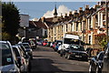
Photos of BS99 7AQ


Area Information
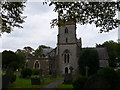
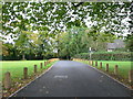
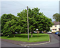
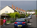
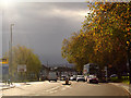
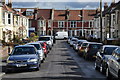
BS99 7AQ lies in northern Bristol, within the Lockleaze Ward, a post-war housing estate developed in the late 1940s and early 1950s to address the city’s housing needs. This small residential cluster, home to 1,722 people, blends suburban tranquillity with urban proximity, situated 3 miles north of Bristol’s city centre. The area features 1930s and 1950s council homes, many pre-cast concrete structures, and is bordered by green spaces like Stoke Park and Purdown. Notable landmarks include the Purdown BT Tower and remnants of the WWII anti-aircraft battery, ‘Purdown Percy’. The community is active, with initiatives like the Lockleaze Neighbourhood Trust addressing local issues such as road safety and climate action. While the area has a distinct post-war character, it is evolving through planning efforts, aiming to balance housing, employment, and connectivity to the city. Residents benefit from proximity to transport links, retail, and cultural sites, though challenges like childcare shortages persist.
- Area Type
- Postcode
- Area Size
- Not available
- Population
- 1722
- Population Density
- 4096 people/km²
The property market in BS99 7AQ is characterised by a 60% home ownership rate, with houses forming the majority of the accommodation stock. This indicates a community of long-term residents rather than a transient rental market. The post-war housing stock, including pre-cast concrete structures, reflects the area’s origins as a 1930s–1950s council estate. While the small population and limited area mean the housing stock is not vast, the focus on owner-occupied homes suggests stability. Buyers should consider the proximity to green spaces and transport links, though the area’s small size may require looking to nearby wards for additional options. The presence of community-led projects, such as new playgrounds, hints at ongoing investment, though property values may remain modest compared to central Bristol.
House Prices in BS99 7AQ
No properties found in this postcode.
Energy Efficiency in BS99 7AQ
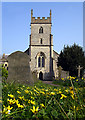
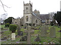
Living in BS99 7AQ offers access to a range of amenities within practical reach. Retail options include Lidl Horfield, Aldi Petherbrige Way, and Co-op Bristol, ensuring everyday shopping needs are met. The area’s transport links, including multiple rail and ferry options, connect residents to Bristol’s cultural and commercial hubs. Parks and green spaces, such as Stoke Park and Purdown, provide opportunities for outdoor activity. Community facilities like The Vench playground and St Mary’s Church reflect the area’s social fabric. While dining options are not explicitly listed, the proximity to central Bristol suggests a variety of restaurants and cafes within a short journey. The blend of suburban calm and urban accessibility makes daily life both convenient and connected.
Amenities
Schools
| Rank | School | Type | Entry gender | Ages |
|---|
Explore more schools in this area
Go to Schools tabDemographics
The population of BS99 7AQ has a median age of 47, with the most common age range being adults aged 30–64. This suggests a mature, stable community, likely with established families and professionals. Home ownership stands at 60%, with houses being the predominant accommodation type. The area’s demographic is predominantly White, reflecting broader trends in northern Bristol. While no specific deprivation data is provided, the presence of community initiatives like the Lockleaze Neighbourhood Trust indicates efforts to address local needs. The age profile and ownership rates suggest a mix of long-term residents and those seeking affordable housing in a semi-rural setting. The lack of high-rise or rental-focused developments points to a more family-oriented, owner-occupied environment.
Household Size
Accommodation Type
Tenure
Ethnic Group
Religion
Household Composition
Age
Household Deprivation
NS-SEC
Explore more demographic insights in this area
Go to Demographics tabPlanning
Planning Constraints
- Flood RiskPremium
- Ramsar Wetland SitesPremium
- Area of Outstanding Natural BeautyPremium
- Protected Nature ReservePremium
- Protected WoodlandPremium