Area Overview for BS7 0HP
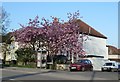
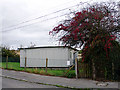
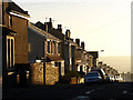
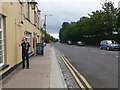
Photos of BS7 0HP


Area Information
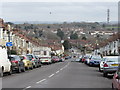
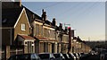
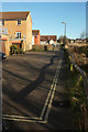
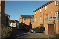
The postcode BS7 0HP defines a specific residential cluster within the wider Horfield area of Bristol. This small district spans just 6,823 square metres and is home to a population of 1,859 residents. Living in BS7 0HP means residing in a compact environment where the pace is dictated by nearby major thoroughfares like the A38 Gloucester Road and the historical presence of Southmead Hospital. The location holds deep roots, evolving from an agricultural parish recorded in the Domesday Book into a suburban hub characterised by rapid population growth in the late 19th century. While parts of historical Horfield, such as the Horfield Common and Horfield Prison, fall within adjacent administrative wards, the immediate BS7 0HP territory offers a tightly knit setting. The name itself derives from Old English 'horu', describing a muddy stretch of open land that has long since transformed into established housing. Although you may not find vast green fields in this precise postcode boundary, the area shares a connection with Monks Park and serves as a gateway to the broader Horfield district. Buying a home here grants you access to a community that balances historical significance with modern suburban便利性, situated close to Filton Abbey Wood and the industrial zones of Oldland. The density concentrates living spaces, creating a sense of place that is distinct from the sprawling outskirts of the city. You are moving into an area defined by a very young demographic profile. The median age for residents is 22 years, making the 15 to 29 age range the most common group. This indicates a neighbourhood populated largely by young adults rather than families with older children or retirees. Home ownership stands at 53%, suggesting a balanced market where nearly half of the residents own their properties while the other half rent. Houses form the predominant type of accommodation in this cluster, contrasting with the flats common in denser urban centres. The ethnic makeup is predominantly White, reflecting the historical development patterns of the Horfield ward. With a population concentration of 272,458 people per square kilometre across the specific 6,823 square metres, the area feels densely occupied. This high density combined with the young age profile creates a vibrant, energetic community atmosphere. You will likely encounter a transient yet engaged group of neighbours, many of whom are students or young professionals navigating their early careers. The high home ownership rate amongst young adults suggests a strong tendency to settle down and build roots in this specific part of Bristol rather than viewing it solely as a temporary stopover. Homes in BS7 0HP are primarily detached or semi-detached structures, with houses making up the vast majority of the local stock. The area is characterised by owner-occupancy, with a solid 53% of households holding the deed to their property. This ownership level signals a stable residential environment where residents are invested in the long-term maintenance and improvement of their homes. When looking at properties near BS7 0HP, you will notice that the small footprint of the postcode area interacts with the wider Horfield market. The accommodation type reflects a suburban legacy, distinct from the high-rise developments found deeper in the city centre. For a buyer, this means a market focused on traditional dwelling types rather than conversion projects or commercial-to-residential listings. The 53% ownership figure is a key metric for understanding who buys here; it suggests a significant portion of transactions involves existing homeowners upgrading or selling rather than a landlord-dominated rental sector. If you are considering investing, a strong owner-occupancy rate often indicates community stability and lower turnover compared to areas where landlords dominate. The housing stock aligns with the area's history of 19th-century expansion and subsequent suburbanisation, offering a settled character that appeals to those seeking a house rather than a flat. Digital connectivity in this location is rated as excellent, with a fixed broadband score of 99 out of 100. Mobile coverage is also very strong, scoring 85 out of 100. These indices place BS7 0HP among the most connected residential zones available. Such connectivity supports high-bandwidth activities essential for modern home life, including remote work, video conferencing, and large file transfers. Residents can rely on consistent internet speeds for streaming and online education without interruption. However, physical transport relies heavily on the A38 Gloucester Road, which runs through the centre of the nearby ward. You have access to several railway stations within practical reach, including Filton Abbey Wood, Ashley Down, and Montpelier. These rail links connect you directly to the city centre and other key hubs. Bristol Filton Airport is another local amenity situated near the area, offering flight options for those needing air travel. You can also access public transport via the Oldland Metro station. For daily commuting, the combination of excellent digital infrastructure and multiple rail options ensures you can maintain flexible working arrangements. Whether you are working from home or travelling to Andover or Filton, the connectivity options are robust. Your lifestyle in BS7 0HP is defined by proximity to well-established retail and leisure facilities. Within practical reach, you will find five notable retail locations, including Co-op Horfield, Tesco Bristol, and M&S Southmead. These supermarkets and high-street brands provide for your essential shopping needs without requiring a long journey into the city. For travel enthusiasts, there are five ferry landing points nearby, such as Castle Park and Temple Bridge, though these offer boat rides across the city rather than international travel. Rail travel is convenient, with five stations serving the broader Horfield and Bishopston areas, including Filton Abbey Wood and Ashley Down. You can reach five ferry services by walking or driving a short distance. Sporting culture is woven into the fabric of the region, centred on The Memorial Stadium, which has been the home of Bristol Rovers Football Club since 1996. The Memorial Stadium was originally built in 1921 to honour rugby union players who died in the First World War. While Horfield Common is administratively part of the adjacent Bishopston ward, it remains a key green space influencing the local character. The area also benefits from historical architecture, with Horfield Barracks and Horfield Prison standing as significant landmarks nearby. Caroling history, Cary Grant was born in this ward in 1904, adding a layer of cultural interest for residents who appreciate local heritage. Residents can feel reassured about their safety, with a crime risk assessment score of 80 out of 100, indicating a low crime rate. This area has below-average crime rates compared to national figures, making it a safe neighbourhood for families and individuals alike. The safety score places BS7 0HP in a positive category for property owners and tenants. Environmental hazards are minimal; there is a low flood risk coverage with a score of 0, meaning the area does not face significant threats from waterlogging. You do not need to worry about planning constraints related to protected natural sites, as there is no Ramsar wetland coverage. The area also lacks any designated Areas of Outstanding Natural Beauty, protected nature reserves, or protected woodland within its boundaries. These clear assessments mean you face very few regulatory hurdles if you wish to develop or modify your property. The absence of flood risk and environmental restrictions simplifies the planning process significantly. While the population density is high, the low crime score suggests that the community manages its safety well. The historical presence of institutions like Southmead Hospital and Horfield Prison contributes to a sturdy, established infrastructure that has stood the test of time without introducing modern environmental liabilities. Who typically lives in BS7 0HP and what is the community like?The community is dominated by young adults, with a median age of 22 years. The 15 to 29 age range is the most common, creating an energetic atmosphere. Home ownership is strong at 53%, indicating that many young people choose to buy rather than rent. The predominant ethnic group is White, and the area consists mainly of houses. This demographic mix suggests a vibrant, transitional neighbourhood where residents are often early in their careers or lives. How reliable are the internet and mobile phone services in BS7 0HP?Digital connectivity is rated as excellent. The fixed broadband score is 99 out of 100, providing server-grade speeds suitable for heavy streaming and remote work. Mobile coverage scores 85 out of 100, ensuring you stay connected even when outside your home. These metrics mean you will experience minimal downtime and high reliability for all digital needs, whether you are working from home or staying in touch with family. Is BS7 0HP a safe place to call home?Safety levels are high with a crime risk score of 80 out of 100. This indicates below-average crime rates for the country, categorising the area as a low-crime neighbourhood. There are no significant environmental risks either; the area has a flood risk score of 0 and lacks any Ramsar wetlands or protected nature reserves. The absence of these constraints means you face very few planning hurdles and can sleep safely knowing the grounds are secure. What shops and transport links are available nearby?You have immediate access to five retail outlets, including Co-op Horfield, Tesco Bristol, and M&S Southmead. Transport options are extensive, with five railway stations like Filton Abbey Wood and Ashley Down within reach. There is also one airport, Bristol Filton Airport, and five ferry landing points nearby. The main road, Gloucester Road, acts as the primary artery. This network ensures you can shop for essentials or commute via rail without needing to travel far into the city centre.
- Area Type
- Postcode
- Area Size
- 6823 m²
- Population
- Not available
- Population Density
- Not available
Homes in BS7 0HP are primarily detached or semi-detached structures, with houses making up the vast majority of the local stock. The area is characterised by owner-occupancy, with a solid 53% of households holding the deed to their property. This ownership level signals a stable residential environment where residents are invested in the long-term maintenance and improvement of their homes. When looking at properties near BS7 0HP, you will notice that the small footprint of the postcode area interacts with the wider Horfield market. The accommodation type reflects a suburban legacy, distinct from the high-rise developments found deeper in the city centre. For a buyer, this means a market focused on traditional dwelling types rather than conversion projects or commercial-to-residential listings. The 53% ownership figure is a key metric for understanding who buys here; it suggests a significant portion of transactions involves existing homeowners upgrading or selling rather than a landlord-dominated rental sector. If you are considering investing, a strong owner-occupancy rate often indicates community stability and lower turnover compared to areas where landlords dominate. The housing stock aligns with the area's history of 19th-century expansion and subsequent suburbanisation, offering a settled character that appeals to those seeking a house rather than a flat. Digital connectivity in this location is rated as excellent, with a fixed broadband score of 99 out of 100. Mobile coverage is also very strong, scoring 85 out of 100. These indices place BS7 0HP among the most connected residential zones available. Such connectivity supports high-bandwidth activities essential for modern home life, including remote work, video conferencing, and large file transfers. Residents can rely on consistent internet speeds for streaming and online education without interruption. However, physical transport relies heavily on the A38 Gloucester Road, which runs through the centre of the nearby ward. You have access to several railway stations within practical reach, including Filton Abbey Wood, Ashley Down, and Montpelier. These rail links connect you directly to the city centre and other key hubs. Bristol Filton Airport is another local amenity situated near the area, offering flight options for those needing air travel. You can also access public transport via the Oldland Metro station. For daily commuting, the combination of excellent digital infrastructure and multiple rail options ensures you can maintain flexible working arrangements. Whether you are working from home or travelling to Andover or Filton, the connectivity options are robust. Your lifestyle in BS7 0HP is defined by proximity to well-established retail and leisure facilities. Within practical reach, you will find five notable retail locations, including Co-op Horfield, Tesco Bristol, and M&S Southmead. These supermarkets and high-street brands provide for your essential shopping needs without requiring a long journey into the city. For travel enthusiasts, there are five ferry landing points nearby, such as Castle Park and Temple Bridge, though these offer boat rides across the city rather than international travel. Rail travel is convenient, with five stations serving the broader Horfield and Bishopston areas, including Filton Abbey Wood and Ashley Down. You can reach five ferry services by walking or driving a short distance. Sporting culture is woven into the fabric of the region, centred on The Memorial Stadium, which has been the home of Bristol Rovers Football Club since 1996. The Memorial Stadium was originally built in 1921 to honour rugby union players who died in the First World War. While Horfield Common is administratively part of the adjacent Bishopston ward, it remains a key green space influencing the local character. The area also benefits from historical architecture, with Horfield Barracks and Horfield Prison standing as significant landmarks nearby. Caroling history, Cary Grant was born in this ward in 1904, adding a layer of cultural interest for residents who appreciate local heritage. Residents can feel reassured about their safety, with a crime risk assessment score of 80 out of 100, indicating a low crime rate. This area has below-average crime rates compared to national figures, making it a safe neighbourhood for families and individuals alike. The safety score places BS7 0HP in a positive category for property owners and tenants. Environmental hazards are minimal; there is a low flood risk coverage with a score of 0, meaning the area does not face significant threats from waterlogging. You do not need to worry about planning constraints related to protected natural sites, as there is no Ramsar wetland coverage. The area also lacks any designated Areas of Outstanding Natural Beauty, protected nature reserves, or protected woodland within its boundaries. These clear assessments mean you face very few regulatory hurdles if you wish to develop or modify your property. The absence of flood risk and environmental restrictions simplifies the planning process significantly. While the population density is high, the low crime score suggests that the community manages its safety well. The historical presence of institutions like Southmead Hospital and Horfield Prison contributes to a sturdy, established infrastructure that has stood the test of time without introducing modern environmental liabilities. Who typically lives in BS7 0HP and what is the community like?The community is dominated by young adults, with a median age of 22 years. The 15 to 29 age range is the most common, creating an energetic atmosphere. Home ownership is strong at 53%, indicating that many young people choose to buy rather than rent. The predominant ethnic group is White, and the area consists mainly of houses. This demographic mix suggests a vibrant, transitional neighbourhood where residents are often early in their careers or lives. How reliable are the internet and mobile phone services in BS7 0HP?Digital connectivity is rated as excellent. The fixed broadband score is 99 out of 100, providing server-grade speeds suitable for heavy streaming and remote work. Mobile coverage scores 85 out of 100, ensuring you stay connected even when outside your home. These metrics mean you will experience minimal downtime and high reliability for all digital needs, whether you are working from home or staying in touch with family. Is BS7 0HP a safe place to call home?Safety levels are high with a crime risk score of 80 out of 100. This indicates below-average crime rates for the country, categorising the area as a low-crime neighbourhood. There are no significant environmental risks either; the area has a flood risk score of 0 and lacks any Ramsar wetlands or protected nature reserves. The absence of these constraints means you face very few planning hurdles and can sleep safely knowing the grounds are secure. What shops and transport links are available nearby?You have immediate access to five retail outlets, including Co-op Horfield, Tesco Bristol, and M&S Southmead. Transport options are extensive, with five railway stations like Filton Abbey Wood and Ashley Down within reach. There is also one airport, Bristol Filton Airport, and five ferry landing points nearby. The main road, Gloucester Road, acts as the primary artery. This network ensures you can shop for essentials or commute via rail without needing to travel far into the city centre.
House Prices in BS7 0HP
Showing 25 properties
| Address | Type | Beds | Baths | Last Sale Price | Last Sale Date | |
|---|---|---|---|---|---|---|
| 2 Norley Road, Horfield, Bristol, BS7 0HP | Terraced | 3 | 2 | £463,901 | Dec 2024 | |
| 22 Norley Road, Horfield, Bristol, BS7 0HP | Terraced | 3 | 1 | £425,000 | Aug 2024 | |
| 3 Norley Road, Horfield, Bristol, BS7 0HP | Terraced | 3 | 2 | £375,000 | Mar 2021 | |
| 14 Norley Road, Horfield, Bristol, BS7 0HP | Terraced | 3 | 1 | £366,500 | Nov 2020 | |
| 9 Norley Road, Horfield, Bristol, BS7 0HP | Terraced | 3 | 1 | £325,000 | Jul 2020 | |
| 10 Norley Road, Horfield, Bristol, BS7 0HP | Terraced | 3 | 1 | £352,500 | Mar 2020 | |
| 7 Norley Road, Horfield, Bristol, BS7 0HP | house | 4 | - | £307,500 | Feb 2016 | |
| 24 Norley Road, Horfield, Bristol, BS7 0HP | Terraced | 3 | - | £219,000 | Oct 2013 | |
| 1A Norley Road, Horfield, Bristol, BS7 0HP | house | - | - | £200,000 | Jan 2013 | |
| 16 Norley Road, Horfield, Bristol, BS7 0HP | house | - | - | £187,000 | Jul 2010 |
Energy Efficiency in BS7 0HP
Your lifestyle in BS7 0HP is defined by proximity to well-established retail and leisure facilities. Within practical reach, you will find five notable retail locations, including Co-op Horfield, Tesco Bristol, and M&S Southmead. These supermarkets and high-street brands provide for your essential shopping needs without requiring a long journey into the city. For travel enthusiasts, there are five ferry landing points nearby, such as Castle Park and Temple Bridge, though these offer boat rides across the city rather than international travel. Rail travel is convenient, with five stations serving the broader Horfield and Bishopston areas, including Filton Abbey Wood and Ashley Down. You can reach five ferry services by walking or driving a short distance. Sporting culture is woven into the fabric of the region, centred on The Memorial Stadium, which has been the home of Bristol Rovers Football Club since 1996. The Memorial Stadium was originally built in 1921 to honour rugby union players who died in the First World War. While Horfield Common is administratively part of the adjacent Bishopston ward, it remains a key green space influencing the local character. The area also benefits from historical architecture, with Horfield Barracks and Horfield Prison standing as significant landmarks nearby. Caroling history, Cary Grant was born in this ward in 1904, adding a layer of cultural interest for residents who appreciate local heritage. Residents can feel reassured about their safety, with a crime risk assessment score of 80 out of 100, indicating a low crime rate. This area has below-average crime rates compared to national figures, making it a safe neighbourhood for families and individuals alike. The safety score places BS7 0HP in a positive category for property owners and tenants. Environmental hazards are minimal; there is a low flood risk coverage with a score of 0, meaning the area does not face significant threats from waterlogging. You do not need to worry about planning constraints related to protected natural sites, as there is no Ramsar wetland coverage. The area also lacks any designated Areas of Outstanding Natural Beauty, protected nature reserves, or protected woodland within its boundaries. These clear assessments mean you face very few regulatory hurdles if you wish to develop or modify your property. The absence of flood risk and environmental restrictions simplifies the planning process significantly. While the population density is high, the low crime score suggests that the community manages its safety well. The historical presence of institutions like Southmead Hospital and Horfield Prison contributes to a sturdy, established infrastructure that has stood the test of time without introducing modern environmental liabilities. Who typically lives in BS7 0HP and what is the community like?The community is dominated by young adults, with a median age of 22 years. The 15 to 29 age range is the most common, creating an energetic atmosphere. Home ownership is strong at 53%, indicating that many young people choose to buy rather than rent. The predominant ethnic group is White, and the area consists mainly of houses. This demographic mix suggests a vibrant, transitional neighbourhood where residents are often early in their careers or lives. How reliable are the internet and mobile phone services in BS7 0HP?Digital connectivity is rated as excellent. The fixed broadband score is 99 out of 100, providing server-grade speeds suitable for heavy streaming and remote work. Mobile coverage scores 85 out of 100, ensuring you stay connected even when outside your home. These metrics mean you will experience minimal downtime and high reliability for all digital needs, whether you are working from home or staying in touch with family. Is BS7 0HP a safe place to call home?Safety levels are high with a crime risk score of 80 out of 100. This indicates below-average crime rates for the country, categorising the area as a low-crime neighbourhood. There are no significant environmental risks either; the area has a flood risk score of 0 and lacks any Ramsar wetlands or protected nature reserves. The absence of these constraints means you face very few planning hurdles and can sleep safely knowing the grounds are secure. What shops and transport links are available nearby?You have immediate access to five retail outlets, including Co-op Horfield, Tesco Bristol, and M&S Southmead. Transport options are extensive, with five railway stations like Filton Abbey Wood and Ashley Down within reach. There is also one airport, Bristol Filton Airport, and five ferry landing points nearby. The main road, Gloucester Road, acts as the primary artery. This network ensures you can shop for essentials or commute via rail without needing to travel far into the city centre.
Amenities
Schools
| Rank | School | Type | Entry gender | Ages |
|---|
Explore more schools in this area
Go to Schools tabDemographics
You are moving into an area defined by a very young demographic profile. The median age for residents is 22 years, making the 15 to 29 age range the most common group. This indicates a neighbourhood populated largely by young adults rather than families with older children or retirees. Home ownership stands at 53%, suggesting a balanced market where nearly half of the residents own their properties while the other half rent. Houses form the predominant type of accommodation in this cluster, contrasting with the flats common in denser urban centres. The ethnic makeup is predominantly White, reflecting the historical development patterns of the Horfield ward. With a population concentration of 272,458 people per square kilometre across the specific 6,823 square metres, the area feels densely occupied. This high density combined with the young age profile creates a vibrant, energetic community atmosphere. You will likely encounter a transient yet engaged group of neighbours, many of whom are students or young professionals navigating their early careers. The high home ownership rate amongst young adults suggests a strong tendency to settle down and build roots in this specific part of Bristol rather than viewing it solely as a temporary stopover. Homes in BS7 0HP are primarily detached or semi-detached structures, with houses making up the vast majority of the local stock. The area is characterised by owner-occupancy, with a solid 53% of households holding the deed to their property. This ownership level signals a stable residential environment where residents are invested in the long-term maintenance and improvement of their homes. When looking at properties near BS7 0HP, you will notice that the small footprint of the postcode area interacts with the wider Horfield market. The accommodation type reflects a suburban legacy, distinct from the high-rise developments found deeper in the city centre. For a buyer, this means a market focused on traditional dwelling types rather than conversion projects or commercial-to-residential listings. The 53% ownership figure is a key metric for understanding who buys here; it suggests a significant portion of transactions involves existing homeowners upgrading or selling rather than a landlord-dominated rental sector. If you are considering investing, a strong owner-occupancy rate often indicates community stability and lower turnover compared to areas where landlords dominate. The housing stock aligns with the area's history of 19th-century expansion and subsequent suburbanisation, offering a settled character that appeals to those seeking a house rather than a flat. Digital connectivity in this location is rated as excellent, with a fixed broadband score of 99 out of 100. Mobile coverage is also very strong, scoring 85 out of 100. These indices place BS7 0HP among the most connected residential zones available. Such connectivity supports high-bandwidth activities essential for modern home life, including remote work, video conferencing, and large file transfers. Residents can rely on consistent internet speeds for streaming and online education without interruption. However, physical transport relies heavily on the A38 Gloucester Road, which runs through the centre of the nearby ward. You have access to several railway stations within practical reach, including Filton Abbey Wood, Ashley Down, and Montpelier. These rail links connect you directly to the city centre and other key hubs. Bristol Filton Airport is another local amenity situated near the area, offering flight options for those needing air travel. You can also access public transport via the Oldland Metro station. For daily commuting, the combination of excellent digital infrastructure and multiple rail options ensures you can maintain flexible working arrangements. Whether you are working from home or travelling to Andover or Filton, the connectivity options are robust. Your lifestyle in BS7 0HP is defined by proximity to well-established retail and leisure facilities. Within practical reach, you will find five notable retail locations, including Co-op Horfield, Tesco Bristol, and M&S Southmead. These supermarkets and high-street brands provide for your essential shopping needs without requiring a long journey into the city. For travel enthusiasts, there are five ferry landing points nearby, such as Castle Park and Temple Bridge, though these offer boat rides across the city rather than international travel. Rail travel is convenient, with five stations serving the broader Horfield and Bishopston areas, including Filton Abbey Wood and Ashley Down. You can reach five ferry services by walking or driving a short distance. Sporting culture is woven into the fabric of the region, centred on The Memorial Stadium, which has been the home of Bristol Rovers Football Club since 1996. The Memorial Stadium was originally built in 1921 to honour rugby union players who died in the First World War. While Horfield Common is administratively part of the adjacent Bishopston ward, it remains a key green space influencing the local character. The area also benefits from historical architecture, with Horfield Barracks and Horfield Prison standing as significant landmarks nearby. Caroling history, Cary Grant was born in this ward in 1904, adding a layer of cultural interest for residents who appreciate local heritage. Residents can feel reassured about their safety, with a crime risk assessment score of 80 out of 100, indicating a low crime rate. This area has below-average crime rates compared to national figures, making it a safe neighbourhood for families and individuals alike. The safety score places BS7 0HP in a positive category for property owners and tenants. Environmental hazards are minimal; there is a low flood risk coverage with a score of 0, meaning the area does not face significant threats from waterlogging. You do not need to worry about planning constraints related to protected natural sites, as there is no Ramsar wetland coverage. The area also lacks any designated Areas of Outstanding Natural Beauty, protected nature reserves, or protected woodland within its boundaries. These clear assessments mean you face very few regulatory hurdles if you wish to develop or modify your property. The absence of flood risk and environmental restrictions simplifies the planning process significantly. While the population density is high, the low crime score suggests that the community manages its safety well. The historical presence of institutions like Southmead Hospital and Horfield Prison contributes to a sturdy, established infrastructure that has stood the test of time without introducing modern environmental liabilities. Who typically lives in BS7 0HP and what is the community like?The community is dominated by young adults, with a median age of 22 years. The 15 to 29 age range is the most common, creating an energetic atmosphere. Home ownership is strong at 53%, indicating that many young people choose to buy rather than rent. The predominant ethnic group is White, and the area consists mainly of houses. This demographic mix suggests a vibrant, transitional neighbourhood where residents are often early in their careers or lives. How reliable are the internet and mobile phone services in BS7 0HP?Digital connectivity is rated as excellent. The fixed broadband score is 99 out of 100, providing server-grade speeds suitable for heavy streaming and remote work. Mobile coverage scores 85 out of 100, ensuring you stay connected even when outside your home. These metrics mean you will experience minimal downtime and high reliability for all digital needs, whether you are working from home or staying in touch with family. Is BS7 0HP a safe place to call home?Safety levels are high with a crime risk score of 80 out of 100. This indicates below-average crime rates for the country, categorising the area as a low-crime neighbourhood. There are no significant environmental risks either; the area has a flood risk score of 0 and lacks any Ramsar wetlands or protected nature reserves. The absence of these constraints means you face very few planning hurdles and can sleep safely knowing the grounds are secure. What shops and transport links are available nearby?You have immediate access to five retail outlets, including Co-op Horfield, Tesco Bristol, and M&S Southmead. Transport options are extensive, with five railway stations like Filton Abbey Wood and Ashley Down within reach. There is also one airport, Bristol Filton Airport, and five ferry landing points nearby. The main road, Gloucester Road, acts as the primary artery. This network ensures you can shop for essentials or commute via rail without needing to travel far into the city centre.
Household Size
Accommodation Type
Tenure
Ethnic Group
Religion
Household Composition
Age
Household Deprivation
NS-SEC
Explore more demographic insights in this area
Go to Demographics tabPlanning
Planning Constraints
- Flood RiskPremium
- Ramsar Wetland SitesPremium
- Area of Outstanding Natural BeautyPremium
- Protected Nature ReservePremium
- Protected WoodlandPremium